
NEXT-GENERATION INTELLIGENT TRANSPORTATION
AI-Powered Smart Traffic System
45+ AI detection capabilities | <50ms response | Solar-powered | Serving 68+ countries
Flexible Cooperation Models
Choose the model that fits your city's needs and budget
BOT
Build-Operate-Transfer
- Zero upfront government investment
- We fully fund construction & operation
- Revenue from violation fine sharing
- Transfer to government after concession
Best for: budget-constrained cities
EPC
Engineering-Procurement-Construction
- Turnkey project delivery
- Government one-time procurement
- We handle design + procurement + construction
- Full commissioning and handover
Best for: cities with available budget
Joint Venture
Joint Investment & Operation
- Shared investment between parties
- Risk and revenue sharing
- Government provides policy support
- Deep partnership structure
Best for: governments wanting deep involvement
Licensing
Technology Licensing
- License to local partner/integrator
- Technology transfer + training
- Ongoing technical support
- Local market adaptation
Best for: markets with local integrators
Smart Traffic AI Foundation Model
4-layer intelligent architecture: from road perception to real-time decision-making
A $487 Billion Market Opportunity
The intelligent transportation market is growing at 17.8% CAGR through 2033
Global ITS market by 2033
Annual growth rate (CAGR)
Smart traffic pole market (2025)
Countries deploying smart traffic
Global Urban Traffic Challenges
Every city faces these critical issues — your city is no exception
Fatal Congestion
Urban commuters waste 54 hours/year in traffic. Economic loss: $87B annually in the US alone.
wasted per driver per year
Road Safety Crisis
1.35 million deaths annually. 93% caused by human error. Developing countries bear 90% of fatalities.
deaths globally per year
Environmental Impact
Transportation accounts for 27% of greenhouse gas emissions. Idle vehicles in traffic emit 3x more CO2.
of global CO2 emissions
Enforcement Gaps
Manual enforcement catches <5% of violations. Motorcycle helmet compliance is below 40% in many countries.
violations detected manually
5-Layer Intelligent Architecture
From edge perception to cloud intelligence — a complete smart traffic ecosystem
Layer 5 — Perception
Layer 4 — Edge AI
Layer 3 — Communication
Layer 2 — City Traffic Edge Runtime
Layer 1 — Applications
4-in-1 Smart Traffic Pole
One pole, complete intelligence — camera, radar, fill light, and signal integrated
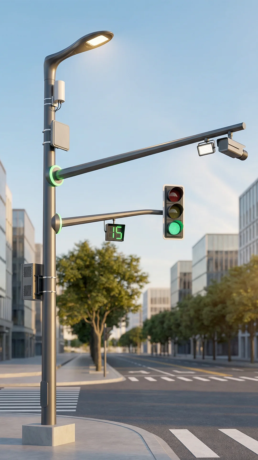
4K AI Camera
- 8MP, Starlight-level Night Vision
- Built-in AI chip, edge inference
- 360° PTZ, auto cruise patrol
- H.265+ encoding, low bandwidth
mmWave Radar
- 77GHz high-precision speed measurement
- Max detection range: 200m
- Max detection speed: 320 km/h
- All-weather: rain, fog, night
Intelligent Fill Light
- LED strobe supplemental lighting
- Auto brightness adjustment
- Non-blinding to drivers
- Synced with camera capture timing
LED Signal Light
- High-brightness LED matrix
- Adaptive timing control
- Countdown display
- Self-diagnosis fault alarm
45+ AI-Powered Detection Capabilities
From motorcycles to heavy trucks — every vehicle, every violation, every incident
Types of Detection
License Plate Accuracy
Response Time
Max Detection Speed
Violations caught by 8 cameras in weeks
Motorcycle & E-bike Intelligence
Purpose-built for developing market challenges where two-wheelers dominate traffic
of commercial motorcyclists involved in accidents (Nigeria)
of hospital patients from motorcycle overloading (Ethiopia)
of traffic flow is motorcycles (Southeast Asia)
No Helmet Detection
NVIDIA TAO + YOLOv8, F1-score 92.7%
Triple Riding Detection
Mask R-CNN rider counting
4+ Overloading
Common in developing countries
Motor Lane Intrusion
Lane + vehicle type fusion
Wrong-Way Riding
Direction detection algorithm
Oversized Cargo
Contour anomaly detection
Restricted Zone Entry
Vehicle type + geofencing
AI-Adaptive Signal Control with Green Wave
Every intersection learns, every corridor flows
Real-Time Adaptive
Dynamically adjusts signal timing based on live traffic flow. Multi-objective optimization: efficiency + pedestrian safety + transit priority.
Green Wave Coordination
Synchronize signals across arterial corridors. Vehicles pass through at constant speed without stopping.
Transit & Emergency Priority
Auto-detect buses, ambulances, fire trucks. Pre-switch to green, escort through corridor.
-25% travel, -20% emissions, -40% wait
-10~30% travel time at key intersections
-15% commute (Digital Twin optimization)
City Traffic Edge Runtime — 4-Layer Cloud-Native Platform
The intelligence behind every decision
Data Ingestion Layer
- •Multi-source fusion: Camera + Radar + Geomagnetic + Floating GPS
- •Real-time stream processing: Kafka + Flink
- •Data cleansing & standardization
- •Edge-to-cloud data pipeline
Analytics Layer
- •Real-time traffic situational awareness
- •Historical trend analysis
- •OD Matrix (Origin-Destination analysis)
- •Congestion prediction (next 30 min)
Decision AI Layer
- •Reinforcement learning signal optimization
- •Multi-objective planning (efficiency/safety/emissions)
- •Emergency response auto-trigger
- •LLM-powered scenario evaluation
Visualization Layer
- •Digital Twin 3D city model
- •Real-time heat maps
- •What-If scenario simulation
- •Traffic Edge Console natural language interaction
Traffic Edge Console-Powered Command Center
Control your city's traffic with natural language — the world's most advanced traffic HQ
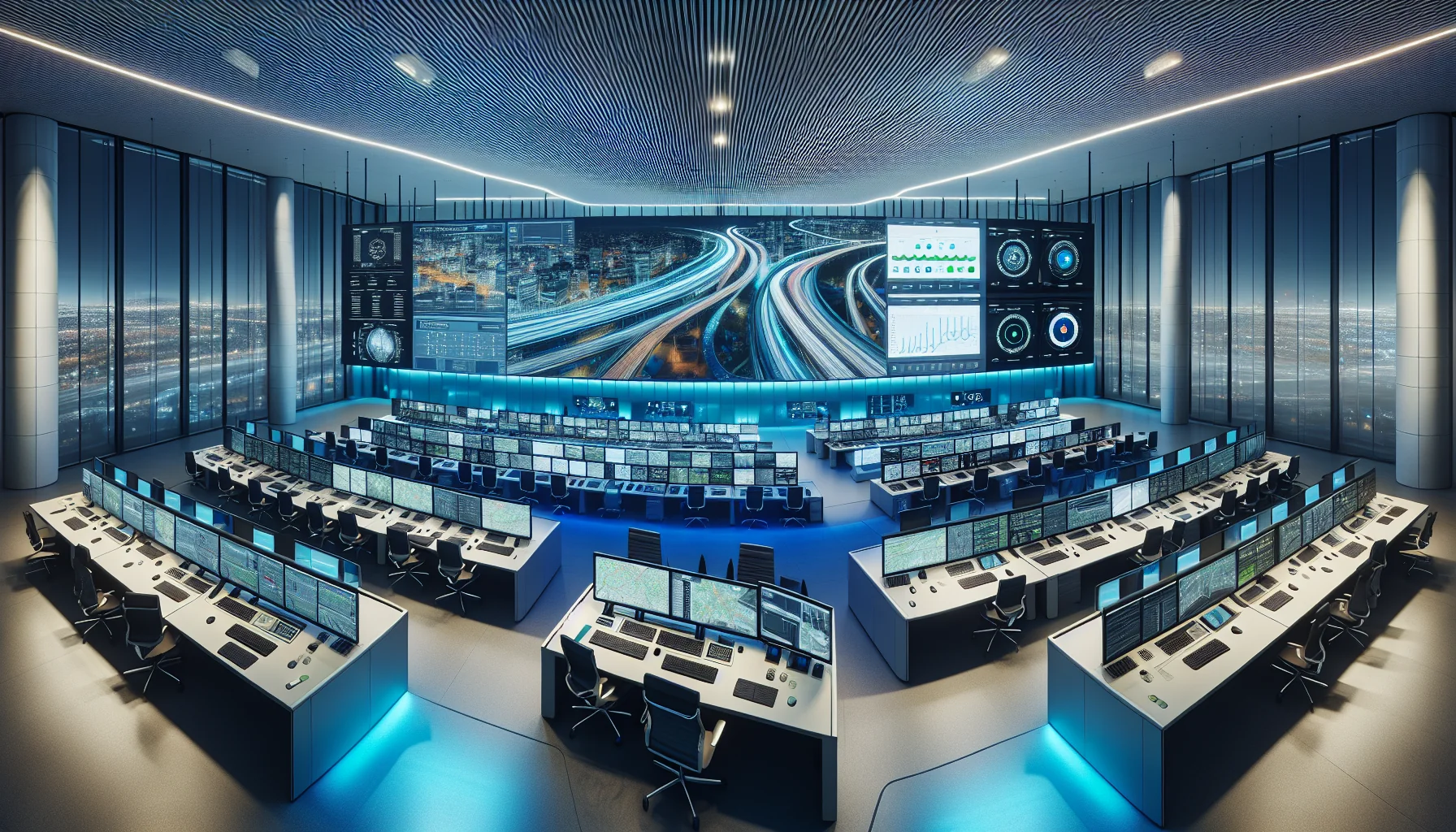
Not just a dashboard — a conversation with your city
Air-Ground Integrated Surveillance Network
Eliminate every blind spot with UAV + ground sensor fusion
UAV Swarm
- • Detection precision: 91.8%
- • Tracking: MOTA 92.1% / MOTP 93.7%
- • Use: traffic monitoring, incident response, events
- • Autonomous patrol + auto recharge
Ground Pole Network
- • City-wide coverage
- • Each pole = independent AI node
- • Multi-pole collaborative tracking
- • Fiber-connected backbone
Air-Ground Synergy
- • Real-time data sharing between air and ground
- • UAV detects incident → ground adjusts signals
- • Eliminates fixed-camera blind spots
- • Temporary aerial coverage for major events
V2X Ready — Built for Tomorrow's Roads
From connected vehicles to quantum-optimized cities
V2X Vehicle-to-Everything
- • C-V2X communication protocol
- • 84,000 signalized intersections globally connected
- • 2027 forecast: 60% vehicles V2X-capable
- • Accident reduction potential: 80% (US DOT)
6G Evolution
- • Smooth upgrade path: 5G → 5G-A → 6G
- • Latency: 10ms → <1ms (sub-millisecond)
- • Coordinate: thousands → 50,000+ intersections
- • Holographic comms, sensing fusion, AI-native
Quantum Computing Ready
- • Architecture pre-equipped with quantum interfaces
- • McKinsey: congestion reduction up to 50%
- • QAOA algorithm: peak travel time -15%
- • Simultaneously optimize 50,000 intersection signals
Our architecture evolves with technology — invest once, upgrade forever
Solar-Powered Smart Traffic — Only from SOLARTODO
We don't just build traffic systems — we power them
The world's only smart traffic system provider that is also a solar energy company
Solar + Storage Self-Powered
- • Solar panels integrated on pole tops
- • LFP battery storage for 24/7 operation
- • Works without grid electricity
- • Deploy anywhere — even off-grid regions
Dual Investment Return
- • Traffic management revenue (fine sharing)
- • Distributed generation revenue (surplus to grid)
- • Each pole = traffic device + micro power station
- • Accelerated payback period
Carbon Neutral Contribution
- • AI signal optimization reduces emissions by 20%
- • Solar power = zero-carbon system operation
- • Eligible for ESG credits and carbon trading
- • Government procurement bonus points
Blockchain-Secured Evidence & Privacy Protection
Tamper-proof, privacy-compliant, legally admissible
On-Chain Evidence
Blockchain immutable records from capture to legal enforcement. Full traceability with legal validity.
Decentralized Vehicle ID
Blockchain anonymous authentication. Prevents identity forgery and data tampering. No single point of failure.
Privacy Compliance
Authorized-only data access. designed to support GDPR and international data-protection workflows. Data minimization principle.
Cyber Security
Decentralized architecture resists DDoS. End-to-end encrypted communication. Zero-trust security model.
Smart Traffic Citizen App
Empowering citizens with real-time traffic intelligence
Live Traffic Map
Real-time congestion, incidents, and road conditions
AI Navigation
Optimal route recommendations avoiding congestion
Violation Query
View records and photos online
Online Payment
Multiple payment methods supported
Traffic Prediction
"How long will my commute be tomorrow?"
Incident Report
One-tap road condition reporting
Public Transit
Real-time bus arrival information
Accessibility
Voice, large text, multi-language support
Proven Results Worldwide
Real data from real deployments across 6 continents
Travel Time Reduction
Emergency Response
Violation Rate Change
CO2 Emission Reduction
| City | System | Result |
|---|---|---|
| Pittsburgh | SURTRAC AI Signal | -25% travel, -20% emissions |
| London | Smart Traffic Mgmt | -10~30% travel time |
| Singapore | Digital Twin | -15% commute time |
| Copenhagen | Data-Driven Transit | Significant GHG reduction |
| Rwanda | Digital Enforcement | Full automation, fewer accidents |
| Greece (2026) | 8 AI Cameras | 29,000 violations in weeks |
These aren't promises — they're proven results from cities around the world
Contributing to Carbon Neutrality & ESG Goals
Smart traffic is green traffic
AI Emission Reduction
Adaptive signal optimization reduces idle emissions by up to 20%. Source: TRENDS Research.
Solar-Powered Operation
System runs on zero-carbon solar energy. No grid dependency, no carbon footprint.
Modal Shift
Encourages public transit and reduces private car use. Helsinki MaaS: 38% users reduced daily driving.
Environmental
Reduced emissions, improved air quality
Social
Safer roads, better citizen experience
Governance
Transparent data, fair AI enforcement
3-Phase Implementation Roadmap
From pilot to city-wide deployment in 12-18 months
Phase 1: Pilot
- •Select 3-5 key intersections
- •Install smart poles + edge AI
- •Connect to City Traffic Edge Runtime
- •Validate detection accuracy & stability
- •Deliver pilot report + ROI analysis
Output: Pilot Report + ROI Analysis
Phase 2: Expansion
- •Expand to 50-100 intersections
- •Enable arterial green wave coordination
- •Launch automated enforcement
- •Release Citizen App
- •Build Command Center
Output: City-Level Operations
Phase 3: City-Wide
- •Full city coverage
- •Digital Twin goes live
- •V2X vehicle-to-everything testing
- •UAV swarm deployment
- •Traffic Edge Console command center online
Output: Smart Traffic City Benchmark
Every phase delivers measurable results — no need to wait for full deployment
Frequently Asked Questions
Ready to Transform Your City's Traffic?
Get a customized smart traffic solution tailored to your city's needs and budget