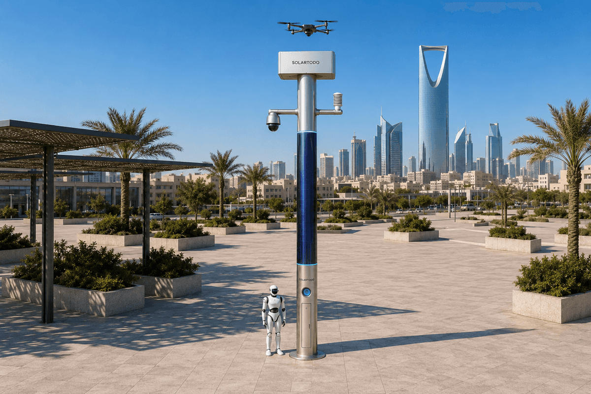
A City AI Pole is a non-lighting physical-AI edge node that combines off-grid energy, local sensing, edge compute, drone operations, and ground robot support in one urban pole. In Lisbon, SOLARTODO Sentinel Sky Hub is proposed as a river-cross-section deployment for transport-authority border-watch, environmental monitoring, and holiday coverage without exporting raw video from the pole.
1. Lisbon Task Context: Old-Town River Cross-Section During Holiday Peaks
Lisbon’s old-town mobility environment compresses many operating pressures into a narrow civic edge: ferry terminals, tram approaches, rail connections, cruise-adjacent flows, hillside pedestrian routes, heritage streets, and the Tagus riverfront. During holiday periods, the transport authority’s concern is not only passenger throughput. It is also situational coverage across a changing border between water, quays, bridges, public plazas, service lanes, and restricted operational areas.
This pilot-report configuration treats the riverfront as a cross-section rather than a single line. The proposed SOLARTODO Sentinel Sky Hub nodes would be positioned to observe and coordinate across selected slices of the river edge: approach paths, pier-side waiting areas, perimeter transitions, vehicle service points, and nearby old-town pedestrian corridors. The purpose is environmental and operational awareness for a transport-authority command view, not public lighting and not continuous raw-video export.
The seasonal trigger is the holiday surge, when passenger density, informal parking, noise, temporary barriers, extended operating hours, and weather changes can interact. A transport authority may need to know whether a riverside perimeter is becoming congested, whether wind conditions are suitable for a drone inspection, whether noise and particulate readings are trending above normal planning thresholds, or whether a ground robot should be sent to verify a local alarm without pulling staff away from a terminal.
The pain point selected for this configuration is drone endurance. Aerial patrols are valuable along a river-cross-section because a drone can move quickly between pier edges, approach roads, and restricted zones. But endurance is constrained by battery cycles, return-to-base timing, weather windows, and the need to avoid placing an operator on site for every sortie. In this deployment design, Sky Hub supports drone launch, patrol, inspection, return, automated rear-service battery hot-swap, and redeployment as part of a managed duty cycle.
The KPI framing is coverage: not claimed kilometers, detection rates, or achieved response times, but target evaluation of how consistently the authority can maintain awareness over selected riverfront sections during high-demand periods. Coverage is measured as planned patrol windows completed, cross-section checkpoints observed, environmental samples captured, robot verification tasks closed, and event metadata delivered to the common-operating-picture view for human decision-making.
2. Proposed Node Configuration: Off-Grid Physical AI, Not Street Lighting
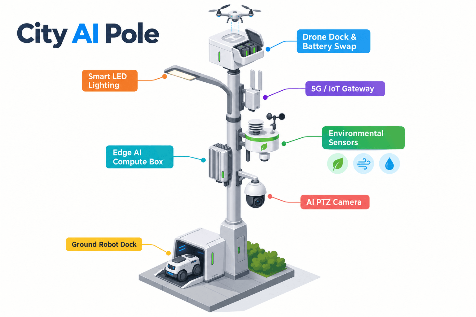
The proposed node is SOLARTODO Sentinel in its Sky Hub pole-form deployment shape. It is a pure smart pole with no lighting system. It is not a smart streetlight, does not include lamp heads, and does not depend on grid, city, or site power. The pole is configured as a fully off-grid, battery-backed physical-AI micro-station with edge compute, sensing, drone operations, and ground robot operations.
Energy design matters because the Lisbon use case is seasonal, mobile, and operationally sensitive. The pole carries approximately 15 m² of 360-degree wrapped flexible CIGS thin-film solar over a vertical body roughly 8 m tall and 0.6 m wide, with about 2.4–2.7 kWp nameplate capacity. The vertical wrap should not be interpreted as whole-surface simultaneous production. A cylindrical surface collects direct sun mainly on its sun-facing projection. In high-irradiance regions, realistic clear-sky output is roughly 0.8–1.1 kW DC peak, usually peaking mid-morning or mid-afternoon rather than at noon, and about 6–9 kWh per day. Lisbon planning should apply local irradiance, shading, riverfront wind, and seasonal-duty assumptions before final engineering confirmation.
The CIGS layer is therefore treated as supplemental replenishment for a fully off-grid battery-backed station, not as a claim of unlimited pure-solar self-sufficiency. High-power drone and robot tasks are buffered by 5–20 kWh-class storage and scheduled by duty cycle. During a holiday operating window, the authority can prioritize patrol frequency, drone redeployment, robot verification, and environmental sampling according to stored energy state, weather, and mission urgency.
Edge AI compute is housed on the pole for local inference and workload scheduling. A Jetson-class edge module, Orin- or Thor-class, can be specified technically without making the compute vendor the story. Raw video and sensor data stay on the pole and are processed locally. Only de-identified event and status metadata may leave the pole for the command view, such as a crowd-density band, anonymous vehicle count, intrusion flag, drone battery state, wind status, robot charging state, or mission log reference.
For environmental monitoring, the nine-in-one sensor set covers wind speed, wind direction, temperature, humidity, atmospheric pressure, noise, PM10, PM2.5, and illuminance. These readings are relevant to Lisbon’s riverfront because maritime wind, heat, dust, noise, and crowd conditions can affect whether a drone sortie is appropriate, whether a robot patrol should be dispatched instead, and whether the authority should alter staffing or access control around a transport node.
3. Operational Scenario: Border-Watch With Ground-Robot Focus
The operational scenario is border-watch, interpreted for Lisbon as supervised awareness at the urban-waterfront boundary and adjacent transport perimeter. The goal is not militarized control. It is practical transport-authority coverage: knowing what is happening at the edge of a terminal, restricted service path, dock transition, bridge approach, or riverside crowd zone, and deciding which field asset should verify or respond.
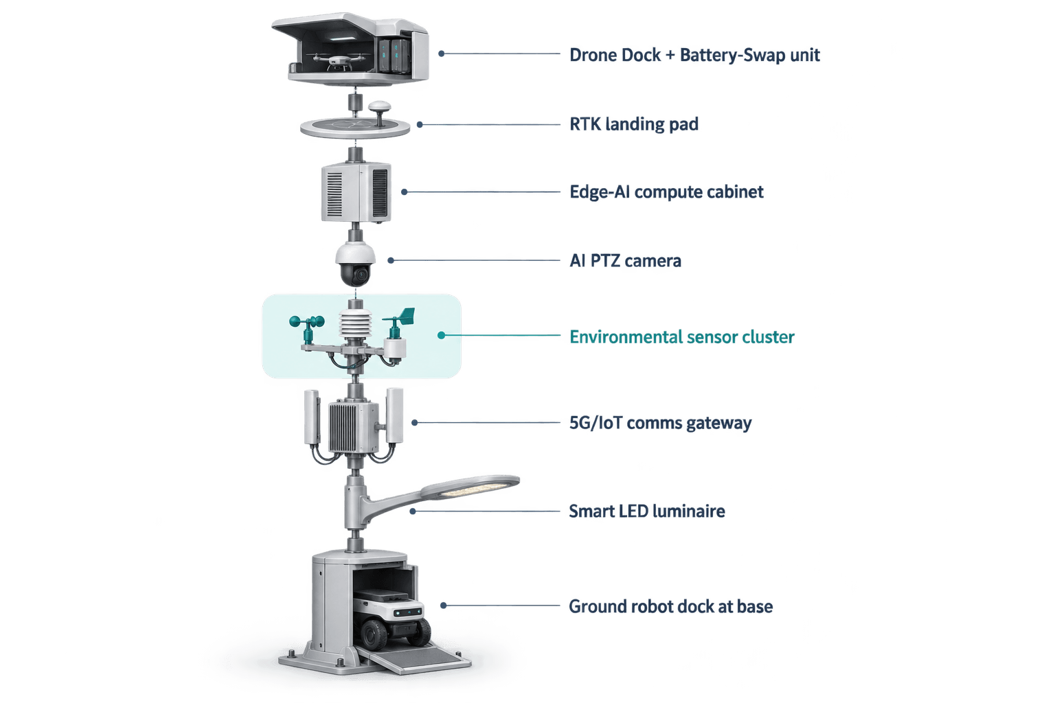
The module focus is ground robot operations. The Sky Hub base acts as a robot-ready service point where a humanoid or service robot can autonomously patrol, respond to alarms, inspect access points, coordinate with aerial observation, and return for wireless charging. This matters because the drone-endurance pain point cannot be solved by drones alone. When wind rises, when batteries are being swapped, when an aerial route should be conserved for a later inspection, or when verification requires proximity at ground level, the robot becomes the coverage stabilizer.
A typical holiday sequence begins with on-pole sensing. The PTZ camera and local perception layer may identify crowd density changes, anonymous vehicle accumulation, intrusion into a restricted perimeter, or a riverfront movement pattern that differs from normal operating rules. The environmental package checks wind, noise, particulate, and illuminance conditions. The edge scheduler then decides whether the event is better handled by camera confirmation, ground robot dispatch, drone sortie, or combined air-ground tasking.
If the event is ground-accessible, the service robot can leave the pole base and inspect the site while the pole keeps the COP updated with de-identified status metadata. If the event requires aerial context, the drone operations system can launch a sortie, follow a planned route, inspect a cross-section checkpoint, return, and receive an automated rear-service battery exchange from the multi-bay battery magazine. Multiple bays support several consecutive sorties, subject to duty-cycle planning and battery state.
Counter-UAS coordination is included as a non-lethal, human-authorized workflow. The pole can detect and track an unauthorized drone using its local sensing and optional partner-sensor inputs where engineered. Radar is not built into the pole; if required, radar would be treated only as an optional external or partner sensor input. After human authorization, the node may command its own friendly drone to perform soft aerial net-capture or close-approach deterrence. The workflow excludes shoot-downs, hard-kill measures, RF or GNSS jamming, denial effects, autonomous attack, or weaponized response.
The command view unifies the operations loop known as sensing, authorized assessment and response, edge-compute scheduling, and field operations and maintenance. In practice, this means the transport authority sees event class, confidence band, asset availability, energy state, environmental suitability, mission status, and logs in one common-operating-picture screen. Human authorization remains the control point for escalated response.
4. Coverage KPI: What the Pilot Would Evaluate
This pilot-report framing avoids claiming achieved results. Instead, it defines target evaluation metrics that a Lisbon transport authority could test subject to final engineering confirmation. The central KPI is coverage across the selected river-cross-section: whether the combined pole, drone, and ground robot configuration can maintain more consistent awareness during holiday peaks than a camera-only or manual-patrol-only arrangement.
Coverage should be evaluated in operational units that can be recomputed by the buyer. For example, planners can define cross-section checkpoints at ferry approaches, service gates, pedestrian pinch points, riverside barrier segments, and vehicle waiting areas. The target metric then becomes the number of scheduled checks completed per operating window, with drone tasks, robot tasks, and fixed sensing each counted separately. This prevents a vague technology claim from replacing an auditable operating plan.
Drone endurance is measured indirectly through task continuity. Instead of asking whether one drone can fly indefinitely, the authority evaluates how many planned aerial inspections can be completed before the node reaches a battery-reserve threshold, how quickly a landed drone can re-enter the task queue after automated battery exchange, and how often weather or energy rules shift work to the ground robot. This is a more credible measure because the solar layer replenishes energy while battery storage absorbs mission peaks.
Environmental coverage is also a transport KPI. Wind speed and direction determine aerial feasibility; noise, PM10, PM2.5, temperature, humidity, pressure, and illuminance help characterize operating conditions along the old-town riverfront. During holiday periods, those readings can support decisions about queue routing, temporary staffing, field inspection, and whether a local anomaly is environmental, operational, or security-related.
Data governance is part of the evaluation. Sky Hub is designed for local processing and PDPL/LGPD-oriented handling, with raw video and sensor data staying on the pole. The pilot would verify that only de-identified event and status metadata are exported to the COP, such as event type, timestamp, location zone, asset status, environmental values, and mission log references. This supports transport operations while limiting unnecessary data movement.
A successful evaluation would therefore be defined by planning evidence, not exaggerated claims: target patrol coverage, task completion, battery-state stability, environmental sampling completeness, human authorization records, and maintenance workload. Final placement, energy autonomy, sensor geometry, communications availability, and robot route design remain subject to site survey and engineering confirmation.
5. Buyer Takeaway: A Practical Edge Node for Lisbon Transport Operations
For a Lisbon transport authority, the value of the proposed SOLARTODO Sentinel Sky Hub deployment is not that it replaces all existing systems. The value is that it creates off-grid physical-AI nodes at difficult waterfront locations where sensing, environmental monitoring, aerial operations, ground inspection, and local compute need to work together without drawing city or site power.
The old-town context matters. Lisbon’s riverfront is visually sensitive, operationally dense, and seasonally variable. A non-lighting intelligent pole avoids positioning the system as street lighting and keeps the deployment focused on transport coverage, perimeter awareness, environmental conditions, and field operations. The pole form can host the edge stack, energy system, drone service workflow, and robot charging interface in one managed location.
The ground robot focus is especially relevant to holiday operations. A robot can inspect a closed gate, confirm a temporary barrier, check a service path, respond to an intrusion flag, or coordinate with an aerial view while the drone is recharging, swapping batteries, or held back by wind. That makes coverage more resilient because the authority is not relying on a single asset type.
The proposed pilot should be scoped as a measured evaluation: selected river-cross-section zones, defined holiday operating windows, target coverage checkpoints, planned drone duty cycles, ground robot patrol routes, and environmental thresholds. The output should be a common-operating-picture workflow that helps human supervisors decide when to observe, when to dispatch, when to authorize a response, and when to record an event for maintenance or review.
Sky Hub is therefore best understood as a physical-AI urban edge node for transport-authority coverage in complex waterfront environments. It combines edge computing, autonomous drone operations, ground robot operations, local sensing, off-grid energy, and human-authorized response into one field station, while keeping raw data on the pole and treating solar as realistic replenishment rather than a limitless energy promise.
System Configuration
| Parameter | Configuration |
|---|---|
| Deployment mode | River-cross-section placement for selected Lisbon old-town waterfront transport zones, subject to final site survey |
| Pole type | SOLARTODO Sentinel Sky Hub pure smart pole; non-lighting physical-AI edge node with no lighting system |
| Energy system | Fully off-grid battery-backed micro-station with ~15 m² 360° wrapped flexible CIGS replenishment and 5–20 kWh-class storage |
| Edge AI compute | On-pole Jetson-class edge module for local inference, workload scheduling, and event metadata generation |
| Security sensing | AI PTZ perception for anonymous vehicle count, crowd density, intrusion, and perimeter awareness |
| Environmental package | Wind speed, wind direction, temperature, humidity, atmospheric pressure, noise, PM10, PM2.5, and illuminance |
| Robot and drone operations | Ground robot wireless charging at pole base plus drone launch, patrol, return, automated multi-bay battery hot-swap, and mission logging |
How It Works
- On-pole sensing flags a riverfront anomaly, environmental threshold, or perimeter event.
- Edge AI classifies the event locally and scores whether camera, robot, drone, or combined verification is suitable.
- A human supervisor reviews the COP prompt and authorizes any escalated field response.
- The scheduler dispatches the ground robot, launches a drone sortie, or queues both according to energy, weather, and mission state.
- The node records mission status, battery state, environmental readings, and de-identified event metadata for operational review.
Planning Assumptions (Indicative)
Illustrative planning inputs a buyer can recompute — target metrics, not achieved results. Subject to final engineering confirmation.
| Metric | Planning assumption | Indicative value |
|---|---|---|
| Coverage checkpoints | Transport authority defines fixed river-cross-section checkpoints for holiday operating windows | ~10–20 checkpoints per zone planned |
| Inspection labor | Drone and robot patrols reduce the need for repetitive manual perimeter walks during peak periods | ~5–10 routine patrols/week automated per zone |
| Drone continuity | Automated battery hot-swap supports task redeployment without keeping an operator at the pole | ~3–6 consecutive sorties planned before reserve review |
| Ground verification | Ground robot handles local alarm confirmation when aerial dispatch is weather-limited or battery-constrained | ~50–70% of low-risk verification tasks targeted for robot triage |
| Environmental sampling | Nine-in-one environmental readings are captured at regular planning intervals for operational context | ~5–15 minute sampling cadence configurable |
| Data minimization | Raw video and sensor data remain on-pole while the COP receives de-identified events and status metadata | 100% raw-data-local processing target |
Deployed Equipment
- SOLARTODO Sentinel Sky Hub non-lighting smart pole body
- 360° wrapped flexible CIGS thin-film solar layer
- 5–20 kWh-class on-pole battery storage cabinet
- On-pole edge AI compute cabinet
- AI PTZ camera for local perception
- Nine-in-one environmental sensor package
- Autonomous drone bay with multi-bay battery hot-swap magazine
- Ground robot wireless charging interface at pole base
Frequently Asked Questions
Is this a smart streetlight deployment for Lisbon?
No. The proposed Sky Hub configuration is a pure smart pole and physical-AI urban edge node with no lighting system. It should not be treated as a streetlight upgrade. The deployment task is transport-authority coverage, environmental monitoring, drone operations, and ground robot support along selected old-town riverfront cross-sections.
How does the system address the drone-endurance pain point?
The design avoids assuming that one drone can operate continuously. Instead, the pole manages launch, patrol, return, automated rear-service battery exchange, task queueing, and redeployment. Multiple battery bays support consecutive sorties, while the edge scheduler uses battery state, storage reserve, weather, and mission priority to decide when to fly and when to shift work to the ground robot.
What role does the ground robot play in this pilot configuration?
The ground robot is the stabilizing field asset for coverage. It can leave the pole base for patrol, inspection, alarm response, and close-range verification, then return for wireless charging. This is especially useful when wind conditions limit drone sorties, when batteries are being swapped, or when a human supervisor needs ground-level confirmation before taking operational action.
Does raw video leave the pole or get uploaded to a central cloud?
The proposed data-handling model keeps raw video and sensor data on the pole for local processing. The common-operating-picture view receives only de-identified event or status metadata, such as event category, zone, timestamp, environmental readings, mission state, and asset health. The design is PDPL/LGPD-oriented, subject to final legal and engineering review.
Can the pole perform counter-UAS actions near the riverfront?
The counter-UAS workflow is limited to non-lethal, human-authorized coordination. The pole may detect and track an unauthorized drone using local sensing and optional partner-sensor inputs, then request supervisor authorization before commanding a friendly drone for soft net-capture or close-approach deterrence. It does not perform jamming, shoot-downs, hard-kill actions, or autonomous attacks.
Is the off-grid solar layer enough for unlimited operation?
No unlimited self-sufficiency claim is made. The pole is fully off-grid because it combines battery storage with on-pole CIGS replenishment, but high-power drone and robot tasks are scheduled by duty cycle. The vertical solar wrap is a supplemental replenishment layer, and final autonomy depends on Lisbon site conditions, shading, season, workload, and reserve policy.
What should a transport authority measure during the pilot?
The strongest evaluation frame is coverage rather than generic technology performance. The authority can measure planned checkpoints completed, drone sorties redeployed after battery exchange, robot verification tasks closed, environmental samples captured, human authorization records, battery reserve stability, and the quality of de-identified event metadata presented in the COP.
Explore Further
- City AI Pole / smart streetlight product line
- More smart-city deployment cases
- Talk to our engineering team
Planning a similar physical-AI deployment for streets, campuses or public spaces? Request an engineering consultation