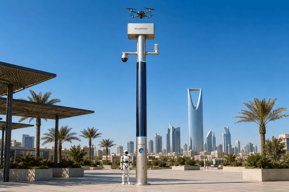
City AI Pole / Sentinel is a non-lighting physical-AI edge-node pole that combines off-grid energy storage, wrapped CIGS solar replenishment, local edge compute, sensing, communications, drone operations, ground robot operations and human-authorized response workflows. In this Mexico City water-authority scenario, one Sky Hub is proposed as a night-patrol node for outage-resilient inspection, anomaly triage and cross-department coordination during typhoon-season conditions.
Mountain-City Water Operations Context
Mexico City is a high-elevation basin city where water operations are shaped by terrain, rainfall concentration, subsidence, drainage constraints and long linear infrastructure. A water authority does not only manage treatment plants and office facilities; it also protects pumping stations, reservoirs, canal edges, culverts, valve yards, service roads and perimeter zones that may be quiet at night but operationally critical during storm events. In typhoon-season conditions, tropical storm remnants and intense rainfall can raise the workload even when the city is far from a coastal landfall. The immediate operational question is not how to add another connected camera. It is how to keep a field node working when network service is degraded, when site access is slow, and when several departments need the same evidence-based picture at the same time.
The proposed deployment is intentionally scoped as a single-pilot configuration. One SOLARTODO Sentinel Sky Hub would be positioned at a representative water-authority asset such as a reservoir perimeter gate, stormwater pumping access road, or drainage-control compound at the edge of a smart district. The site would be selected for realistic engineering confirmation: open sky for solar replenishment, safe drone launch geometry, robot-accessible ground paths, acceptable civil foundation conditions, and a communications profile that includes normal service plus expected outage periods. The purpose is to evaluate response-time improvement as a target planning metric, not to claim completed results.
This case treats Sky Hub as a city-ai-pole and physical-AI urban edge node, not as a street-lighting asset. It is a pure non-lighting intelligent pole with no lighting system. Its role is to host sensing, edge compute, off-grid energy, autonomous drone operations, ground robot operations and communications continuity at a water-infrastructure site where the night-patrol task matters more than decorative streetscape functions.
Edge-Computing Design For Network Outage
The primary pain point is network outage. In a conventional remote surveillance pattern, the most useful data path often fails at the worst moment: heavy rain, congestion, damaged communications cabinets, mobile backhaul instability or saturated control-room links. For a water authority, the operational consequence is delay. A perimeter alarm may be real, a blocked service gate may need intervention, a culvert access point may show unusual movement, or an unauthorized drone may appear near a sensitive operating zone, but the central team may lack enough context to decide quickly.
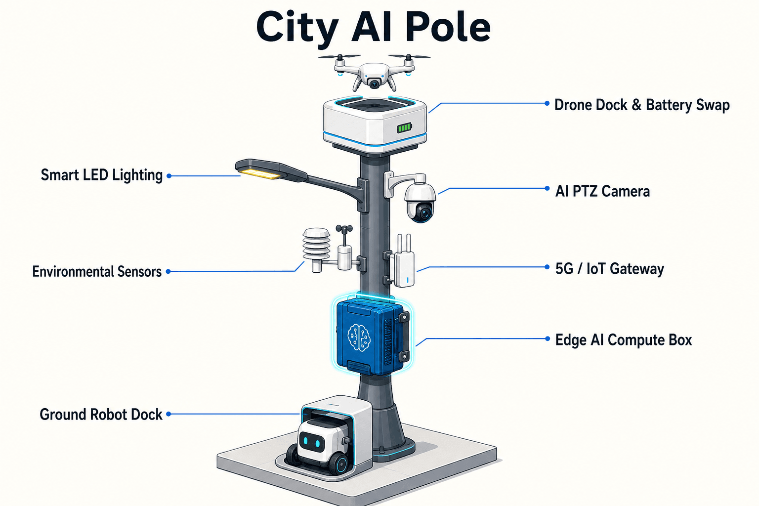
Sky Hub changes the design center from cloud-first viewing to on-pole decision support. A Jetson-class edge module in the pole runs local inference and workload scheduling. Raw video and sensor data stay on the pole and are processed locally; only de-identified event and status metadata may leave the pole. During normal connectivity, the command view receives event summaries, mission status, equipment health and audit logs. During network degradation, the pole continues to sense, classify, score, record locally and schedule authorized field actions according to policy. When communications return, the node synchronizes de-identified event records and mission logs rather than uploading continuous raw feeds.
The communications module is the focus of this configuration. The proposed node would use a layered communications design: primary cellular or private wireless backhaul where available, local short-range links for robot and drone coordination, local on-pole storage for outage periods, and optional partner or site-network inputs where approved. The pilot evaluation should measure the time from local anomaly detection to human reviewable event packet, the time from authorization to drone or robot task start, and the time required to restore a common operating picture after intermittent connectivity. Those are response-time targets for planning and acceptance testing, subject to final engineering confirmation.
Night-Patrol Operations Loop
The operational scenario is night patrol across a water-authority site during storm-season conditions. The pole's PTZ camera performs patrol patterns and local perception for anonymous vehicle count, crowd density, intrusion and perimeter awareness. The environmental package records wind speed, wind direction, temperature, humidity, atmospheric pressure, noise, PM10, PM2.5 and illuminance. These measurements help the authority understand whether a field response is happening in ordinary night conditions, heavy rain, high wind, poor visibility, high particulate conditions or abnormal acoustic patterns around a facility.
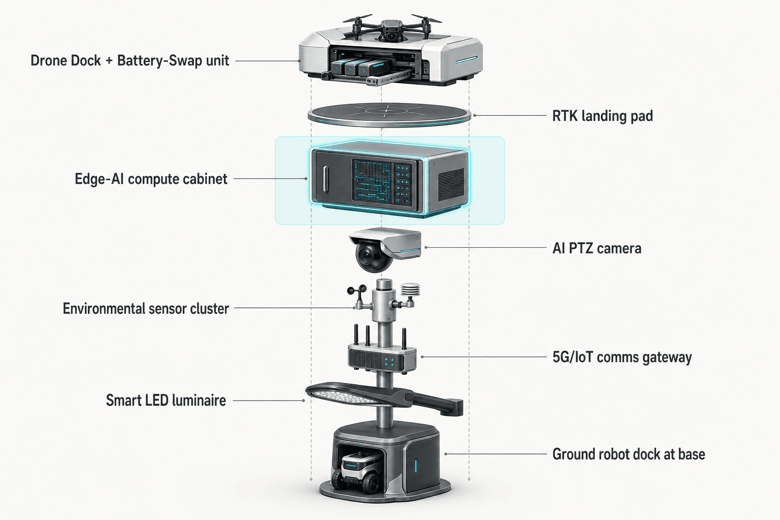
When the edge node flags an anomaly, OTATODO organizes the workflow as sensing, authorized assessment and response, edge-compute scheduling, and field operations and maintenance. The common-operating-picture command view presents the event state without requiring raw video to leave the pole by default. A duty officer can compare the local AI score, recent environmental conditions, node health, communications status, drone readiness, robot charging state and mission queue. If the event is low confidence, the node can continue observing locally. If it requires inspection, the human operator can authorize a drone sortie, a ground robot patrol, or a coordinated air-ground response.
For drone operations, the node supports launch, regional patrol, inspection, return and task redeployment with no operator on site. A landed drone can receive an automated rear-service battery exchange from a multi-bay battery magazine, allowing several consecutive sorties within the configured duty cycle. For ground operations, a humanoid or service robot can patrol the base area, inspect access points, respond to alarms, coordinate with the drone and return to the pole base for wireless charging. For Counter-UAS coordination, the pole may detect and track an unauthorized drone and command its own friendly drone for soft aerial net-capture or close-approach deterrence only after human authorization. This is non-kinetic and authority-bound; radar, if used, is only an optional partner-sensor input and is not built into the pole.
Off-Grid Resilience And Duty-Cycle Scheduling
The Mexico City case is proposed as a fully off-grid micro-station. Sky Hub does not depend on grid, city or site power. The pole carries battery storage plus approximately 15 square meters of 360-degree wrapped flexible CIGS thin-film over a vertical cylindrical body about 8 meters tall and about 0.6 meters wide. This corresponds to roughly 2.4 to 2.7 kWp nameplate. Because a vertical cylinder collects direct sun only on its sun-facing projection, not from the whole wrap at once, the energy model must be conservative. In a high-irradiance region, realistic clear-sky output is roughly 0.8 to 1.1 kW DC peak, with peak timing more likely in mid-morning or mid-afternoon than at noon, and about 6 to 9 kWh per day.
For Mexico City, the final generation estimate would need site-specific solar modeling, shade study, air-quality assumptions, seasonal rainfall profile and load scheduling. The important point is that the wrapped CIGS is a supplemental replenishment layer for a battery-backed off-grid station, not a claim of unlimited solar self-sufficiency. High-power drone and robot activity is buffered by 5 to 20 kWh-class storage and scheduled by duty cycle. The pole can prioritize core sensing, local inference, communications beacons, event logging and essential patrol tasks when battery state is constrained.
During storm-season night patrol, this energy model matters because the water authority is trying to keep the node alive through uncertainty. The system can reduce nonessential workloads, delay lower-priority sorties, keep the communications stack available for event metadata, and preserve local evidence until links recover. That turns energy management into an operational response-time function: the node must spend stored energy on the tasks that shorten time to assessment and authorized action.
Cross-Department Evaluation Model
A water-authority deployment cuts across operations, security, IT, legal, field maintenance and emergency coordination. The proposed pilot should therefore be governed as a cross-department evaluation rather than a narrow device trial. Operations defines which assets and night events matter. Security defines perimeter rules and escalation thresholds. IT validates communications behavior, local storage, audit export and cybersecurity alignment. Legal and data-governance teams review the PDPL-LGPD-oriented design posture: local processing, raw data staying on the pole, de-identified metadata leaving the site only where policy permits, and no active face or licence-plate recognition claim. Field maintenance confirms access, foundation, cleaning, battery service, drone-safe zones and robot paths.
The KPI frame is response time, but response time should be decomposed so each department can recompute it. Useful target inputs include time from on-pole anomaly flag to local event package, time from event package to human authorization, time from authorization to drone launch or robot departure, time from field inspection to event closure, and time to restore synchronized logs after an outage. The evaluation should not invent coverage area, detection rate or completed-result numbers before testing. Instead, it should define target thresholds, run night drills under agreed conditions, preserve logs, and compare the workflow against the authority's existing manual patrol process.
The single-pilot mode keeps the scope credible. One node is enough to validate whether a physical-AI edge pole can maintain a common operating picture when the network is unreliable, whether air-ground operations shorten assessment time for hard-to-reach water assets, and whether off-grid energy plus local compute can support a practical night-patrol duty cycle. Expansion decisions would remain subject to final engineering confirmation, local approvals, airspace procedures and the authority's internal acceptance criteria.
System Configuration
| Parameter | Configuration |
|---|---|
| Deployment mode | Single proposed Sky Hub pilot node at a Mexico City water-authority perimeter or drainage-control asset, subject to final engineering confirmation |
| Energy system | Fully off-grid battery-backed micro-station with approximately 15 m² wrapped flexible CIGS solar replenishment and 5-20 kWh-class storage |
| Edge AI compute | Jetson-class on-pole inference cabinet running local perception, workload scheduling and event-summary generation |
| Communications | Layered comms module with primary wireless backhaul, local robot and drone links, outage buffering and metadata synchronization |
| Camera and sensing | AI PTZ for anonymous vehicle count, crowd density, intrusion and perimeter awareness; no face or licence-plate recognition claim |
| Environmental monitoring | Wind speed, wind direction, temperature, humidity, atmospheric pressure, noise, PM10, PM2.5 and illuminance |
| Air-ground operations | Autonomous drone sorties with rear-service battery hot-swap plus ground robot patrol and wireless charging at the pole base |
How It Works
- On-pole PTZ and environmental sensors flag a night anomaly at the water-authority site.
- Edge AI classifies the event locally and creates a de-identified event packet while raw data stays on the pole.
- The COP view presents confidence, location, weather, node health, comms state and available drone or robot actions.
- A human operator authorizes drone launch, robot patrol, continued observation or escalation under the authority's rules.
- OTATODO records the mission log, response timestamps, battery state and synchronization status for later review.
Planning Assumptions (Indicative)
Illustrative planning inputs a buyer can recompute — target metrics, not achieved results. Subject to final engineering confirmation.
| Metric | Planning assumption | Indicative value |
|---|---|---|
| Inspection labor | Target planning input where drone and robot patrols replace a portion of manual night rounds at one selected asset | ~5-10 patrol tasks per week automated for evaluation |
| Response-time KPI | Target planning input from local anomaly flag to human-reviewable event packet during normal or degraded connectivity | ~5-10 minutes target triage window |
| Outage resilience | Target planning input for local event retention and delayed metadata synchronization when the backhaul is unavailable | ~24-48 hours of priority event buffering |
| Drone sortie continuity | Target planning input for consecutive inspection sorties supported by multi-bay battery exchange and duty-cycle scheduling | ~3-5 consecutive task redeployments per operating window |
| Cross-department review | Target planning input for security, operations, IT and maintenance teams to close a night-patrol event in one COP workflow | ~1 shared event record per incident |
Deployed Equipment
- SOLARTODO Sentinel Sky Hub non-lighting smart pole
- OTATODO edge OS runtime and COP command view
- Wrapped flexible CIGS thin-film solar replenishment layer
- Battery-backed off-grid energy cabinet
- AI PTZ camera with local perception
- Nine-parameter environmental monitoring package
- Autonomous drone hangar with multi-bay rear-service battery magazine
- Ground robot wireless charging interface at the pole base
Frequently Asked Questions
Is Sky Hub a smart streetlight for Mexico City?
No. Sky Hub is a pure non-lighting smart pole and physical-AI edge node. The Mexico City water-authority scenario uses the pole for edge computing, communications continuity, sensing, drone operations, robot operations and human-authorized response workflows. It includes no lighting system and should not be evaluated as a street-lighting replacement.
How does the node keep working during a network outage?
The proposed configuration is designed around local processing. The pole continues to run perception, event scoring, mission scheduling, local storage and equipment-health monitoring even when backhaul is degraded. Raw video and sensor data stay on the pole; only de-identified event and status metadata may synchronize when policy permits and communications recover.
What makes this relevant to a water authority rather than a generic security deployment?
The operating problem is protecting water assets at night during storm-season conditions, where pumping access, reservoir perimeters, culverts, gates and service roads may need fast assessment. The case is framed around response-time evaluation, outage-resilient communications and cross-department coordination between operations, security, IT, legal and field maintenance teams.
Does the deployment claim face recognition or licence-plate recognition?
No. The sensing scope is deliberately limited to anonymous vehicle count, crowd density, intrusion and perimeter awareness, supported by environmental context. The data posture is PDPL-LGPD-oriented and designed for local processing. Any future regulated identification workflow would require separate authorization, policy review and engineering confirmation.
Can the pole operate only from its wrapped CIGS solar layer?
The pole is fully off-grid, but the solar layer is a replenishment source for a battery-backed micro-station, not an unlimited self-sufficiency claim. Around 15 m² of wrapped CIGS may provide single-digit kWh per day in high-irradiance conditions, while high-power drone and robot tasks are buffered by storage and scheduled by duty cycle.
How is Counter-UAS handled in this case?
Counter-UAS coordination is non-kinetic and human-authorized. The pole may detect and track an unauthorized drone and, after authorization, command its own friendly drone for soft aerial net-capture or close-approach deterrence. It does not perform shoot-downs, jamming, autonomous attack or weaponized response. Radar is only an optional partner-sensor input if approved.
Explore Further
- City AI Pole / smart streetlight product line
- More smart-city deployment cases
- Talk to our engineering team
Planning a similar physical-AI deployment for streets, campuses or public spaces? Request an engineering consultation