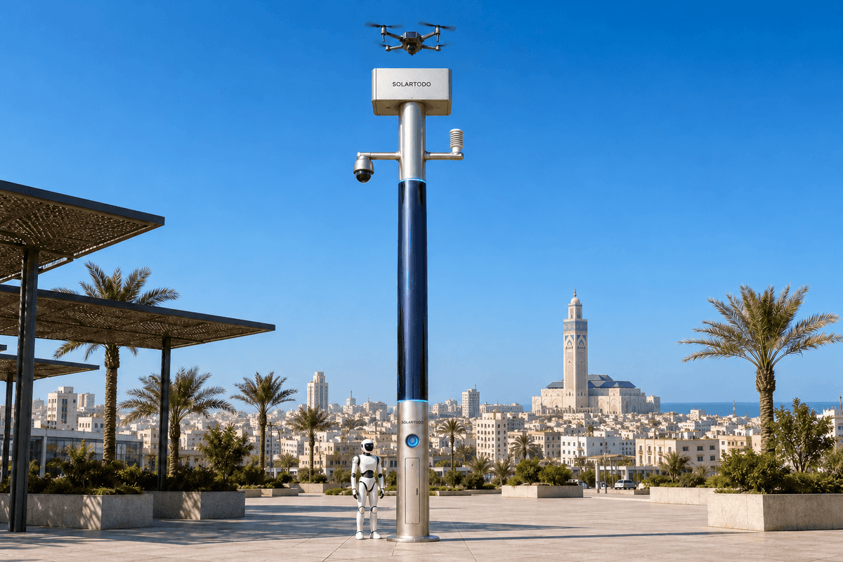
A City AI Pole is a non-lighting physical-AI edge node combining local computing, sensing, communications, energy storage, and coordinated drone and ground-robot operations. SOLARTODO Sentinel’s Sky Hub form runs OTATODO at the edge. This proposed Casablanca configuration supports temporary flood-season industrial-park border watch, processing raw data on-pole and sharing only de-identified event and status metadata.
1. The investment question: can temporary coverage close perimeter blind spots?
For a Casablanca industrial-park operator, flood-season preparedness includes maintaining awareness when temporary barriers, diverted deliveries, parked trailers, or restricted access change the perimeter. This case examines a proposed temporary-event deployment supporting a flood-season logistics operation. Border watch means watching the industrial park’s operational boundary, gates, and adjoining access corridors. The buyer’s question is practical: does a relocatable edge node make previously obscured areas observable and actionable during the event?
There is a documented local reason to examine this scenario. The OECD’s Morocco risk-management review records major flooding in Casablanca’s Sidi Bernoussi industrial district in 2010. That historical example supports preparedness planning; it does not establish current flood exposure at an unnamed property. Drainage, access, elevation, and communications conditions require a site survey. OECD Review of Risk Management Policies: Morocco
The proposed deployment applies SOLARTODO Sentinel’s in-service Sky Hub capabilities to this operating problem. It describes an illustrative configuration, not a completed Casablanca customer installation or measured outcome. The park operator would define the temporary boundary, observation priorities, event duration, and authorization responsibilities before positioning equipment.
Coverage is the primary evaluation metric. A zone counts as covered only when the agreed observation task can be performed, the node can interpret relevant observations locally, and an actionable event can reach the responsible operator. A camera icon on a map does not establish coverage. This definition connects sensing, edge computing, and communications to a decision the park operator can actually use.
2. Where the return comes from: communications that make observation usable
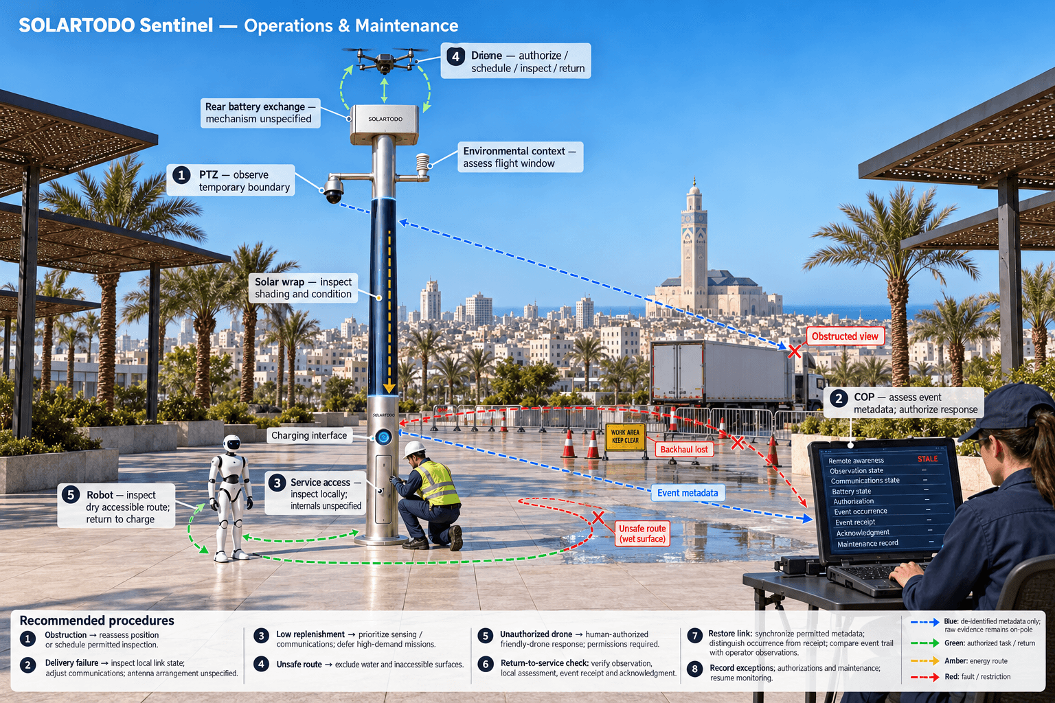
The main communications problem is continuity between local observation and authorized action. A temporary perimeter can shift faster than permanent infrastructure. A trailer may block a view; a revised delivery route may move activity outside an existing camera’s useful angle. The proposed node therefore combines an on-pole industrial communications gateway, local operational links, and a surveyed wireless backhaul arrangement. Link selection, antenna placement, and any secondary path remain subject to final engineering confirmation.
OTATODO runs inference and schedules workloads on the pole. Camera analysis, environmental processing, mission coordination, and energy management remain local. The communications layer carries de-identified events, task acknowledgments, equipment health, and status changes to the common-operating-picture command view. Raw video and sensor data stay on the pole; the remote command view receives neither raw feeds nor raw sensor streams.
This architecture makes coverage assessable during a backhaul interruption. The node can continue permitted local sensing and record events on-pole, while the command view marks remote awareness as stale or unavailable. It must not show uninterrupted remote coverage merely because local processing continues. Subsequent synchronization carries permitted event and status metadata, with timestamps that distinguish event occurrence from receipt.
The operator should evaluate each priority zone under representative temporary obstructions and communications conditions. A useful record links the zone, observation state, communications state, event acknowledgment, and authorized response. Reviewing those records reveals whether a blind spot comes from physical obstruction, insufficient observation, or failed event delivery. Each cause calls for a different remedy: repositioning, a scheduled inspection, or communications adjustment. That diagnostic value is central to the proposed return.
3. How the integrated node turns coverage into a response
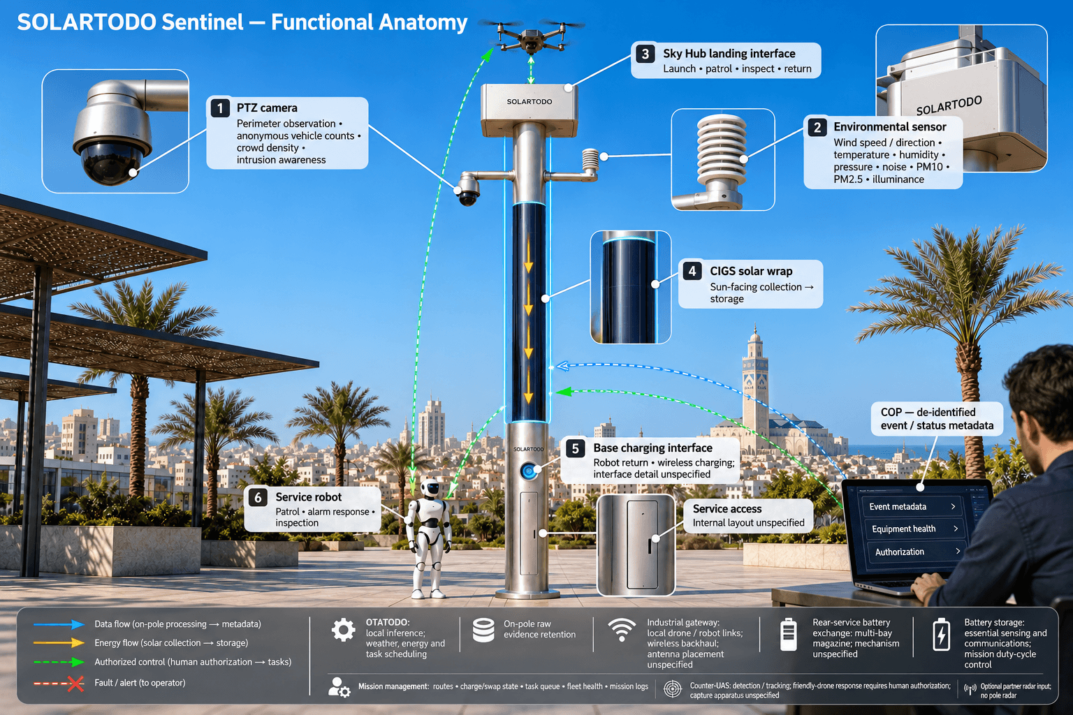
Sky Hub is a PURE smart pole with no lighting system. Its nine integrated capabilities connect the physical host, drone operations, automated drone battery exchange, drone management, ground-robot operations, security sensing, environmental monitoring, edge computing, and counter-UAS coordination. For this case, their purpose is to support perimeter awareness through the communications and local-compute layer, rather than operate as unrelated equipment.
A PTZ camera supports anonymous vehicle counts, crowd density, intrusion awareness, and perimeter observation. The nine-in-one environmental package measures wind speed, wind direction, temperature, humidity, atmospheric pressure, noise, PM10, PM2.5, and illuminance. These measurements provide operating context; they do not directly measure flood depth. Wind conditions can inform whether an aerial inspection should proceed, while local perception can flag an obstruction requiring assessment.
Drone operations cover launch, regional patrol, inspection, return, and task redeployment without an operator stationed at the pole. After landing, an automated rear-service mechanism exchanges the battery using a multi-bay magazine. Several charged packs support consecutive sorties within energy and operating limits. Mission management coordinates routes, the charge/swap state machine, queued tasks, fleet health, and mission logs. No unrestricted or continuous flight availability is implied.
A service or humanoid ground robot supports autonomous patrol, alarm response, inspection, and air-ground coordination, returning to the pole base for wireless charging. Flood-season routing must exclude unsafe water, unsuitable surfaces, and inaccessible corridors. Neither aerial nor ground operations replace physical access controls or the operator’s incident responsibilities.
The common operating picture joins sensing, authorized assessment and response, edge-compute scheduling, and field operations and maintenance. For an unauthorized drone, Sentinel detects and tracks the event and supports human-authorized command of its own friendly drone for soft aerial net-capture or close-approach deterrence. This non-lethal, non-kinetic workflow requires the relevant operating authority. Radar is not pole hardware; any radar information would be an optional partner-sensor input.
4. The off-grid constraint belongs inside the ROI calculation
Temporary deployment avoids a power-connection dependency because Sky Hub is fully off-grid, using on-pole solar replenishment and battery storage. It does not use grid, city, or site power. However, eliminating a connection does not eliminate energy constraints. The proposed operating schedule must account for compute, communications, sensing, battery exchange, robot charging, and the reserve needed to maintain essential awareness.
The cylindrical body is approximately 8 metres tall and 0.6 metres wide, carrying about 15 square metres of 360-degree-wrapped flexible CIGS thin-film solar, with approximately 2.4–2.7 kWp nameplate capacity. The entire wrap does not receive direct sunlight simultaneously. Direct collection depends on the sun-facing projection, so nameplate capacity must not be treated as continuously available power.
As a reference for a high-irradiance region such as Saudi Arabia, realistic clear-sky output is approximately 0.8–1.1 kW DC peak and 6–9 kWh per day, with peaks around mid-morning or afternoon rather than noon. These are reference figures, not a Casablanca production forecast. Local shading, weather, orientation, conversion losses, and seasonal conditions require assessment before an energy budget is accepted.
Solar is supplemental replenishment for a battery-backed micro-station. Storage in the 5–20 kWh class buffers high-power drone and robot tasks, while duty-cycle scheduling limits their demand. A flood-season schedule should prioritize essential sensing and communications when replenishment falls. Coverage evaluation must record deferred missions and energy-related unavailability. Otherwise, a calculation could incorrectly attribute full coverage to equipment that lacks enough energy to perform the agreed task.
5. A recomputable business case and an evidence-based decision
For the park operator, the first return calculation should use operational units rather than an unsupported financial payback. Define priority zones, required observation windows, and the conditions under which each zone qualifies as covered. Then calculate covered zone-hours divided by required zone-hours. Keep the denominator fixed during comparison, and disclose any boundary changes introduced by the temporary event.
The illustrative assumptions below show how to structure that comparison. They are hypothetical planning inputs, not local statistics, measured product performance, or achieved results. For example, twelve zones observed for ten hours per day across twenty days create 2,400 required zone-hours. Comparing alternative coverage assumptions against that same requirement makes the proposed improvement explicit without presenting it as a promise.
A separate effort calculation can estimate how many manual blind-spot verification rounds might be avoided. The operator must distinguish genuinely avoided work from work transferred to event review, drone supervision, robot assistance, battery servicing, or maintenance. Record setup, relocation, permissions, communications provisioning, and removal effort as well. Without those inputs, temporary deployment can appear more efficient than the complete operating workflow warrants.
Acceptance should depend on representative evidence: changing obstructions, stale communications, unavailable flight windows, ground-route restrictions, and reduced solar replenishment. Review the event trail against operator observations and inspect raw evidence locally on the pole where authorized. Remote reporting should contain only de-identified event and status metadata. Local processing and PDPL/LGPD-oriented design do not establish certification or legal compliance; the operator must assess Moroccan requirements separately.
The resulting decision is whether the proposed configuration supplies enough dependable, actionable perimeter coverage for this temporary Casablanca operation to justify its deployment and support effort. Approve it against agreed coverage targets, documented exceptions, and a confirmed engineering plan. No coverage gain, staffing reduction, customer acceptance, or financial return is claimed as achieved in this case.
System Configuration
| Parameter | Configuration |
|---|---|
| Physical host | PURE non-lighting cylindrical smart pole, approximately 8 m tall and 0.6 m wide; temporary positioning subject to foundation, wind-load and access engineering |
| Edge computing and data | On-pole AI inference and OTATODO workload scheduling; raw video and sensor data retained and processed on-pole |
| Communications | Industrial gateway, local drone/robot operational links and surveyed wireless backhaul; outward traffic restricted to de-identified event/status metadata |
| Security and environmental sensing | PTZ camera plus wind speed, wind direction, temperature, humidity, atmospheric pressure, noise, PM10, PM2.5 and illuminance monitoring |
| Drone and robot facilities | Drone landing interface, automated rear-service multi-bay battery exchange and ground-robot wireless charging base |
| Off-grid energy | Approximately 15 m² wrapped flexible CIGS, 2.4–2.7 kWp nameplate, and 5–20 kWh-class storage; capacity and duty cycle subject to final engineering confirmation |
How It Works
- On-pole sensing flags a perimeter anomaly in an agreed priority zone.
- Edge AI assesses the observation locally and creates a de-identified event.
- The COP presents event metadata for human assessment and response authorization.
- OTATODO schedules an authorized inspection against energy, weather and communications limits.
- The drone or ground robot performs the permitted task and returns for battery exchange or charging.
- The node retains raw evidence on-pole and records permitted event, authorization and maintenance metadata.
Planning Assumptions (Indicative)
Illustrative planning inputs a buyer can recompute — target metrics, not achieved results. Subject to final engineering confirmation.
| Metric | Planning assumption | Indicative value |
|---|---|---|
| Required coverage | ILLUSTRATIVE ONLY: 12 priority zones require observation for 10 hours/day over a 20-day temporary event. | 12 × 10 × 20 = 2,400 required zone-hours |
| Comparison baseline | ILLUSTRATIVE ONLY: assume 7 of 12 zones qualify as covered throughout each 10-hour day for 20 days. | 7 × 10 × 20 = 1,400 covered zone-hours; 1,400 ÷ 2,400 × 100 = 58.3% assumed coverage |
| Proposed coverage target | ILLUSTRATIVE ONLY: evaluate a target of 10 covered zones for 10 hours/day across 20 days against the same 2,400-zone-hour requirement. | 10 × 10 × 20 = 2,000 target covered zone-hours; 2,000 ÷ 2,400 × 100 = 83.3%; 2,000 − 1,400 = 600 additional target zone-hours |
| Potential manual verification effort | ILLUSTRATIVE ONLY: assume 2 manual blind-spot rounds/day, each lasting 30 minutes, could be avoided over 20 days; validate before counting savings. | 2 × 30 × 20 = 1,200 minutes, or 20 hours of potential avoided effort before added supervision and servicing |
| Evaluation review effort | ILLUSTRATIVE ONLY: schedule 2 review sessions/week for 4 weeks, lasting 30 minutes each. | 2 × 4 × 30 = 240 minutes, or 4 hours of planned review effort |
Deployed Equipment
- SOLARTODO Sentinel Sky Hub non-lighting pole with engineered temporary mounting
- On-pole edge-compute cabinet running OTATODO
- Industrial communications gateway with surveyed antennas
- PTZ camera and nine-in-one environmental sensor assembly
- Drone operations module with multi-bay rear-service battery exchange
- Service robot with pole-base wireless charging interface
- Wrapped flexible CIGS solar assembly and battery storage
Frequently Asked Questions
Is this a verified Casablanca installation?
This article describes a proposed temporary configuration for a Casablanca industrial-park operator. It does not document an installed customer project or achieved results. Sentinel’s in-service capabilities provide the product basis, while local positioning, communications, energy sizing, operating permissions and coverage acceptance remain subject to final engineering confirmation.
What does border watch mean in this case?
Border watch refers to the industrial park’s perimeter, temporary access boundary and adjoining operational corridors. The evaluation focuses on blind spots caused by changing activity or obstructions during a flood-season event. It does not describe a national-border deployment, and it does not imply authority beyond the operator’s approved responsibilities.
How should the operator measure coverage?
Define priority zones and required observation periods before deployment. Count a zone as covered only when the agreed observation task is available and an actionable event can reach the responsible operator. Record obstructed views, stale communications, energy restrictions and unavailable missions, then calculate covered zone-hours against the fixed required zone-hours.
Does the pole need an external power connection?
No. Sky Hub is fully off-grid, using wrapped flexible CIGS solar replenishment and battery storage. Solar output is limited by cylindrical collection geometry and local conditions. Storage buffers higher-power operations, while scheduling manages demand. Casablanca-specific autonomy and mission availability require a confirmed seasonal energy budget rather than assumptions based on nameplate solar capacity.
What information reaches the remote command view?
Only de-identified event and status metadata may leave the pole. Raw video and sensor data stay on-pole for local processing. The command view can show event timing, zone references, equipment state and authorization status without receiving raw streams. PDPL/LGPD-oriented design supports local processing but does not establish certification or compliance with Moroccan requirements.
Can drone and robot operations continue without staff at the pole?
The node supports autonomous drone launch, patrol, return, automated battery exchange and redeployment without an operator stationed on site. Ground robots can patrol and return for wireless charging. Operations remain bounded by authorized missions, available energy, weather, safe routes and communications conditions; human-in-the-loop authorization remains part of the command workflow.
What are the limits of counter-UAS coordination?
The node detects and tracks an unauthorized drone and supports human-authorized command of its own friendly drone for soft aerial net-capture or close-approach deterrence. This is a non-lethal, non-kinetic coordination capability subject to relevant permissions and operating procedures. Radar is not built into the pole; it may supply optional partner-sensor input.
Explore Further
- City AI Pole / smart streetlight product line
- More smart-city deployment cases
- Talk to our engineering team
Planning a similar physical-AI deployment for streets, campuses or public spaces? Request an engineering consultation