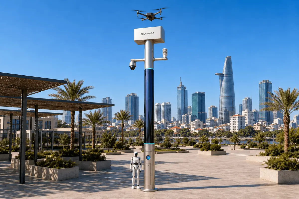
A City AI Pole is a non-lighting physical-AI edge node combining local computing, sensing, autonomous drone and ground robot operations, and off-grid energy storage. SOLARTODO Sentinel’s Sky Hub form runs OTATODO on-pole. This proposed Ho Chi Minh City configuration supports a power utility’s flood-season fire-response inspections through coordinated robots, local assessment and human-authorized dispatch.
1. Define the utility task around the river network
For a power utility in Ho Chi Minh City, flood-season fire response begins with establishing what is happening around an asset and whether a crew can approach it. A proposed operating area would connect utility compounds, canal-side access routes and infrastructure perimeters associated with the Saigon River and waterways such as Nhieu Loc–Thi Nghe. Heavy rainfall and tidal effects are documented contributors to the city's flooding. Their relevance here is operational: a route available during routine inspection may require reassessment during an incident. Source: World Bank flood-risk assessment.
The planning problem is slow manual patrol. When an alarm or report suggests smoke near an electrical compound, staff may need to travel, establish a safe observation point, inspect the perimeter and relay findings before the incident lead can decide the next action. Flooded approaches can add uncertainty and repeated travel. These are proposed workflow assumptions for investigation, not measured conditions at a named customer.
This case study therefore presents an illustrative deployment plan using SOLARTODO Sentinel's mature, in-service capabilities; it does not report an installed Ho Chi Minh City fleet or achieved savings. Its primary field resource is a ground robot, supported by edge computing and selective drone observation. The buyer's objective is to reduce avoidable inspection effort while maintaining accountable incident decisions. Electrical isolation, firefighting and entry into hazardous areas remain with qualified, authorized personnel.
2. Lay out a grid-mesh of independent operating nodes
The proposed grid-mesh is an operational arrangement of independent nodes across utility locations. Here, grid means a geographic service pattern; every Sky Hub remains fully off-grid, with no grid, city or site power connection. Placement would follow asset access, robot routes, safe drone operating areas and communications availability. Canal crossings and gates matter more than a uniform spacing rule because neighboring locations on a map may have very different ground access.
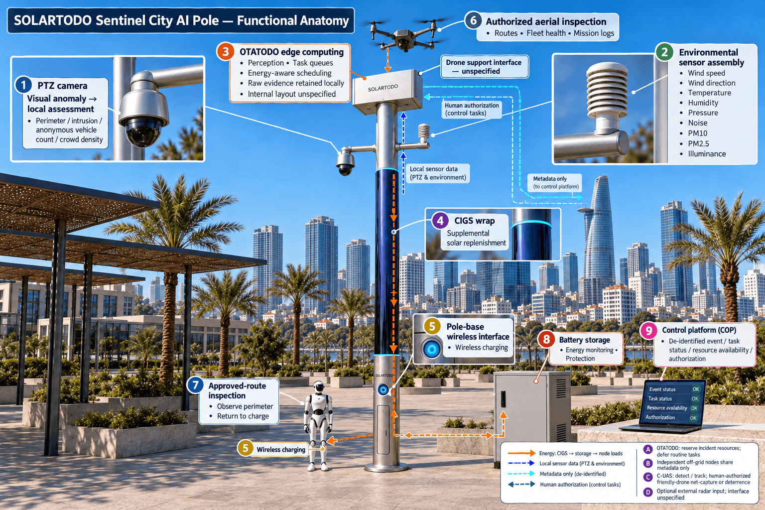
Each node is a PURE smart pole with no lighting system. Its integrated functions comprise the pole platform, drone operations, automated drone battery exchange, drone operations management, ground robot operations, security sensing, environmental monitoring, edge AI computing and human-authorized C-UAS coordination. OTATODO schedules these functions locally. The proposed configuration emphasizes compute resources for robot task management, camera perception, incident prioritization and energy-aware scheduling rather than treating every module as continuously active.
A service robot patrols approved routes, responds to alarms, inspects accessible observation points and returns to the pole base for wireless charging. A drone adds an aerial view where ground inspection cannot answer the incident lead's question. Its multi-bay battery magazine performs automated rear-service exchanges after landing, enabling consecutive sorties when charged packs, weather and operating permissions allow. Route planning, charge/swap state transitions, task queues, fleet health and mission logs support operation without an operator physically stationed at the node.
Final placement requires engineering confirmation of foundations, flood exposure, charging access, maintenance access and separation from electrical hazards. Mesh coordination shares de-identified task and status metadata; neighboring nodes do not exchange raw video or sensor data.
3. Run a robot-first detect, assess and respond loop
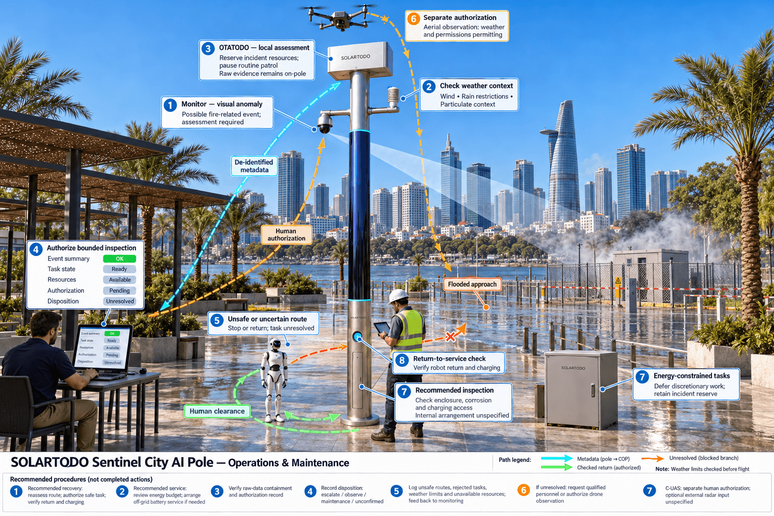
An illustrative incident starts when the PTZ camera identifies a visual anomaly near a utility perimeter. On-pole perception produces an event for assessment rather than declaring a confirmed electrical fire. Environmental readings provide context: wind speed, wind direction, temperature, humidity, atmospheric pressure, noise, PM10, PM2.5 and illuminance. Particulate changes alone do not establish combustion, and this configuration does not imply a dedicated thermal or certified fire-detection instrument.
The common-operating-picture command view connects sensing, authorized assessment and response, edge-compute scheduling, and field operations and maintenance. It presents de-identified event summaries, task states, resource availability and authorization records. Raw video and sensor data stay on the originating pole and are processed locally. Local personnel can examine retained evidence under controlled on-pole access; remote decisions use permitted metadata together with established incident communications.
After a supervisor authorizes an inspection, OTATODO assigns the robot an approved observation route. The robot checks accessible approaches and perimeter conditions from outside the hazard boundary. It does not enter floodwater, approach suspected energized equipment or undertake firefighting. If the route becomes unsafe or uncertain, it stops or returns according to its operating rules and reports an unresolved inspection task. The incident lead can then request qualified personnel or authorize a drone observation within applicable permissions and weather limits.
Edge scheduling reserves resources for the active incident, defers routine patrol work and records why a task was accepted, paused or rejected. The robot returns for wireless charging when its task ends. Closure requires a human disposition: escalate, continue observation, dispatch maintenance or record the event as unconfirmed. Automation supports that decision without silently closing a potentially serious alarm.
4. Engineer energy and data boundaries for flood season
Sky Hub uses battery storage with supplemental solar replenishment. The proposed pole carries approximately 15 m² of flexible CIGS thin-film wrapped through 360° around a roughly 8 m tall, 0.6 m-wide cylindrical body, with approximately 2.4–2.7 kWp nameplate capacity. That nameplate figure is not simultaneous operating output: direct sunlight reaches the cylinder's sun-facing projection rather than its entire wrapped surface.
As a reference for a high-irradiance region such as Saudi Arabia, realistic clear-sky production is approximately 0.8–1.1 kW DC peak and 6–9 kWh per day, with peaks potentially occurring mid-morning or afternoon rather than noon. Those figures are not a Ho Chi Minh City forecast. Local shading, cloud cover, rainfall, temperature and seasonal conditions require a separate yield assessment. The deployment must not assume that solar replenishment alone can sustain unrestricted drone and robot activity.
Storage in the 5–20 kWh class buffers computing, sensing, communications, charging and flight-support loads. Capacity selection requires a complete energy budget, usable reserve assumptions and an off-grid battery-service plan for prolonged low generation. OTATODO schedules high-power tasks by duty cycle, protects incident reserves and defers discretionary activity when energy is constrained. Engineering must also establish flood-safe component elevations, enclosure requirements, corrosion protection and service procedures.
Data governance follows the same principle of explicit boundaries. Raw video and sensor data remain on-pole; only de-identified event and status metadata may leave. The design is PDPL/LGPD-oriented through local processing, without claiming certification or established compliance. Vietnamese legal requirements, retention periods, access permissions and incident-record responsibilities require separate review before deployment.
5. Evaluate operating expense through auditable work records
The proposed business case measures operating expense through labor time, repeat visits and maintenance effort. It should not assume that every robot inspection eliminates a crew dispatch: a confirmed fire, electrical hazard or ambiguous observation may require immediate attendance. The useful comparison is whether local inspection removes avoidable travel and improves the information available before qualified responders arrive.
Before deployment, the utility should establish a baseline for comparable patrol tasks: travel time, observation time, staff involved, repeat attendance and record preparation. Evaluation then compares those activities with robot supervision, event review, node maintenance, cleaning, battery servicing and connectivity administration. Routine inspections and incident responses should be analyzed separately so that a quiet evaluation period does not create misleading savings.
The illustrative calculations below provide recomputable planning inputs, not local statistics or product performance. Buyer-defined targets can include lower staff-hours per completed routine inspection, fewer repeat verification visits and reduced reporting effort. Records should also capture rejected tasks, unsafe routes, weather restrictions and unavailable resources. These exceptions explain whether an apparent labor reduction reflects useful automation or unfinished work.
Acceptance should require traceable authorization records, successful robot return and charging checks, verified raw-data containment, and review of the seasonal energy budget. C-UAS remains a separate, permission-controlled capability: the node detects and tracks an unauthorized drone and, with human authorization, commands its own friendly drone for soft aerial net-capture or close-approach deterrence. Radar is only an optional partner-sensor input. The procurement decision should follow engineering confirmation and measured workflow evidence; no achieved savings, deployment quantity or coverage claim is implied.
System Configuration
| Parameter | Configuration |
|---|---|
| Pole and operating system | PURE non-lighting Sky Hub physical-AI edge node running OTATODO; no lighting system |
| Edge computing and data | On-pole inference and workload scheduling; raw video and sensor data retained locally; de-identified event/status metadata export only |
| Ground robot operations | Service robot with approved patrol routes, alarm-response inspection, air-ground coordination and pole-base wireless charging |
| Drone operations | Autonomous launch, patrol, inspection, return and redeployment; multi-bay automated rear-service battery exchange |
| Security and environmental sensing | PTZ with anonymous vehicle count, crowd density, intrusion and perimeter awareness; nine environmental measurements |
| Off-grid energy | Approximately 15 m² wrapped flexible CIGS, 2.4–2.7 kWp nameplate; 5–20 kWh-class storage, subject to energy-budget confirmation |
| C-UAS coordination | Detection, tracking and human-authorized friendly-drone soft net-capture or close-approach deterrence; optional external radar input only |
How It Works
- On-pole perception flags a possible fire-related anomaly and retains raw evidence locally.
- Edge computing correlates local observations and publishes a de-identified assessment summary.
- A human supervisor authorizes a bounded robot inspection through the COP.
- OTATODO schedules the robot and any separately authorized drone observation within safety and energy limits.
- The incident lead records escalation or closure while local logs retain evidence and task history.
Planning Assumptions (Indicative)
Illustrative planning inputs a buyer can recompute — target metrics, not achieved results. Subject to final engineering confirmation.
| Metric | Planning assumption | Indicative value |
|---|---|---|
| Baseline routine inspection labor | ILLUSTRATIVE ONLY: 20 rounds per month, 2 staff per round and 30 minutes per staff member. | 20 × 2 × 30 ÷ 60 = 20 staff-hours/month |
| Robot-supported review labor | ILLUSTRATIVE ONLY: the same 20 routine rounds require 1 reviewer for 10 minutes each; validate task equivalence. | 20 × 1 × 10 ÷ 60 = 3.33 staff-hours/month |
| Additional node service labor | ILLUSTRATIVE ONLY: 4 incremental service visits per month require 1 technician for 60 minutes, including travel. | 4 × 1 × 60 ÷ 60 = 4 staff-hours/month |
| Net routine labor opportunity | ILLUSTRATIVE ONLY: subtract 3.33 review hours and 4 service hours from 20 baseline hours; exclude emergency attendance. | 20 − 3.33 − 4 = 12.67 potential staff-hours/month before other operating overhead |
| Incident-record preparation | ILLUSTRATIVE ONLY: 8 records per month take 15 minutes manually versus 10 minutes with structured event logs; evaluate separately. | 8 × (15 − 10) ÷ 60 = 0.67 potential staff-hours/month |
Deployed Equipment
- Sky Hub non-lighting pole with wrapped flexible CIGS solar replenishment
- Battery storage cabinet with energy monitoring and protection
- On-pole edge-compute enclosure running OTATODO
- PTZ camera and nine-measurement environmental sensor assembly
- Service robot and pole-base wireless charging interface
- Patrol drone with multi-bay automated rear-service battery magazine
- Communications equipment for de-identified event and status metadata
Frequently Asked Questions
Is this an existing Ho Chi Minh City deployment?
This article describes a proposed, illustrative Ho Chi Minh City configuration using SOLARTODO Sentinel's mature, in-service capabilities. It does not identify a local customer, installation count or achieved result. Site placement, operating permissions, energy sizing and acceptance criteria remain subject to final engineering confirmation and buyer evaluation.
Does grid-mesh mean the poles use utility electricity?
Grid-mesh describes the geographic arrangement and coordinated task coverage of independent nodes. Each pole is fully off-grid and uses battery storage plus on-pole CIGS solar replenishment, without grid, city or site power. Seasonal energy planning must establish task limits, reserves and battery servicing for extended periods of low generation.
What can the robot do during a suspected fire?
The robot can perform an authorized inspection along approved routes, observe accessible perimeter conditions, support alarm assessment and coordinate with aerial observation. It remains outside defined hazards and returns for wireless charging. It does not replace firefighters, perform electrical isolation or receive permission to enter unsafe floodwater merely because an alarm exists.
What information reaches the remote command view?
The remote COP receives only de-identified event and status metadata, including task progress, resource availability and authorization records. Raw video and sensor data stay on the originating pole for local processing. Local evidence access, retention and audit procedures require explicit governance; PDPL/LGPD-oriented design does not establish certification or Vietnamese legal compliance.
How should the utility assess operating-cost value?
The utility should compare equivalent completed tasks using staff-hours, repeat attendance and record-preparation effort, then include supervision, maintenance, cleaning, battery service and communications overhead. Emergency attendance should be assessed separately. The supplied arithmetic is hypothetical planning material; meaningful savings claims require measured operating records and confirmation that required inspection work was actually completed.
How are drone operations and C-UAS interventions controlled?
Drone management handles routes, charge/swap states, queued tasks, fleet health and mission logs, while operating permissions and weather limits govern dispatch. C-UAS intervention requires human authorization and is limited to friendly-drone soft aerial net-capture or close-approach deterrence. Radar is not built into the pole; optional partner sensors may supply detection inputs.
Explore Further
- City AI Pole / smart streetlight product line
- More smart-city deployment cases
- Talk to our engineering team
Planning a similar physical-AI deployment for streets, campuses or public spaces? Request an engineering consultation