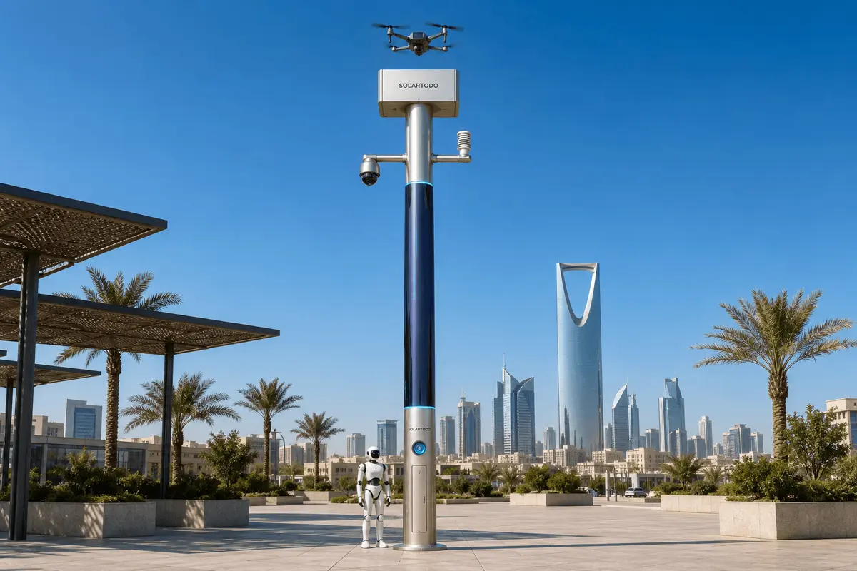
A City AI Pole is a non-lighting physical-AI edge node that hosts sensing, compute, energy storage, drone operations and robot coordination on one fully off-grid urban pole. In this Athens proposal, SOLARTODO Sentinel Sky Hub monitors transport corridors, processes raw data locally, and dispatches authorized low-altitude inspection tasks from the pole.
1. Operating Context
Athens is a transport city shaped by dense road corridors, rail interfaces, coastal logistics and a river-network of engineered channels such as the Kifisos and Ilisos corridors. For a transport authority, the operational issue is not a lack of cameras in general; it is the delay between a field anomaly and a qualified inspection. Manual patrols can be slow when teams must cross congested districts, reach bridge underpasses, inspect drainage edges, or verify damage after wind, rain and coastal surge events. This proposed single-pilot configuration places one SOLARTODO Sentinel Sky Hub at a priority transport node where road, rail, drainage and service-access routes converge. The objective is to evaluate whether an off-grid physical-AI edge node can compress response time from initial observation to actionable field confirmation. The deployment is intentionally framed as an operations plan, subject to final engineering confirmation, rather than a claimed citywide rollout. Sky Hub is not a smart street asset for illumination and includes no lighting system. It is a PURE smart pole form: sensing, edge compute, battery-backed energy, drone operations and ground robot operations in one pole body. The seasonal trigger is typhoon-season readiness used as an operational discipline: Athens is not positioned as a tropical-typhoon city, but the transport authority can adopt the same pre-season checklist mindset for Mediterranean severe storms, sudden drainage overload, high wind, heat-stressed infrastructure and coastal transport disruption.
2. Single-Pilot Node Plan
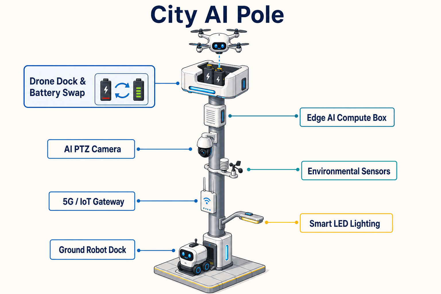
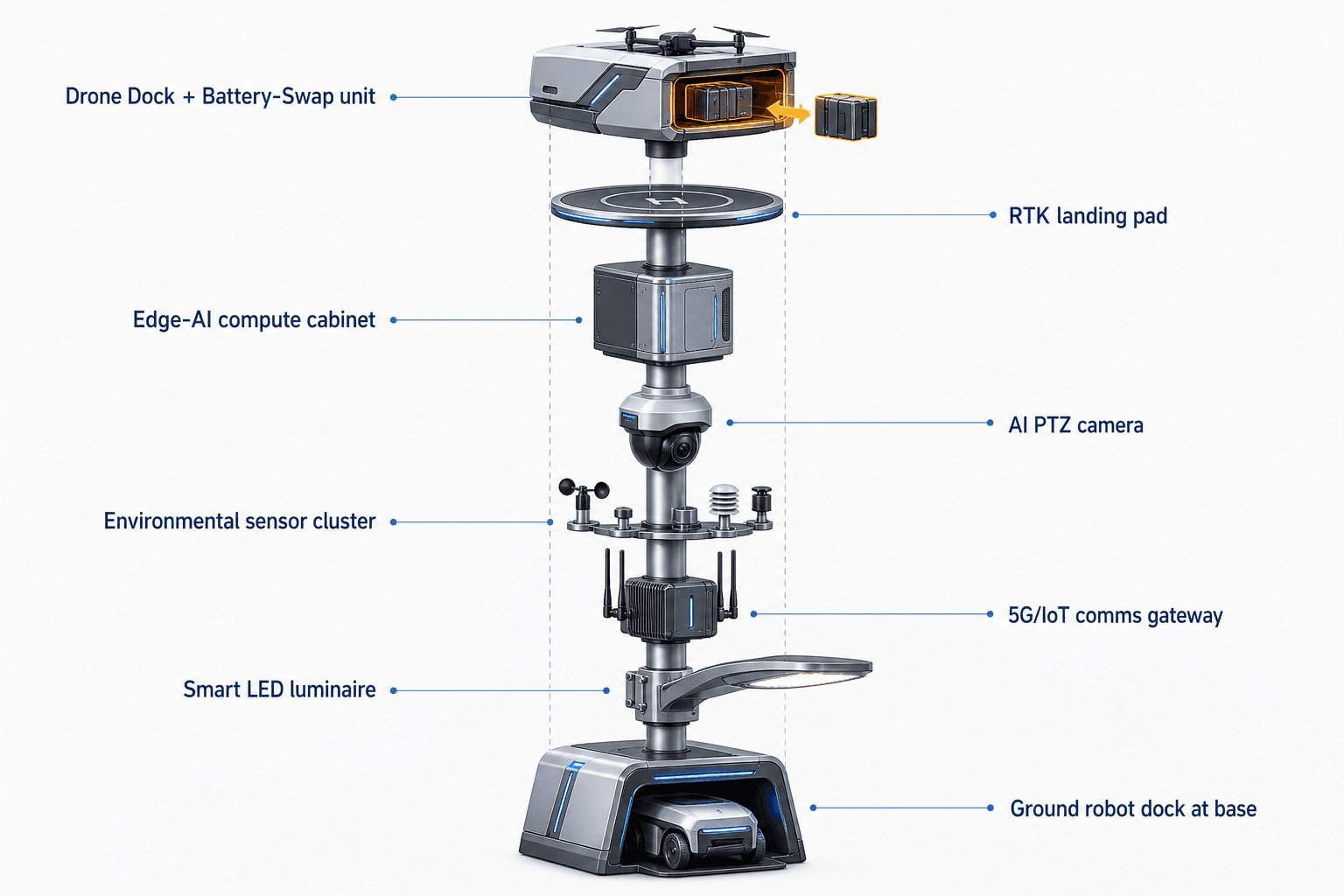
The pilot node is proposed for a transport authority location where slow manual patrol creates the highest operational drag: a bridge-and-channel approach, a depot perimeter, a port-adjacent access road, or a strategic interchange with difficult pedestrian inspection access. The Sky Hub pole operates fully off-grid, using battery storage plus approximately 15 m² of 360° wrapped flexible CIGS thin-film solar replenishment over a vertical cylindrical body around 8 m tall and about 0.6 m wide. The wrap represents roughly 2.4-2.7 kWp nameplate, but the planning model does not treat the full wrap as simultaneous sun-facing generation. In high-irradiance reference conditions, realistic clear-sky output is roughly 0.8-1.1 kW DC peak, usually peaking mid-morning or mid-afternoon rather than noon, and about 6-9 kWh per day. Athens engineering would still require local solar, wind, shading, salt-air and structural review. The solar layer is a supplemental replenishment layer for a battery-backed micro-station, not a claim of unlimited self-sufficiency. High-power drone and robot tasks are buffered by 5-20 kWh-class storage and scheduled by duty cycle. This makes the node suitable for transport corridors where site power access is difficult, delayed, politically sensitive or undesirable. It also keeps the pilot narrow: one node, one authority workflow, one common-operating-picture command view and one response-time evaluation path.
3. PTZ-Led Detection
The module focus is the PTZ camera because the first operational gap is situational confirmation, not fleet scale. The on-pole PTZ camera runs local perception for anonymous vehicle count, crowd density, intrusion and perimeter awareness around the selected transport asset. It can patrol preset views such as drainage mouths, bridge bearings, service gates, embankment edges, queue spillback points and restricted access zones. The camera is not described here as a face-recognition or licence-plate-recognition system. Raw video and sensor data stay on the pole and are processed locally by a Jetson-class edge module in the inference cabinet. Only de-identified event or status metadata may leave the pole for the authority dashboard, subject to policy. The node combines the PTZ view with the nine-in-one environmental package: wind speed, wind direction, temperature, humidity, atmospheric pressure, noise, PM10, PM2.5 and illuminance. During typhoon-season-style readiness drills, the node can watch for high-wind thresholds, sudden visibility reduction, crowding near closed access points, unusual vehicle stoppage, or intrusion into a restricted inspection zone. OTATODO schedules compute workloads on-pole, balancing perception, energy state, drone task readiness and local storage. The command view presents sensing, authorized assessment and field action as a single COP workflow so the authority is not forced to jump between disconnected sensor, drone and maintenance screens.
4. Battery-Swap Inspection Loop
Battery swap is the center of the Athens use case because low-altitude inspection often fails operationally when every flight becomes a manual logistics event. In this proposed Sky Hub configuration, the drone lands at the pole, a rear-service multi-bay battery magazine performs an automated battery exchange, and the aircraft relaunches with a charged pack. Multiple bays support several consecutive sorties, with the number of cycles governed by energy state, weather limits, airspace authorization, storage reserve and mission priority. The transport authority can use the drone for short low-altitude inspections: checking a suspected channel blockage, photographing a bridge expansion joint after a vibration alert, reviewing overhead conflict near a service yard, or verifying whether a restricted corridor is clear after a storm warning. No operator needs to stand at the pole for routine launch, return, swap and redeployment. Drone operations management covers route planning, charge and swap state machine, task queueing, fleet health and mission logs. The workflow remains human-in-the-loop: the node can recommend a sortie, but the authority authorizes response based on local procedure. Ground robot operations extend the loop at surface level. A humanoid or service robot can perform patrol, alarm response, inspection and air-ground coordination, then return to the pole base for wireless charging. Together, PTZ, drone and robot create a practical inspect-confirm-maintain chain for hard-to-reach transport assets.
5. KPI Evaluation And Governance
The KPI framing is response time: how quickly the authority can move from an on-pole alert to a qualified field assessment and a recorded decision. The pilot should not claim achieved reductions before measurement. Instead, it should define target evaluation windows: alert triage time, human authorization time, drone dispatch time, inspection capture time, robot handoff time, maintenance-ticket creation time and event-review completion time. The response model follows the operations loop of sensing, authorized assessment and response, edge-compute scheduling, then field operations and maintenance. C-UAS coordination is included as an authority-bound safety workflow, not an autonomous enforcement promise. The pole may detect and track an unauthorized drone using its own sensing and optional partner-sensor inputs; radar is not built into the pole. With human authorization, the node can command its friendly drone for non-lethal soft aerial net-capture or close-approach deterrence under approved rules. It does not shoot down, jam, destroy or autonomously attack anything. Data governance is designed for local processing and PDPL-LGPD-oriented controls: raw video and sensor data remain on the pole by default, local storage and inference support auditability, and exported information is limited to de-identified events, status metadata and mission logs. For Athens, this gives the transport authority a narrow, measurable way to evaluate physical-AI operations without pretending that one node solves every city problem.
System Configuration
| Parameter | Configuration |
|---|---|
| Deployment mode | Single-pilot Sky Hub node for one priority Athens transport corridor or asset cluster, subject to final engineering confirmation |
| Pole category | PURE non-lighting city AI pole / physical-AI urban edge node with no lighting system |
| Energy system | Fully off-grid battery-backed micro-station with ~15 m² 360° wrapped flexible CIGS replenishment and 5-20 kWh-class storage planning range |
| Camera | AI PTZ camera for local patrol views, anonymous vehicle count, crowd density, intrusion and perimeter awareness |
| Edge AI compute | Jetson-class on-pole inference module running local perception, workload scheduling and event metadata generation |
| Drone operations | Autonomous launch, route tasking, return, multi-bay battery hot-swap and relaunch management without an operator at the pole |
| Robot interface | Ground robot patrol and inspection coordination with return-to-base wireless charging at the pole base |
How It Works
- On-pole PTZ camera flags an anomaly at a bridge, drainage or restricted transport access point.
- Edge AI classifies the event locally and creates a de-identified alert with severity, location and confidence context.
- The transport authority reviews the COP prompt and authorizes a drone or robot response under local procedure.
- The drone launches, performs low-altitude inspection, returns to the pole and uses automated battery hot-swap if another sortie is needed.
- OTATODO records event metadata, energy state, mission log and follow-up status for response-time evaluation.
Planning Assumptions (Indicative)
Illustrative planning inputs a buyer can recompute — target metrics, not achieved results. Subject to final engineering confirmation.
| Metric | Planning assumption | Indicative value |
|---|---|---|
| Inspection labor | Planning target for low-altitude drone inspection to replace selected manual verification trips after PTZ alerts | ~3-5 patrol equivalents per week automated for evaluation |
| Response-time window | Target planning window from on-pole PTZ anomaly flag to authorized drone dispatch under normal pilot conditions | ~5-10 minutes target, not an achieved result |
| Sortie continuity | Battery magazine supports consecutive short inspection sorties before manual service, governed by weather, reserve energy and mission priority | ~3-6 short sorties per readiness cycle for planning |
| Event review | Local processing reduces raw footage review by exporting only de-identified event records and mission status metadata | ~10-20 event summaries per week for pilot review |
| Manual escalation | Human operator remains responsible for authorization and can escalate only validated anomalies to field maintenance teams | ~1-2 escalation drills per week during evaluation |
Deployed Equipment
- SOLARTODO Sentinel Sky Hub pole-form edge node
- 360° wrapped flexible CIGS solar replenishment layer
- Battery-backed off-grid energy cabinet with power-management controls
- AI PTZ camera and local perception pipeline
- Nine-in-one environmental monitoring package
- Drone landing, service and multi-bay battery-swap module
- Ground robot wireless charging interface
- COP command-view software running OTATODO edge workflows
Frequently Asked Questions
Is Sky Hub a smart streetlight for Athens transport corridors?
No. Sky Hub is a PURE smart pole and includes no lighting system. In this proposed Athens transport-authority use case, the pole is used as a physical-AI edge node for sensing, local compute, drone operations, robot coordination and off-grid energy management. It should be evaluated as city-ai-pole infrastructure, not as a lighting replacement.
Does the node require grid, city or site power?
No. The proposed Sky Hub configuration is designed as a fully off-grid battery-backed micro-station with on-pole CIGS solar replenishment. The solar wrap is a supplemental replenishment layer and not an unlimited self-sufficiency claim. Drone and robot workloads are buffered by storage and scheduled by duty cycle, with final sizing subject to site engineering.
Why is battery swap important for low-altitude inspection?
Battery swap turns the drone from a manually serviced inspection accessory into part of an operations loop. After a short inspection sortie, the drone can land, receive a charged pack from the rear-service multi-bay magazine, and relaunch for another task. That supports response-time evaluation because the authority measures dispatch and confirmation workflow, not only image quality.
What data leaves the pole during the pilot?
The default design keeps raw video and sensor data on the pole, where local inference and event processing occur. What may leave the node is limited to de-identified event metadata, status updates, energy state, mission logs and operator-approved records. This is PDPL-LGPD-oriented local-processing design language, not a claim of formal certification.
Can the system identify faces or read licence plates?
Those are not claimed as active deployed capabilities in this case study. The PTZ and edge AI workflow is described for anonymous vehicle count, crowd density, intrusion and perimeter awareness. The purpose is to help a transport authority validate anomalies and dispatch inspection resources while keeping raw data local by default.
How is Counter-UAS handled in this Athens scenario?
Counter-UAS coordination is human-authorized and non-lethal. The pole can detect and track an unauthorized drone, including through optional partner-sensor input where engineered, and can command its friendly drone for soft aerial net-capture or close-approach deterrence if authorized. The workflow does not include shoot-down, jamming, denial or autonomous attack.
What should the transport authority measure during the single pilot?
The useful measures are operational rather than promotional: alert-to-review time, review-to-authorization time, drone dispatch time, inspection completion time, battery-swap readiness, robot handoff time, event-summary quality and maintenance-ticket clarity. These are target evaluation metrics for the pilot, not claimed achieved results.
How does the severe-weather trigger apply to Athens?
The plan uses typhoon-season discipline as a readiness pattern: pre-check energy reserves, patrol views, drone readiness, battery-swap state, drainage watch points and escalation rules before severe weather periods. Athens conditions require local engineering review, but the operating method is transferable to Mediterranean storms, high winds, flooding risk and transport-disruption events.
Explore Further
- City AI Pole / smart streetlight product line
- More smart-city deployment cases
- Talk to our engineering team
Planning a similar physical-AI deployment for streets, campuses or public spaces? Request an engineering consultation