Summary
Budapest’s riverfront and historic districts require a proposed 90-node SOLARTODO Sentinel network with approximately 30 m spacing, local data processing, and carefully scheduled robotic operations. This guide assesses off-grid configuration and siting.
Key Takeaways
A proposed 90-node Budapest network should prioritize heritage permissions, winter operating reserves, and locally processed intelligence, with approximately 30 m spacing validated individually against access constraints.
- Approximately 90 units would serve selected corridors and facilities; this is a proposed configuration, not a reported Budapest installation.
- 90 positions at 30 m intervals create 2.67 km between endpoints in one uninterrupted line, not citywide coverage.
- The supplied architecture supports 5–20 kWh-class storage per node, selected through site-specific load and seasonal analysis.
- Budapest recorded 31 frosty days in 2024, according to KSH; cold-weather battery management belongs in procurement requirements.
- Each node provides 9 environmental measurements, alongside anonymous vehicle counts, crowd density, intrusion detection, and perimeter awareness.
- UNESCO lists 476 ha within Budapest’s World Heritage property; protected settings require location-specific assessment.
- Drone service and robot operations share 1 common operating picture, while counter-UAS intervention requires explicit human authorization.
Budapest’s Danube Banks, Buda Slopes and Heritage Streets
Budapest’s 476 ha World Heritage property makes permission, pedestrian access, and protected urban settings central selection criteria for a proposed 90-node physical-AI network.
According to UNESCO’s Budapest listing (1987; boundary modification 2002), the protected property covers 476 ha, with a 501 ha buffer zone. UNESCO states, “It is one of the world's outstanding urban landscapes.” Its description distinguishes Buda’s elevated right-bank terrain from Pest’s flatter left bank. These conditions favor separate engineering schedules for hillside access, inner-city streets, and riverbank locations rather than one standard foundation drawing. UNESCO
According to the Hungarian Central Statistical Office, KSH (2026), Budapest’s 2024 mean temperature was 14.4°C. According to the same table, 2024 precipitation totaled 428 mm, compared with 714 mm in 2023. KSH also records 31 frosty days and 67 heat days in 2024; these annual observations are not equipment qualification limits. Budapest is inland, so freshwater flood exposure, winter freezing, summer heat, and urban dirt deserve greater attention than marine salt exposure. KSH meteorological data
Municipal and district authorities, public-space managers, heritage reviewers, and facility owners are relevant buyer and approval groups. Suitable demand comes from riverfront assets, campuses, industrial estates, and controlled infrastructure perimeters needing inspection and incident coordination. Narrow historic streets constrain lifting access and robot movement, while tram infrastructure requires surveyed clearances. Riverbank sites additionally need flood-level assessment and a recovery route that remains accessible during restrictions.
Recommended Technical Configuration
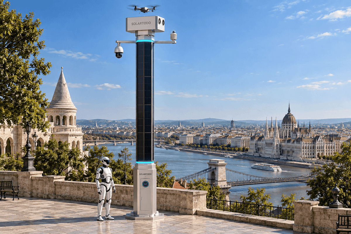
A typical 90-unit deployment of this scale would use Sky Hub pole-form nodes at approximately 30 m intervals within selected Budapest corridors and controlled facilities.
The appropriate category is the SOLARTODO Sentinel City AI Pole, a physical-AI edge station integrating sensing, computing, autonomous drone service, and ground robot support. Its Sky Hub configuration fits applications needing field action as well as observation. No dimensional size-class table is supplied, so this guide assigns no unsupported height, weight, foundation size, or structural rating. See the SOLARTODO urban edge solutions for product scope.
Allocate by operating environment
Use a proposed 3-package, 30-node procurement structure to separate riverbank, heritage-adjacent, and controlled-facility requirements. This is an administrative recommendation, not evidence that those locations are approved or that equal allocation is optimal. Each package needs a surveyed position register covering access, communications, privacy boundaries, flood exposure, and task demand. Drone and robot fleet quantities should follow mission concurrency and service-radius analysis rather than assuming one aircraft and one robot per pole.
Connect sensing to authorized field work
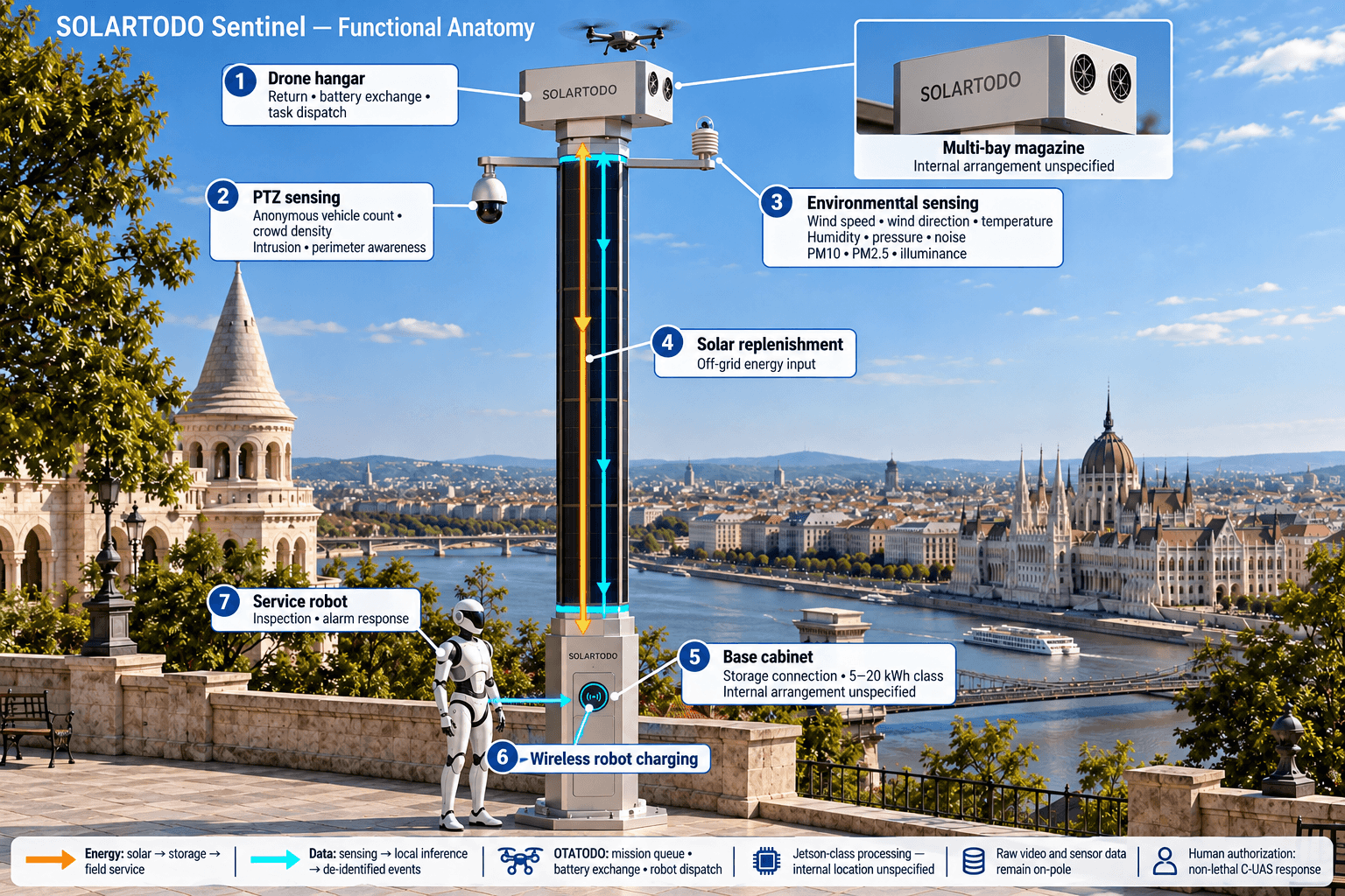
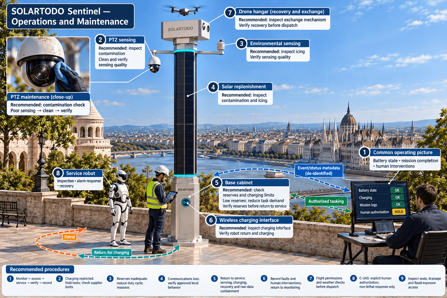
OTATODO schedules local inference, inspection tasks, aircraft battery exchange, and robot charging. Autonomous drone operations cover departure, patrol, return, automated pack replacement through a multi-bay magazine, and subsequent task dispatch. Service robots perform inspection and alarm response, coordinate with aircraft, and return for wireless charging. Supervisors receive de-identified events and equipment status in a common operating picture; raw video and sensor data remain on their originating pole.
Counter-UAS coordination combines detection and tracking with human-authorized tasking of a friendly aircraft for soft aerial net-capture or close-approach deterrence. These are non-lethal response workflows subject to competent-authority permissions and an approved operating procedure. Radar, if required, supplies optional partner-sensor input and is not integrated pole hardware.
Technical Specifications
The proposed 90-node configuration combines nine environmental measurements, local AI processing, automated drone battery exchange, and 5–20 kWh-class storage, with final selections subject to engineering confirmation.
- Quantity and layout: approximately 90 Sky Hub nodes across selected Budapest locations, with approximately 30 m spacing where surveys support it.
- Compute: Jetson-class Orin- or Thor-class edge processing; select throughput and thermal capacity against concurrent workloads.
- Perception: PTZ sensing for anonymous vehicle counts, crowd density, intrusion, and perimeter awareness; identity recognition is outside this configuration.
- Environment: wind speed, wind direction, temperature, humidity, atmospheric pressure, noise, PM10, PM2.5, and illuminance—9 measurements.
- Field service: autonomous drone mission management, multi-bay battery exchange, robot task dispatch, and wireless robot charging.
- Energy: fully off-grid operation using on-pole monocrystalline solar replenishment and 5–20 kWh-class battery storage; mission demand is scheduled against available reserves.
- Replenishment reference: supplied product data gives approximately 2.8–3.2 kWp nameplate, with roughly 1.0–1.3 kW DC clear-sky peak and 7–10 kWh/day under high-irradiance conditions. These are not Budapest yield guarantees.
- Data boundary: raw video and sensor data stay on-pole; only de-identified event and status metadata may leave.
According to IEC (1989, amended 1999 and 2013), IEC 60529 defines enclosure protection classifications. Procurement should require enclosure test evidence suitable for the surveyed conditions, without inferring an IP rating from product category. Separately confirm structural calculations, battery safety documentation, cold-weather charging limits, and the applicable Hungarian requirements. No certification or operating temperature rating is established by the supplied brief. IEC 60529
Implementation Approach
A proposed 90-node Budapest program should pass three approval gates: surveyed siting, authorized operating procedures, and acceptance testing that includes winter reserves and data boundaries.
Resolve permissions before production release
Prepare the position register, utility surveys, geotechnical scope, pedestrian access plan, and communications assessment before freezing procurement. Foundation design must address Buda slopes separately from Pest locations, with flood exposure assessed for riverbank positions. Packaging and assembly strategy should match restricted delivery access; partly assembled shipping is an option, not an assumed requirement. Retain access for battery servicing and robotic recovery.
According to EASA (2026 access), flight beyond visual line of sight is an example of a specific-category operation. EASA states, “The Operations Manual together with other applicable documents are submitted to the NAA”. Hungarian aviation-authority engagement and geographical-zone checks must therefore precede relevant flight operations; product autonomy does not grant airspace permission. Establish the applicable authorization or declaration route for each mission profile. EASA specific-category guidance
Sequence installation around access and acceptance
An illustrative planning allowance is 4–6 weeks for surveys and scope definition, followed by supplier-confirmed manufacture and freight, then 4–8 weeks for staged site work and commissioning. These are editorial planning assumptions, not quoted delivery commitments; permission reviews can dominate the schedule. Commission foundations, sensing zones, local inference, communications, charging, and robotic recovery progressively. Acceptance should verify that raw-data export is blocked and that communications loss produces the approved local behavior.
Expected Performance & ROI
For a proposed 90-node network, economic value should be evaluated through inspection productivity, response coordination, and lifecycle cost rather than an unsupported fixed payback claim.
A transparent productivity scenario assumes 1 scheduled inspection per node per day, or 90 tasks daily, when mission permissions and energy reserves permit. If accepted automation avoids 10 minutes of routine manual work per task, the gross opportunity is 15 staff-hours per day. Those figures are arithmetic assumptions, not measured Budapest outcomes. Subtract supervision, exception handling, maintenance, weather cancellations, and travel that still remains before valuing labor savings.
Use annual net benefit = verified avoided operating cost − incremental operating cost. Simple payback equals installed capital divided by positive annual net benefit; a procurement decision should also examine discounted lifecycle cost. Compare like-for-like inspection scope and service availability over a proposed 10-year evaluation horizon, with battery replacement and software support explicitly budgeted. No public benchmark establishes a reliable payback period for this exact configuration.
Test the winter duty cycle
At an illustrative 100 W continuous base load, one node consumes 2.4 kWh/day before field missions. A 20 kWh battery at 80% assumed usable capacity provides about 6.7 days at that base load before conversion losses, heating, aging, or drone and robot demand. Storage buffers deficits but does not generate replacement energy. If seasonal replenishment cannot sustain the duty cycle, reduce task demand or revise the engineered configuration before acceptance.
According to the European Commission Joint Research Centre, JRC (2026 access), PVGIS provides hourly solar and weather information for location-specific assessment. Model Budapest at 47.5° N, 19.04° E, with actual obstructions and separate solar orientations, rather than transferring high-irradiance reference production. This energy check supports the field-service specification; the buying decision remains centered on useful inspections and response capacity. JRC PVGIS
Results and Impact
Acceptance for a proposed 90-node Budapest network should measure completed inspections, reserve adequacy, recovery reliability, and raw-data containment, with targets agreed before procurement award.
Record mission completion, false-alert frequency, response time, battery state, and human interventions by operating zone. Separate aircraft availability from permission to fly and from weather-related cancellations. Report productivity against an agreed manual baseline, with no citywide coverage or deployment claim implied by the proposed quantity.
Comparison Table
Across the proposed 90 positions, procurement should compare task coverage and operational dependencies between integrated physical-AI nodes, observation-only stations, and manually delivered inspection services.
| Decision factor | SOLARTODO Sentinel City AI Pole | Observation-only station | Manual inspection service |
|---|---|---|---|
| Proposed scope | Approximately 90 nodes | Match surveyed observation points | Match inspection routes |
| Field action | Drone and ground robot workflows | Requires separate response resources | Staff travel and attendance |
| Environmental scope | 9 measurements | Depends on specified sensors | Depends on instruments carried |
| Data architecture | Raw data stays on each pole | Must be specified contractually | Must be specified contractually |
| Energy | Off-grid; 5–20 kWh-class storage | Design-specific | Vehicle and equipment dependent |
| Main Budapest constraint | Permissions, winter reserves, recovery access | Siting and response integration | Travel, access, staffing availability |
Pricing & Quotation
A quotation for approximately 90 Budapest nodes should distinguish equipment, delivery, and installed scope, with permissions, civil works, fleet allocation, and acceptance responsibilities explicitly assigned.
SOLARTODO offers three pricing tiers for this product line: FOB Supply (equipment ex-works China), CIF Delivered (including ocean freight and insurance), and EPC Turnkey (fully installed, commissioned, with 1-year warranty). Volume discounts are available for large-scale deployments. Configure your system online for an instant estimate, or request a custom quotation from our engineering team at [email protected].
For contracting, reconcile the quoted FOB label with its ex-works description and specify the actual Incoterms rule and named place. Budapest is inland, so any ocean-freight scope also needs a defined inland delivery leg. No monetary pricing is presented here.
Frequently Asked Questions
These 10 answers address the proposed Budapest configuration, covering technical scope, installation, operating permissions, maintenance, commercial responsibilities, and the evidence needed for investment decisions.
Q1: What configuration is recommended for Budapest?
A typical 90-unit deployment would use SOLARTODO Sentinel City AI Pole nodes in Sky Hub form, with local AI, nine environmental measurements, autonomous drone service, and robot support. Approximately 30 m spacing is a planning input. Storage within the supplied 5–20 kWh class and fleet allocation require site-specific confirmation.
Q2: Does 30 m spacing provide citywide coverage?
No. Ninety positions in one straight line produce 89 gaps, totaling approximately 2.67 km at 30 m spacing. Distributed locations create different coverage patterns. Buildings, Buda’s slopes, river crossings, and restricted airspace affect useful sensing and mission coverage, so buyers need mapped service areas rather than a citywide claim.
Q3: How long would deployment take?
An illustrative schedule allows 4–6 weeks for surveys and definition, then supplier-confirmed manufacture and transport, followed by 4–8 weeks of staged site work and commissioning. These are planning assumptions. Heritage reviews, public-space permissions, aviation authorizations, foundation conditions, and delivery access can extend the overall duration substantially.
Q4: What ROI or payback should buyers expect?
No verified payback period is available for this Budapest configuration. An illustrative 90-task daily schedule saving 10 minutes per task creates 15 gross staff-hours of opportunity, before supervision and maintenance. Buyers should calculate net annual benefit from their own baseline, then compare installed capital and lifecycle costs against that evidence.
Q5: What maintenance is required?
A proposed monthly inspection should review sensing quality, contamination, drainage, seals, battery health, charging interfaces, and aircraft battery-exchange mechanisms. Service frequency must follow supplier instructions and actual conditions. Winter checks should prioritize charging temperature restrictions, reserve capacity, and icing; riverbank locations also need inspection after relevant flood exposure or access restrictions.
Q6: How does Sentinel compare with an observation-only station?
Sentinel combines nine environmental measurements and local perception with dispatched drone and robot work. An observation-only station requires separate resources to inspect or respond. The integrated option therefore adds mission-management and maintenance responsibilities. Budapest buyers should compare completed tasks and total operating cost at equivalent service levels, rather than counting sensors alone.
Q7: What determines EPC quotation scope?
For approximately 90 nodes, EPC scope depends on surveyed foundations, access equipment, transport, communications integration, storage selection, fleet allocation, training, commissioning, and acceptance requirements. The quotation should assign responsibility for permits and authority applications. It should also identify exclusions, the inland delivery destination, and the actual contractual Incoterms rule.
Q8: What warranty is offered?
The stated EPC Turnkey offer includes a 1-year warranty. Buyers should obtain written terms defining commencement, covered components, battery exclusions, software support, labor, freight, and response obligations. The supplied brief establishes no longer warranty, battery cycle guarantee, or availability commitment, so those provisions require explicit agreement before order placement.
Q9: Can autonomous drones operate throughout Budapest?
Autonomous operation is a product capability, but it does not authorize unrestricted flights. EASA identifies beyond-visual-line-of-sight operations as an example of the specific category. The operator must establish the applicable Hungarian authorization route and geographical-zone permissions. Counter-UAS intervention additionally requires competent-authority permission and explicit human authorization for each response.
Q10: How are privacy and data residency handled?
Raw video and sensor data remain on the originating pole; only de-identified event and status metadata may leave. This local-processing design supports data minimization but does not establish GDPR compliance. Under Regulation (EU) 2016/679, the controller must determine lawful processing, retention, access controls, transparency, and whether a data protection impact assessment is required.
References
These 6 public references support Budapest’s climate and heritage context, European aviation and privacy requirements, and engineering assessment methods; they do not verify a local deployment.
- Hungarian Central Statistical Office—KSH (2026): Meteorological data of Hungary and Budapest, including 2023–2024 rainfall, 2024 temperature, and frost and heat-day observations.
- UNESCO World Heritage Centre (1987; modified 2002): Budapest World Heritage listing, including protected area, buffer zone, and Buda–Pest terrain context.
- EASA (2026 access): Specific Category—Civil Drones, covering operational examples, authorization routes, geographical zones, and operator documentation.
- IEC (1989; amendments 1999 and 2013): IEC 60529—Degrees of protection provided by enclosures, the IP classification reference; no product rating is asserted.
- European Commission Joint Research Centre (2026 access): Photovoltaic Geographical Information System, supporting location-specific hourly resource and performance assessment.
- European Parliament and Council (2016): Regulation (EU) 2016/679, including Article 5 data minimization and Article 35 impact-assessment requirements.
Equipment Deployed
- Approximately 90 SOLARTODO Sentinel City AI Pole nodes in Sky Hub form; approximately 30 m spacing subject to survey
- Jetson-class Orin- or Thor-class on-pole computing with OTATODO workload scheduling
- PTZ sensing for anonymous vehicle counts, crowd density, intrusion and perimeter awareness
- Nine environmental measurements: wind speed, wind direction, temperature, humidity, atmospheric pressure, noise, PM10, PM2.5 and illuminance
- Fully off-grid on-pole solar replenishment with 5–20 kWh-class battery storage per node, subject to duty-cycle analysis
- Autonomous drone mission service and multi-bay automated battery exchange; fleet quantities subject to engineering confirmation
- Ground robot dispatch and wireless charging support; robot quantities subject to mission analysis
- Human-authorized, non-lethal counter-UAS coordination; optional partner radar input only
- De-identified event and status communications with raw video and sensor data retained on the originating pole