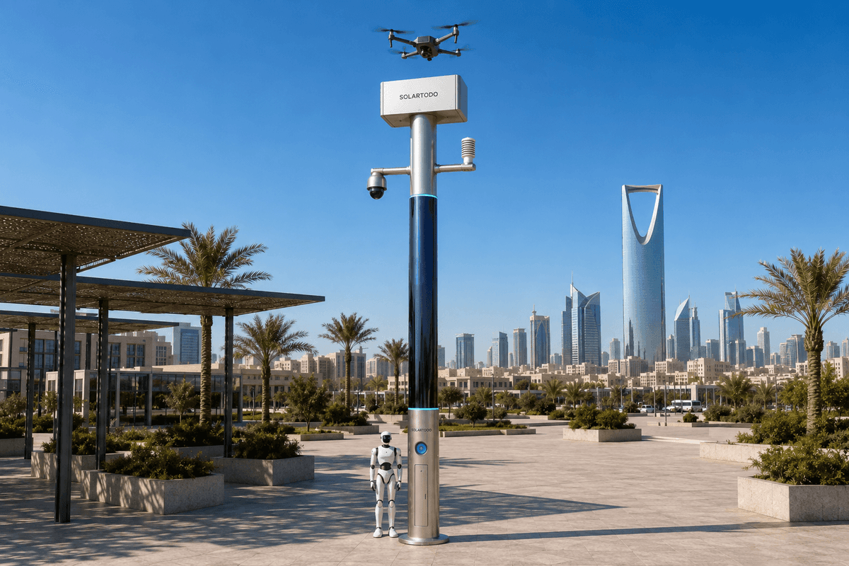
A City AI Pole is a non-lighting physical-AI edge node that combines off-grid power, local sensing, edge compute, drone operations and ground robot support in one pole-form micro-station. In Ho Chi Minh City, SOLARTODO Sentinel Sky Hub is proposed for port border-watch, using local processing and drone tasking to collect de-identified incident evidence faster during flood-season operations.
Port Task And Buyer Context
Ho Chi Minh City’s port environment is a dense operating zone: river channels, logistics parks, container yards, bonded warehouses, industrial roads and flood-prone access edges sit close together. For a park-operator responsible for a port-adjacent industrial area, the daily security problem is not abstract surveillance. It is knowing whether a fence-line anomaly, unauthorized vehicle stop, waterway-side intrusion, or post-storm access issue deserves a response, and having defensible evidence before sending people into the field.
This proposed case frames SOLARTODO Sentinel Sky Hub as a single-pilot deployment for border-watch around a selected port perimeter segment. The goal is to evaluate whether a physical-AI edge-node pole can shorten the time from anomaly detection to usable evidence while keeping raw video and sensor data on the pole. The pole is not a smart streetlight and carries no lighting system. It is a pure smart pole: a city edge node designed for sensing, compute, energy buffering, drone operations, ground robot operations and command coordination.
The seasonal trigger is flood season. Heavy rain, tidal effects and temporary road disruption can make manual patrol slower, riskier and less consistent. In this scenario, the park-operator needs a common operating picture that can show what happened, where it happened, what confidence level the edge node assigned, which drone task was launched, and what response decision a human supervisor authorized. The deployment is proposed as an illustrative configuration subject to final engineering confirmation, not as a claimed completed rollout.
ROI Logic: Response Time Before Scale
The ROI analysis starts with response time because the park-operator’s pain point is evidence collection, not generic monitoring. A conventional patrol workflow may require a guard to travel to the boundary, visually assess the scene, contact a control room, and then request a second action. During flood-season congestion, that sequence can stretch unpredictably. The proposed Sky Hub workflow changes the order: the pole detects and scores an anomaly locally, presents a de-identified event package in the command view, and a human operator authorizes a drone sortie or ground response based on the evidence need.
This does not remove human judgment. It moves the first usable evidence closer to the incident. The KPI should therefore be evaluated as target response-time bands: detection-to-operator review, operator authorization-to-drone launch, drone launch-to-first-evidence, and incident package-to-field dispatch. These are planning metrics for a buyer to measure during site acceptance and operating trials, not achieved results.
The single-pilot mode is deliberately narrow. One node can be positioned at a perimeter choke point, gate-adjacent blind edge, river-facing boundary or critical asset approach. The park-operator can then compare manual patrol logs with node-assisted workflows across similar shifts. The value case is built around fewer blind intervals, more consistent incident packages and faster escalation decisions, while avoiding unsupported claims about total area, detection percentages, or citywide outcomes.
Power As The Operating Constraint
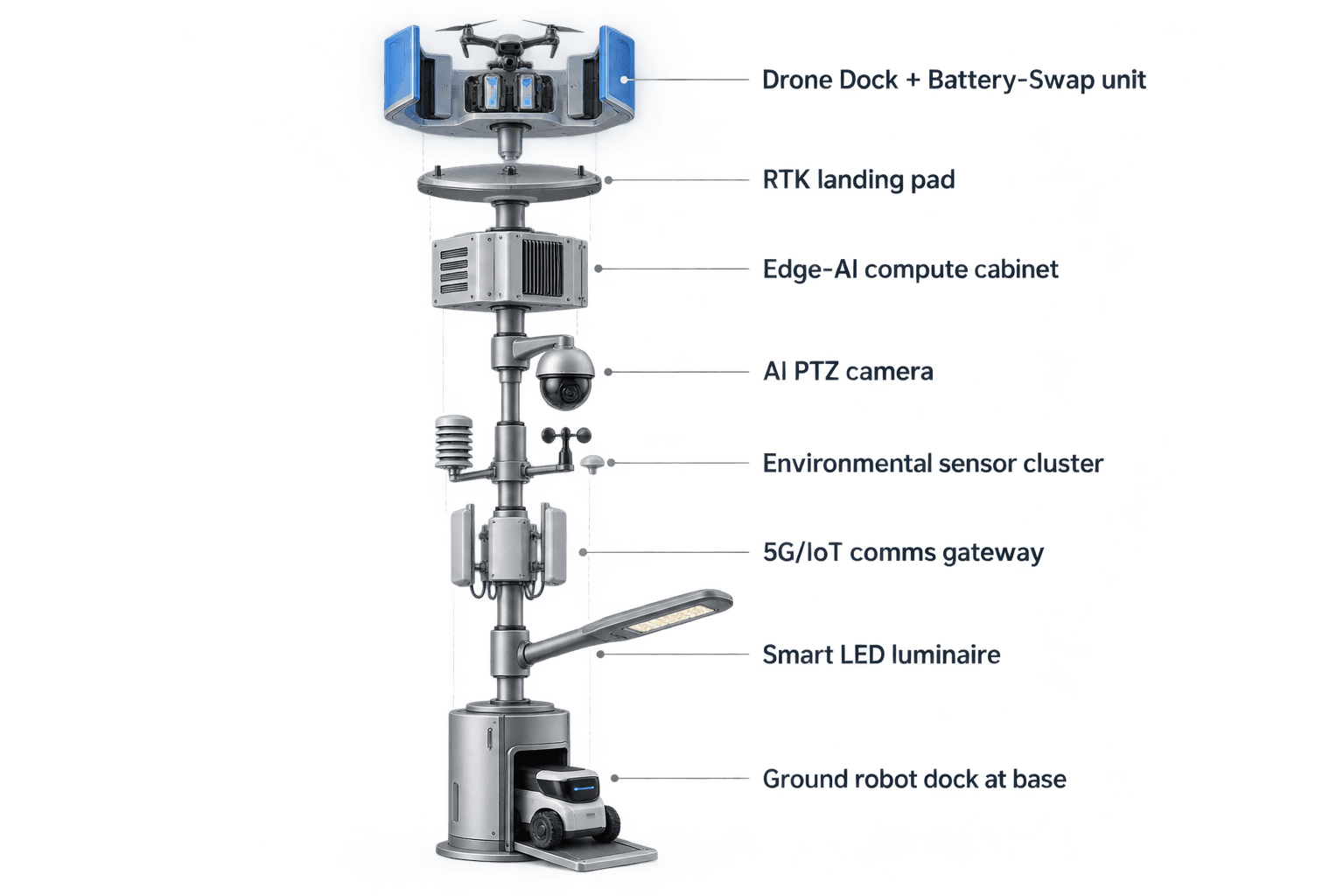
For Ho Chi Minh City’s port-border-watch task, power is the module focus because flood-season resilience depends on keeping the node alive when trenching, grid tie-ins, temporary construction power, or site utility access are unsuitable. Sky Hub is designed as a fully off-grid, battery-backed micro-station. It does not depend on grid, city or site power. Its pole body carries about 15 square meters of 360-degree wrapped flexible CIGS thin-film solar replenishment over a vertical body roughly eight meters tall and about 0.6 meters wide, with around 2.4 to 2.7 kWp nameplate.
The design should be stated honestly. A vertical cylinder does not harvest as if the whole wrap faced the sun at once. In a high-irradiance region, realistic clear-sky output is roughly 0.8 to 1.1 kW DC peak, often peaking mid-morning or mid-afternoon rather than at noon, with about 6 to 9 kWh per day. Ho Chi Minh City’s flood-season weather can reduce production further, so the solar layer should be treated as supplemental replenishment, not unlimited pure solar self-sufficiency.
Operationally, the battery system matters as much as generation. A 5 to 20 kWh-class storage design buffers drone battery swaps, edge inference, PTZ observation, communications, environmental sensing and robot charging windows. The pole’s scheduler can prioritize evidence collection and safety tasks, defer lower-priority workloads, and sequence drone or robot missions by duty cycle when solar replenishment is limited. Final energy sizing remains subject to site shading, mission frequency, local weather, mounting constraints and engineering confirmation.
Drone-Led Evidence Workflow
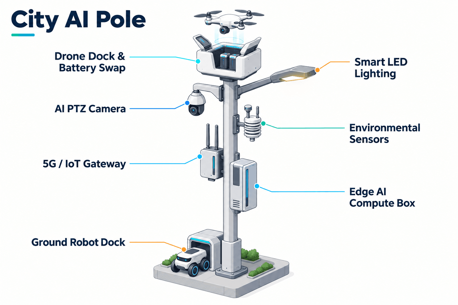
In the proposed border-watch workflow, the Sky Hub node acts as a local sensor, compute and sortie-management station. A PTZ camera supports anonymous vehicle count, crowd density estimation, intrusion awareness and perimeter event detection. Environmental monitoring adds wind speed, wind direction, temperature, humidity, atmospheric pressure, noise, PM10, PM2.5 and illuminance, helping operators decide whether a drone sortie is suitable and whether weather may affect evidence quality.
When the edge module classifies an event, raw video and sensor data stay on the pole for local processing. Only de-identified event and status metadata may leave the pole for the common operating picture. The operator sees a scored event, location context, node health, battery state, drone readiness and mission options. The drone operations management layer handles route planning, task queueing, charge or swap state, fleet health and mission logs. A landed drone can receive an automated rear-service battery exchange from a multi-bay magazine, enabling several consecutive sorties without an operator standing at the pole.
For port boundary evidence collection, the drone’s role is to verify the scene, capture incident context, inspect fence-line or waterway-side conditions, and return for swap or standby. Ground robot operations can complement the air layer by patrolling accessible surfaces, responding to alarms, inspecting assets and returning to the pole base for wireless charging. Air-ground coordination is managed through the node’s command view, with human-in-the-loop authorization for response decisions.
Governance, C-UAS And Evaluation
The command model follows the sensing to authorized assessment and response to edge-compute scheduling to field operations and maintenance loop. In practice, that means the park-operator sees one common operating picture rather than disconnected camera, drone, robot and maintenance consoles. The COP can display event status, drone readiness, storage state, environmental conditions, mission logs and maintenance alerts while keeping raw data local on the node.
For data governance, the deployment is PDPL- and LGPD-oriented by design because processing is local-first. This is not a certification claim. It means the architecture is designed to minimize outbound data by retaining raw video and sensor streams on the pole and sending only de-identified event or status metadata where required. Face recognition and licence-plate recognition are not active deployed capabilities in this case. The evidence package should focus on time, location, object category, event type, operator decision, drone task status and de-identified media-derived metadata.
Counter-UAS coordination is handled carefully. The pole can detect and track an unauthorized drone using its own sensing and, where available, optional partner-sensor inputs. Radar is not built into the pole. If a response is required, a human authorizes the node’s friendly drone to perform non-kinetic mitigation such as soft aerial net-capture or close-approach deterrence. The system is not described as a shoot-down, jamming, denial, weapon or autonomous attack platform. For the buyer, the evaluation question is whether the single-pilot node improves evidence readiness and response-time confidence under real port and flood-season operating conditions.
System Configuration
| Parameter | Configuration |
|---|---|
| Deployment mode | Single-pilot Sky Hub node for port-border-watch evaluation, subject to final engineering confirmation. |
| Power system | Fully off-grid battery-backed micro-station with 360-degree wrapped flexible CIGS thin-film replenishment and duty-cycle scheduling. |
| Edge AI compute | Jetson-class on-pole inference module, Orin- or Thor-class, scheduling local workloads and retaining raw data on the pole. |
| Camera and sensing | AI PTZ for anonymous vehicle count, crowd density, intrusion and perimeter awareness, plus nine-factor environmental monitoring. |
| Drone operations | Autonomous launch, patrol, inspection, return, mission logs, route planning, task queueing and automated multi-bay battery hot-swap. |
| Ground robot operations | Autonomous patrol, alarm response, inspection, air-ground coordination and wireless charging at the pole base. |
| C-UAS coordination | Detection and tracking with human-authorized non-kinetic friendly-drone response; optional partner-sensor inputs may support tracking. |
How It Works
- On-pole sensing flags a boundary anomaly and assigns an event category locally.
- Edge AI scores the event, keeps raw data on the pole and prepares de-identified metadata for the COP.
- A human operator reviews the event package and authorizes a drone sortie or ground response.
- The drone launches, inspects the boundary condition, captures scene context and returns to the Sky Hub.
- The node logs mission status, battery swap state, operator decision and de-identified evidence metadata.
- Field teams use the COP record to decide follow-up maintenance, security response or closure.
Planning Assumptions (Indicative)
Illustrative planning inputs a buyer can recompute — target metrics, not achieved results. Subject to final engineering confirmation.
| Metric | Planning assumption | Indicative value |
|---|---|---|
| Inspection labor | Drone patrol replaces selected manual perimeter checks during high-risk night or flood-season windows. | ~10 patrol segments per week automated for evaluation. |
| Evidence readiness | Each qualifying perimeter event creates a de-identified event package before field dispatch. | ~1 incident package per verified anomaly. |
| Response-time KPI | Measure detection-to-review, authorization-to-launch and launch-to-first-evidence as separate target intervals. | 3 target intervals tracked per event. |
| Energy duty cycle | Battery storage buffers high-power drone and robot tasks while solar replenishment supports daily recovery. | 5-20 kWh-class storage planning range. |
| Operational coverage | Single node is placed at one priority boundary point rather than used to claim broad citywide coverage. | 1 perimeter segment for pilot evaluation. |
Deployed Equipment
- SOLARTODO Sentinel Sky Hub pole-form edge node
- Battery-backed off-grid power cabinet
- 360-degree wrapped flexible CIGS thin-film solar layer
- AI PTZ camera and environmental sensor suite
- Drone launch, landing and automated battery hot-swap module
- Ground robot wireless charging interface at pole base
- On-pole edge inference and workload scheduling cabinet
- Common-operating-picture command view
Frequently Asked Questions
Is Sky Hub a smart streetlight for Ho Chi Minh City roads?
No. In this proposed case, Sky Hub is a pure smart pole with no lighting system. It is positioned as a physical-AI city edge node for port-border-watch operations, combining off-grid power, local sensing, edge compute, drone operations, ground robot support and command coordination rather than road illumination.
Does the node depend on grid, city or site power?
No. The proposed configuration is fully off-grid, using battery storage plus 360-degree wrapped flexible CIGS thin-film solar replenishment. The solar layer is a supplemental replenishment source, not an unlimited self-sufficiency claim. Mission duty cycles, storage sizing and charging schedules should be confirmed against local weather, shading and operational demand.
What makes power the main focus for this Ho Chi Minh City scenario?
Flood-season port operations can make utility access, trenching, temporary connections and manual patrol routes difficult. A battery-backed off-grid node allows the park-operator to place sensing, compute and drone readiness at a priority boundary point without relying on local site power, while scheduling high-power tasks according to available stored energy.
What evidence does the system collect for border-watch decisions?
The node is designed to produce de-identified event and status metadata for the command view, such as event type, time, location context, confidence score, mission state and operator decision. Raw video and sensor data stay on the pole for local processing. The case does not claim face recognition or licence-plate recognition as active capabilities.
How does the drone workflow support response-time evaluation?
The park-operator can measure detection-to-review, authorization-to-launch and launch-to-first-evidence as separate target intervals. The purpose is to see whether drone-led verification can produce usable scene context before a field team is dispatched, especially when flood-season access or night patrol conditions slow manual confirmation.
How is Counter-UAS handled without unsafe escalation?
The node may detect and track unauthorized drone activity and present it for human review. If response is authorized, the friendly drone can perform non-kinetic actions such as soft aerial net-capture or close-approach deterrence. The case does not describe shoot-downs, jamming, denial, weapons or autonomous attack behavior.
Is this article claiming a completed citywide deployment or measured results?
No. This is a proposed illustrative configuration for a single-pilot evaluation by a port-area park-operator in Ho Chi Minh City. KPI values are framed as planning inputs and evaluation metrics, not achieved outcomes. Final performance depends on engineering survey, placement, weather, operating rules and acceptance testing.
Explore Further
- City AI Pole / smart streetlight product line
- More smart-city deployment cases
- Talk to our engineering team
Planning a similar physical-AI deployment for streets, campuses or public spaces? Request an engineering consultation