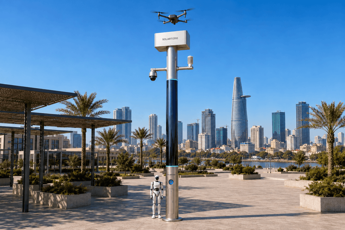
A City AI Pole is a non-lighting physical-AI edge node combining local computing, sensing, stored energy and coordinated drone and ground-robot operations. SOLARTODO Sentinel’s Sky Hub form runs OTATODO on the pole. This proposed Ho Chi Minh City industrial-park deployment supports fire-response coverage across a river cross-section using fully off-grid power, automated drone battery exchange and human-authorized operational coordination.
1. Review brief: a sports-event fire alert exposes the coverage question
The incident reviewed here is an illustrative planning scenario, not a report of an actual fire or an awarded deployment. During a proposed industrial-park sports-event operating window, an emergency-management desk receives a report of smoke near a riverfront service yard. Warehouses obscure the approach from inland roads, while the opposite bank offers a potentially useful observation angle. The immediate task is to establish which areas can be assessed safely, which remain unseen and where responders should approach.
Ho Chi Minh City provides a concrete setting for this problem. Its industrial and logistics geography includes Hiep Phuoc, which the city’s investment and trade promotion agency lists as an industrial park. That establishes local industrial context; it does not establish a SOLARTODO customer relationship. Ho Chi Minh City ITPC industrial-park listing.
The proposed configuration applies to a selected river-facing industrial-park boundary in this setting. A sports event creates a temporary planning trigger: pedestrian gathering points, service vehicles and emergency access routes need to be considered together. No particular event, organizer or attendance figure is asserted.
For the emergency-management buyer, the review asks a coverage question before a response-speed question: can the command desk distinguish an observed area from an assumed-clear area? A fixed camera may show a gate while leaving the river-facing side of a warehouse unseen. A drone may resolve that obstruction, but its return for energy replenishment can reopen the gap. The deployment therefore centers on the pole’s automated battery-swap capability and the operational coverage it can support.
2. Reconstructing the blind spot: design around a river cross-section
The proposed deployment treats a river cross-section as an operational corridor connecting the industrial bank, the water surface and an authorized observation area on the opposite bank. It is a coverage geometry, not a claim that a single camera sees through buildings or that a drone can cross every waterway without restrictions. Final pole positions, flight envelopes and observation rights remain subject to final engineering confirmation and applicable authorization.
The review begins by marking priority observation zones: the reported smoke location, adjacent warehouse faces, waterside access, emergency assembly areas and the responder approach. Surveyors then document what the pole-mounted PTZ camera can actually observe from its installed position. Occluded zones become explicit tasks rather than disappearing into a nominal camera radius. Drone observations add an elevated perspective; the ground robot checks accessible routes and perimeter conditions from below.
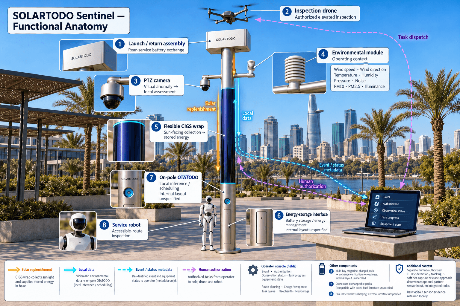
Sky Hub is the flagship pole-form deployment of SOLARTODO Sentinel: a PURE smart pole with no lighting system. Its role is to host sensing, edge computing, energy storage and air-ground operations at the location where the coverage problem occurs. It is fully off-grid, using on-pole solar replenishment and battery storage without grid, city or site power.
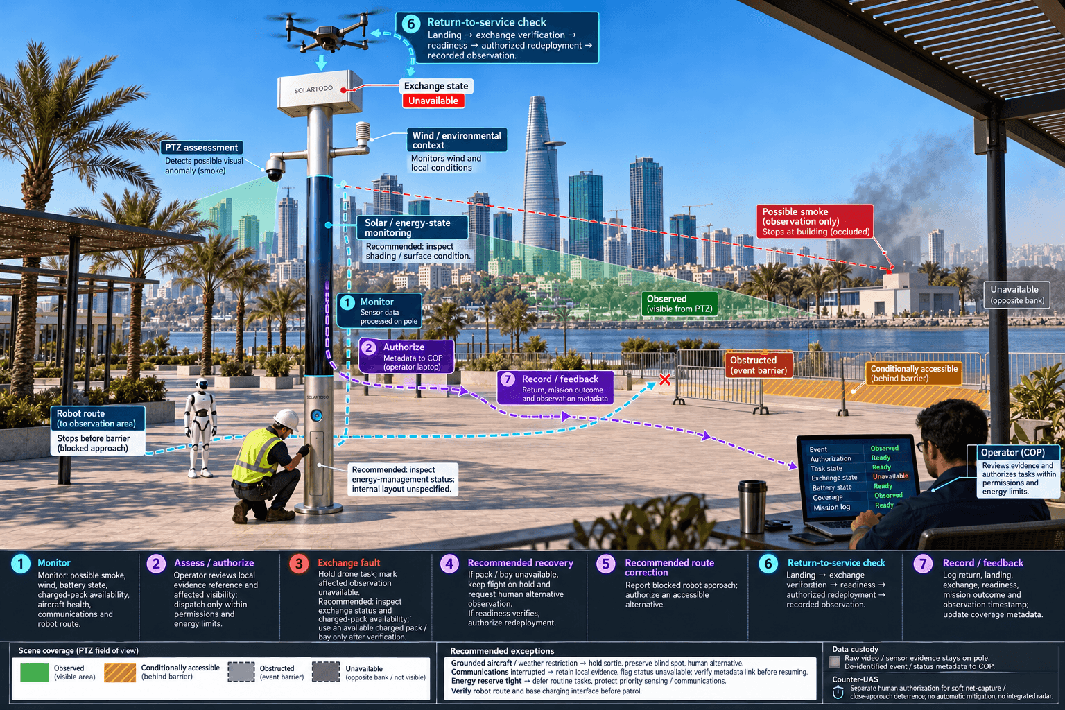
Placement must preserve safe drone launch and recovery space, robot access to the base, maintenance clearance and separation from sports-event gathering areas. Riverfront exposure, foundation conditions, flood levels, shading and access for servicing all require site assessment. The proposal does not assign a deployment quantity or coverage area before that work. The buyer’s deliverable is a map showing observed, obstructed, conditionally accessible and unavailable zones, with the reasons for each classification.
3. Response reconstruction: battery exchange sustains the observation task
In the illustrative incident sequence, the PTZ camera flags a visual anomaly for local assessment. Environmental measurements supply context, while the emergency-management operator evaluates the alert and authorizes the appropriate response. A possible smoke indication remains an assessment input; the node is not presented as a certified fire detector. The drone receives an authorized inspection route to examine the obscured warehouse face and river edge without requiring an operator at the pole.
The decisive coverage issue appears when that aircraft must return. Sky Hub’s multi-bay battery magazine performs an automated rear-service exchange: the landed drone receives a charged pack, the system verifies the exchange state and the mission queue can redeploy it. Several bays support consecutive sorties when charged packs, aircraft condition and the energy budget permit. This reduces dependence on an on-site person changing batteries, but it does not eliminate landing, exchange, checks or transit time.
Drone operations management connects route planning, the charge/swap state machine, task queueing, fleet health and mission logs. A failed exchange or unavailable charged pack must produce an explicit coverage limitation. The command view should never display a scheduled flight as completed observation. PTZ coverage and ground patrol can support the response during a turnaround, with their own visibility limits clearly shown.
A service or humanoid robot can inspect an authorized, accessible route, report an obstructed approach, support alarm response and coordinate with the airborne task. It returns to the pole base for wireless charging. It does not enter a hazardous fire environment simply because it is available. Human responders retain incident command, while the node supplies local observations and coordinated field support.
4. Command review: one operational picture with local data custody
OTATODO runs the on-pole edge-compute and scheduling layer. The proposed compute module performs local inference and allocates workloads among perception, drone operations, robot tasks and energy management. Raw video and sensor data stay on the pole and are processed locally. Only de-identified event and status metadata may leave it. The remote common-operating-picture command view therefore uses event locations, observation status, task progress and equipment state rather than exporting raw feeds.
The operations loop combines sensing, authorized assessment and response, edge-compute scheduling, and field operations and maintenance. For this incident review, the command desk should be able to trace a reported anomaly to its assessment, authorization, dispatched task and recorded outcome. It should also see whether a priority zone is currently observed, awaiting a sortie or unavailable. Anonymous vehicle counts, crowd density, intrusion and perimeter awareness help describe access conditions without claiming face or licence-plate recognition.
The nine-in-one environmental module measures wind speed, wind direction, temperature, humidity, atmospheric pressure, noise, PM10, PM2.5 and illuminance. These measurements provide operating context; particulate readings alone do not establish a fire’s location or severity. Wind observations also inform flight decisions alongside aircraft operating limits and the incident commander’s instructions.
Counter-UAS coordination remains a separate, human-authorized workflow. If an unauthorized drone is detected and tracked, an authorized person may command the node’s friendly drone to perform soft aerial net-capture or close-approach deterrence under approved conditions. Mitigation is non-lethal and non-kinetic. Radar is not built into the pole; any radar information would come from an optional partner-sensor input. Neither an intrusion alert nor an emergency automatically authorizes mitigation.
5. Energy review: protect coverage through a finite off-grid budget
The proposed cylindrical pole carries approximately 15 m² of flexible CIGS thin-film wrapped through 360° around a roughly 8 m tall, 0.6 m-wide body. Its approximate 2.4–2.7 kWp nameplate rating must be distinguished from field output. A vertical cylinder collects direct sunlight on its sun-facing projection, not across the entire wrapped area at once.
As a reference for a high-irradiance region such as Saudi Arabia, realistic clear-sky output is roughly 0.8–1.1 kW DC peak and about 6–9 kWh per day. Peak collection can occur in mid-morning or afternoon rather than at noon. These figures are not a Ho Chi Minh City yield forecast. Local shading, seasonal weather, surface conditions and installation geometry require a site-specific energy assessment.
Solar is a supplemental replenishment layer within a fully off-grid, battery-backed micro-station. Proposed storage is in the 5–20 kWh class, with final capacity determined by the agreed workload and engineering review. Storage buffers high-power drone and robot activity; it does not create unlimited energy. A charged drone-pack inventory also represents stored energy that must eventually be replenished.
The emergency-management review should therefore examine coverage alongside energy state. Before the sports-event window, scheduling reserves energy for priority sensing, communications and authorized response tasks. Routine inspections can be deferred when reserves tighten. If weather, aircraft condition or battery availability prevents a flight, the COP must identify the affected blind spot and support a human decision about alternative observation or dispatch. The acceptance question is whether finite resources are allocated transparently to the highest-priority coverage needs.
6. Review disposition: evaluate coverage before claiming improvement
The proposed acceptance framework measures verified observation of agreed priority zones during agreed operating windows. It distinguishes camera visibility from drone observation, scheduled missions from completed tasks, and temporary coverage from continuous observation. A river cross-section is considered assessed only to the extent supported by recorded observations and their timestamps; an unobserved bank remains an identified gap.
Battery-swap evaluation should record return, landing, exchange verification, readiness and redeployment as separate states. Reviewers can then determine how much of an observation gap arises from aircraft transit, exchange activity, weather restrictions or mission prioritization. Several charged packs may support repeated sorties, but that capability should not be converted into an unsupported claim of uninterrupted aerial coverage.
The accompanying calculations are hypothetical planning inputs that the buyer can replace with surveyed zones, approved observation intervals and measured task energy. They are not achieved results, local statistics or product performance guarantees. Evaluation should include normal operation, an unavailable battery bay, a grounded aircraft, interrupted communications and a robot route blocked by event infrastructure. Each condition tests whether the command view preserves an honest account of coverage.
The review disposition is a proposed industrial-park configuration, subject to final engineering confirmation, site access and operational authorization. SOLARTODO Sentinel is presented as an in-service product with mature workflows; no claim is made that this specific Ho Chi Minh City installation already exists. Its local-processing design is PDPL/LGPD-oriented, without asserting certification or Vietnamese legal compliance. Procurement should proceed from an agreed coverage map, an energy and duty-cycle budget, and evidence requirements that emergency management can independently review.
System Configuration
| Parameter | Configuration |
|---|---|
| Pole and deployment geometry | PURE non-lighting cylindrical edge-node pole; approximately 8 m tall and 0.6 m wide; proposed river-cross-section observation layout |
| Off-grid energy | Approximately 15 m² of 360°-wrapped flexible CIGS, 2.4–2.7 kWp nameplate; 5–20 kWh-class battery storage; no external power connection |
| Edge computing and data | On-pole AI compute running OTATODO; local inference and workload scheduling; raw video and sensor data retained on the pole |
| Drone operations and battery exchange | Autonomous launch, inspection, return and redeployment; multi-bay magazine with automated rear-service battery exchange and verified readiness states |
| Ground robot operations | Service or humanoid robot for authorized patrol, inspection and alarm response; return-to-base wireless charging |
| Security and environmental sensing | PTZ camera with local perception; nine environmental measurements: wind speed, wind direction, temperature, humidity, pressure, noise, PM10, PM2.5 and illuminance |
| Command coordination | Metadata-based COP with human authorization, mission logs and coverage status; human-authorized non-lethal C-UAS coordination; no integrated radar |
How It Works
- On-pole perception flags a possible smoke anomaly and records its local evidence reference.
- Local inference adds environmental context and identifies affected observation zones.
- An emergency-management operator assesses the event and authorizes the inspection task.
- OTATODO schedules the drone sortie and safe ground-robot support within energy limits.
- The returning drone undergoes verified rear-service battery exchange before authorized redeployment.
- Raw evidence remains on the pole while de-identified event, authorization and coverage-status metadata update the COP.
Planning Assumptions (Indicative)
Illustrative planning inputs a buyer can recompute — target metrics, not achieved results. Subject to final engineering confirmation.
| Metric | Planning assumption | Indicative value |
|---|---|---|
| Priority-zone coverage target | ILLUSTRATIVE ONLY: define 10 priority zones and target verified observation of 8 during an agreed review window. | 8 ÷ 10 × 100 = 80% target zone coverage; not an achieved result |
| Observation-window coverage | ILLUSTRATIVE ONLY: plan a 120-minute operating window and target 90 minutes with valid observation of a selected priority zone. | 90 ÷ 120 × 100 = 75% target observation-window coverage |
| Battery-exchange review workload | ILLUSTRATIVE ONLY: review 6 exchange records for 5 minutes each; these are documentation inputs, not exchange-duration claims. | 6 × 5 = 30 minutes of planned review effort |
| Usable storage planning | ILLUSTRATIVE ONLY: select 10 kWh nominal storage and reserve 30% from task allocation; exclude conversion losses from this simple calculation. | 10 × (1 − 0.30) = 7 kWh before conversion losses and other operating loads |
| Hypothetical sortie energy allocation | ILLUSTRATIVE ONLY: budget 4 sorties at an assumed 0.5 kWh each; replace this assumption with measured aircraft and charging data. | 4 × 0.5 = 2 kWh of hypothetical sortie energy allocation |
Deployed Equipment
- Non-lighting cylindrical Sentinel Sky Hub pole with wrapped flexible CIGS solar
- Battery storage cabinet with energy-management controls
- On-pole AI compute and local evidence storage
- PTZ camera and nine-in-one environmental sensing module
- Drone launch-and-return assembly with multi-bay rear-service battery magazine
- Inspection drone with compatible exchangeable battery packs
- Service or humanoid robot with pole-base wireless charging pad
- Communications gateway for de-identified event and status metadata
Frequently Asked Questions
Is this an existing Ho Chi Minh City customer deployment?
This case study describes a proposed configuration and an illustrative incident-review scenario. It does not identify an installed customer site, actual fire or achieved coverage result. SOLARTODO Sentinel is an in-service product, while the specific river-cross-section layout, equipment selection and operating procedures described here require site assessment and final engineering confirmation.
How does automated battery exchange improve the coverage plan?
Automated rear-service exchange allows a landed drone to receive a charged pack without an operator changing batteries at the pole. Multiple magazine bays support consecutive sorties when energy and equipment readiness permit. Coverage evaluation must still include return flight, landing, exchange verification and redeployment, because those activities can leave an observation gap.
Can the pole operate without grid or industrial-park power?
Yes. The proposed system is fully off-grid, combining on-pole CIGS solar replenishment with battery storage. It has no dependence on grid, city or site power. Solar replenishment is finite, so final storage capacity, charged-pack inventory and drone and robot duty cycles must be engineered around the agreed workload and local conditions.
Does the emergency-management command view receive live raw video?
Raw video and sensor data stay on the pole for local processing. Only de-identified event and status metadata may leave it. The remote COP therefore presents task states, event summaries and coverage information through metadata. Procurement should confirm that this operating model meets the buyer’s incident-command needs without assuming raw-feed export.
What can the system establish during a suspected industrial fire?
The system supports assessment through local camera perception, environmental context and authorized aerial or ground inspection. It can help identify observed areas, obstructed approaches and remaining blind spots. A visual anomaly or particulate reading is not by itself a verified fire diagnosis, and the proposed configuration does not replace specialist fire detection or emergency responders.
Who authorizes drone response and counter-UAS activity?
The designated emergency-management operator authorizes incident-response tasks within approved procedures. Counter-UAS mitigation requires separate human authorization and applicable authority. Allowed coordination comprises detection, tracking and commanding a friendly drone for soft aerial net-capture or close-approach deterrence under approved conditions. An alert does not itself authorize mitigation, and radar is not integrated into the pole.
What should buyers verify before accepting the configuration?
Buyers should verify surveyed visibility, flight permissions, safe operating areas, robot access, environmental limits, energy reserves and battery-exchange behavior. Acceptance records should show whether priority zones were actually observed during agreed windows. Local processing is PDPL/LGPD-oriented, but this wording does not establish certification or compliance with Vietnamese requirements; those obligations need separate assessment.
Explore Further
- City AI Pole / smart streetlight product line
- More smart-city deployment cases
- Talk to our engineering team
Planning a similar physical-AI deployment for streets, campuses or public spaces? Request an engineering consultation