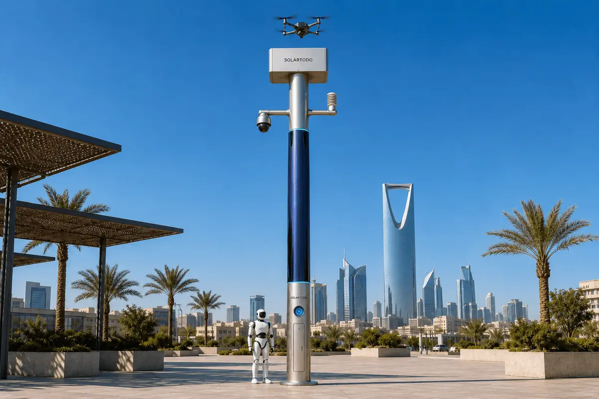
A City AI Pole is a non-lighting physical-AI edge node that combines off-grid energy, sensing, edge compute, drone operations and robot coordination in one urban pole. In this Jakarta industrial-park case, SOLARTODO Sentinel Sky Hub supports campus-perimeter fire response by detecting anomalies locally, dispatching autonomous inspection drones, coordinating field response and recording de-identified operational metadata.
Jakarta Fire-Response Context
Jakarta’s industrial districts and logistics campuses operate under a difficult emergency-management profile: dense perimeter roads, mixed warehouse and production activity, high vehicle movement, humid weather, seasonal rain and event-driven traffic surges. During major sports-event periods, emergency access can become slower because public-road congestion, contractor movement and temporary crowd flows increase outside normal industrial rhythms. For an emergency-management buyer, the operational issue is not only detecting a fire-risk condition. It is reducing the time spent sending people to manually inspect distant perimeter points before a response decision can be made.
This proposed configuration places SOLARTODO Sentinel Sky Hub units along a campus perimeter inside an industrial-park environment in Jakarta. The deployment is framed around fire response rather than general surveillance. Each pole acts as a physical-AI city edge node: it hosts sensing, compute, energy storage, a drone-nest workflow and ground-robot coordination without using city power, site power or grid connection. It is a pure smart pole with no lighting system. The role is to watch defined risk zones, classify potential anomalies on the pole, launch a drone for rapid visual confirmation, support a human-authorized response decision and keep an auditable mission record.
The priority KPI is labor replacement for repetitive patrol and verification work. Instead of measuring success through abstract “smart city” language, the buyer can evaluate how many routine night patrols, perimeter checks and alarm-verification walks can be automated or reassigned. The case remains subject to final engineering confirmation, including local wind exposure, solar access, battery sizing, radio planning, perimeter geometry, drone flight permissions and internal emergency procedures.
Campus-Perimeter Deployment Design
The deployment mode is a campus-perimeter ring, with nodes positioned near high-value or high-risk perimeter segments: warehouse edges, loading zones, fuel-handling vicinity, service gates, utility boundaries, outdoor storage lanes and blind corners that normally require manual patrol. The intent is not to cover an entire city or claim a fixed area from a single pole. The perimeter is divided into response cells, each mapped to a node, camera view plan, drone launch envelope, return path and service access point.
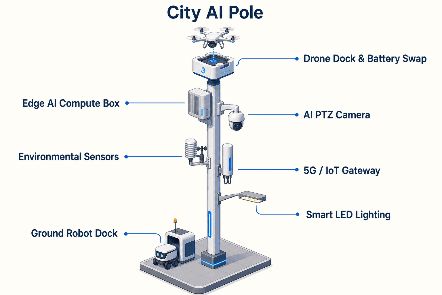
Sky Hub’s drone nest is the operational center of the configuration. A landed drone can be recovered, receive an automated rear-service battery exchange from a multi-bay magazine, and relaunch for consecutive sorties. The drone-operations manager handles route planning, task queueing, charge and swap state transitions, fleet health and mission logs. In a fire-response scenario, this matters because the first task may be confirmation, the second may be perimeter search for spread or smoke source, and a third may be post-response inspection after personnel have moved through the area.
Ground robots extend the same operating picture at lower speed and closer range. A service or humanoid robot can patrol safe campus paths, approach selected checkpoints, coordinate with aerial views and return to the pole base for wireless charging. The robot is not treated as a replacement for firefighters or trained incident commanders. It is a field operations tool for inspection, alarm response support and repeatable perimeter coverage where walking every section is slow.
The pole remains fully off-grid. Around the vertical body, approximately 15 square meters of flexible CIGS thin-film solar wrap provides replenishment over an approximately 8-meter-tall, 0.6-meter-wide cylindrical form. Because only the sun-facing projection receives direct sun at a given moment, the full wrap is not treated as a flat-panel equivalent. In high-irradiance conditions, realistic clear-sky output is roughly 0.8 to 1.1 kW DC peak and about 6 to 9 kWh per day, with peaks often mid-morning or afternoon rather than at noon. In Jakarta, local shading, haze, monsoon weather and site orientation must be confirmed; battery-backed storage and duty-cycle scheduling carry the operational load.
Operational Loop
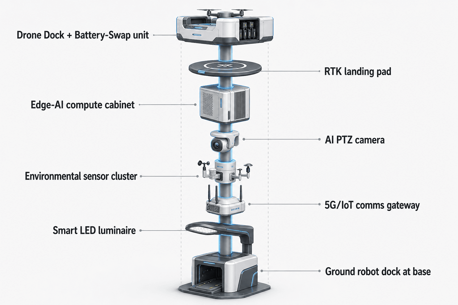
For emergency-management stakeholders, the value of the pole is the complete loop: sensing, authorized assessment and response, edge-compute scheduling, field operations and maintenance, all shown in a common-operating-picture command view. The local PTZ camera supports anonymous vehicle count, crowd density, intrusion and perimeter awareness. Environmental sensing covers wind speed, wind direction, temperature, humidity, atmospheric pressure, noise, PM10, PM2.5 and illuminance. These signals are especially relevant to early fire response because wind direction, smoke-related particulate changes, site noise and human movement patterns can affect both incident interpretation and response routing.
Edge AI compute runs local inference and workload scheduling on the pole using a Jetson-class edge module, either Orin-class or Thor-class depending on final load and thermal design. Raw video and sensor data stay on the pole and are processed locally. Only de-identified event and status metadata may leave the pole for the command view, logs or authorized integrations. This PDPL/LGPD-oriented architecture is designed around local processing and data minimization; it is not presented as a claim of completed certification.
When a fire-risk anomaly is detected, the pole does not simply generate an alert and wait for a person to walk the perimeter. It schedules the next physical action. A drone can launch for confirmation, follow a pre-approved route, stream locally processed event context, return, receive a battery hot-swap if needed and redeploy to a second task. If the event requires ground inspection, a robot can be assigned to a safe path and used for closer visual checks or coordination with staff.
Counter-UAS coordination is included as a non-lethal, human-authorized workflow for industrial campus security during event periods. The pole can detect and track an unauthorized drone and command its own friendly drone for soft aerial net-capture or close-approach deterrence after authorization. The pole does not contain built-in radar hardware; radar may only be used as an optional or partner-sensor input. The workflow excludes shoot-downs, jamming, denial actions and autonomous attack.
ROI Analysis Frame
The ROI analysis should be built as a labor-replacement and response-readiness model, not as a claimed result. The buyer starts by counting patrol obligations: scheduled perimeter walks, guard dispatches after nuisance alarms, supervisor verification trips, post-incident inspection passes and repeated checks during sports-event traffic peaks. Each of those tasks is then classified into three groups: tasks suitable for automatic drone verification, tasks suitable for robot-supported inspection and tasks that still require trained human response.
A typical planning assumption may state that drone patrol replaces a defined number of routine manual night patrols per week, while emergency staff remain responsible for authorization and incident command. Another assumption may count alarm-verification trips that can move from walking inspection to camera-plus-drone confirmation. A third may measure how many perimeter cells can be inspected during peak access disruption without sending people through congested internal roads. These are target planning inputs and should be recomputed against each campus layout.
The drone-nest module is central to this value model because fire response often requires more than one sortie. A single launch may confirm smoke, heat-risk context or a visible perimeter anomaly, but emergency-management teams may then need a second route to check nearby storage, a third to inspect the access path, and another after response crews leave. Automated battery hot-swap and task redeployment reduce idle time between sorties and avoid depending on an operator standing beside the pole.
The off-grid design also changes deployment planning. Because the node does not require city, site or grid power, the buyer can place it where the perimeter risk is highest rather than where power is already convenient. Solar wrap is treated as supplemental replenishment for a battery-backed micro-station, while high-power drone and robot tasks are buffered by 5 to 20 kWh-class storage and scheduled by duty cycle. Final engineering should confirm canopy shading, salt exposure from coastal air where relevant, rainfall patterns, service route access and aviation permissions.
Evaluation Metrics
A Jakarta emergency-management team can evaluate the proposed campus-perimeter deployment through target metrics that connect directly to operational work. The first metric is manual patrol substitution: how many scheduled patrols can be converted into autonomous patrol tasks while keeping staff available for exceptions and command decisions. The second is alarm verification effort: how many dispatches can be reviewed first through on-pole perception and a drone sortie before personnel are sent. The third is event-period resilience: how well the system maintains perimeter coverage when sports-event congestion, rain or contractor activity makes human movement slower.
The fourth metric is data discipline. Because raw video and sensor feeds remain on the pole, the buyer can evaluate how event metadata, mission logs and status records support oversight without turning the system into a centralized raw-video upload architecture. This is important for PDPL/LGPD-oriented governance and for industrial operators that want operational visibility without expanding unnecessary data movement.
The fifth metric is maintainability. Each pole should be assessed as a serviceable off-grid node: battery health, solar replenishment trend, drone bay state, robot charging state, camera availability, sensor calibration and edge-compute workload status. The common-operating-picture command view should present the emergency loop as one operational flow rather than separate dashboards. In this case study, success is defined by a buyer’s ability to replace slow manual perimeter checks with authorized, recorded, locally processed physical-AI operations, while keeping human judgment in the response chain.
System Configuration
| Parameter | Configuration |
|---|---|
| Deployment mode | Campus-perimeter Sky Hub nodes for Jakarta industrial-park fire-response cells, subject to final site engineering |
| Energy system | Fully off-grid battery-backed micro-station with approximately 15 m2 of 360-degree flexible CIGS thin-film solar wrap |
| Drone nest | Autonomous launch, return, multi-bay battery hot-swap, task queueing, route planning and mission logging |
| Edge AI compute | On-pole Jetson-class edge module for local inference, workload scheduling and de-identified event metadata output |
| Security sensing | AI PTZ camera for anonymous vehicle count, crowd density, intrusion and perimeter awareness |
| Environmental monitoring | Wind speed, wind direction, temperature, humidity, atmospheric pressure, noise, PM10, PM2.5 and illuminance |
| Robot operations | Ground service or humanoid robot patrol coordination with return-to-pole wireless charging |
How It Works
- On-pole sensing flags smoke-like haze, intrusion, abnormal movement or environmental change near a perimeter risk zone.
- Edge AI classifies and scores the event locally while raw video and sensor data remain on the pole.
- The command view presents de-identified event metadata, live status and recommended response options for human authorization.
- A drone launches from the nest to confirm the condition, inspect adjacent cells and return for automated battery hot-swap if needed.
- A ground robot is assigned to a safe campus path when closer inspection or air-ground coordination is required.
- Mission logs, swap state, operator decisions and event outcomes are recorded for review and maintenance planning.
Planning Assumptions (Indicative)
Illustrative planning inputs a buyer can recompute — target metrics, not achieved results. Subject to final engineering confirmation.
| Metric | Planning assumption | Indicative value |
|---|---|---|
| Inspection labor | Drone patrol replaces selected routine night perimeter walks while staff remain assigned to exceptions and command decisions | ~10 to 20 patrols per week automated |
| Alarm verification | On-pole perception plus drone confirmation reduces manual verification trips for low-clarity perimeter alerts | ~30 to 50 verification trips per month reviewed remotely first |
| Event-period coverage | During sports-event traffic peaks, autonomous sorties maintain checks when vehicle or foot patrol movement is slower | ~3 to 5 high-priority perimeter cells checked per response cycle |
| Drone continuity | Multi-bay battery hot-swap supports consecutive confirmation, spread-check and post-response inspection tasks | ~3 to 6 consecutive sorties planned per node before service review |
| Human authorization | Emergency-management staff authorize response escalation, C-UAS mitigation and field dispatch from the common operating picture | 100% of mitigation actions require human authorization |
Deployed Equipment
- SOLARTODO Sentinel Sky Hub pure smart pole
- 360-degree flexible CIGS thin-film solar wrap
- 5 to 20 kWh-class battery storage cabinet
- Autonomous drone nest with multi-bay battery hot-swap magazine
- AI PTZ camera for local perception
- Nine-parameter environmental sensor suite
- Jetson-class edge compute module
- Wireless robot charging base interface
Frequently Asked Questions
Is Sky Hub a smart streetlight?
No. In this Jakarta configuration, Sky Hub is a pure smart pole and does not include a lighting system. Its purpose is to host edge compute, sensing, energy storage, drone operations, robot coordination and emergency-response workflows. It should be planned as a physical-AI urban edge node, not as street lighting infrastructure.
Does the pole depend on grid, city or site power?
No. The proposed node is designed as a fully off-grid, battery-backed micro-station. The 360-degree CIGS solar wrap provides supplemental replenishment, while battery storage buffers drone, robot, sensing and compute loads. Final duty cycles should be confirmed against Jakarta shading, weather, operational tempo and service access conditions.
How does the drone nest support fire response?
The drone nest turns an alert into a physical inspection task. After local sensing identifies a possible fire-response event, an autonomous drone can launch, inspect the perimeter cell, return, receive an automated battery exchange and redeploy for follow-up checks. This supports faster verification while keeping emergency escalation under human control.
What data leaves the pole?
The architecture is designed so raw video and sensor data stay on the pole and are processed locally. Only de-identified event and status metadata may leave the node for the common-operating-picture view, mission logs or authorized integrations. This supports PDPL/LGPD-oriented data minimization without claiming completed certification.
What KPIs should an emergency-management buyer evaluate?
The strongest KPI frame is labor replacement for slow manual patrol and alarm verification. Planning teams can estimate how many scheduled perimeter walks, night checks and post-alert inspection trips can shift to drone or robot-supported workflows. These are target assumptions and should be recomputed for the actual campus perimeter.
Can the pole perform counter-UAS actions?
The pole can support non-lethal, human-authorized C-UAS coordination by detecting and tracking an unauthorized drone and commanding a friendly drone for soft aerial net-capture or close-approach deterrence. It does not use shoot-downs, jamming, denial actions or autonomous attack. Radar is not built in and may only be an optional partner-sensor input.
Explore Further
- City AI Pole / smart streetlight product line
- More smart-city deployment cases
- Talk to our engineering team
Planning a similar physical-AI deployment for streets, campuses or public spaces? Request an engineering consultation