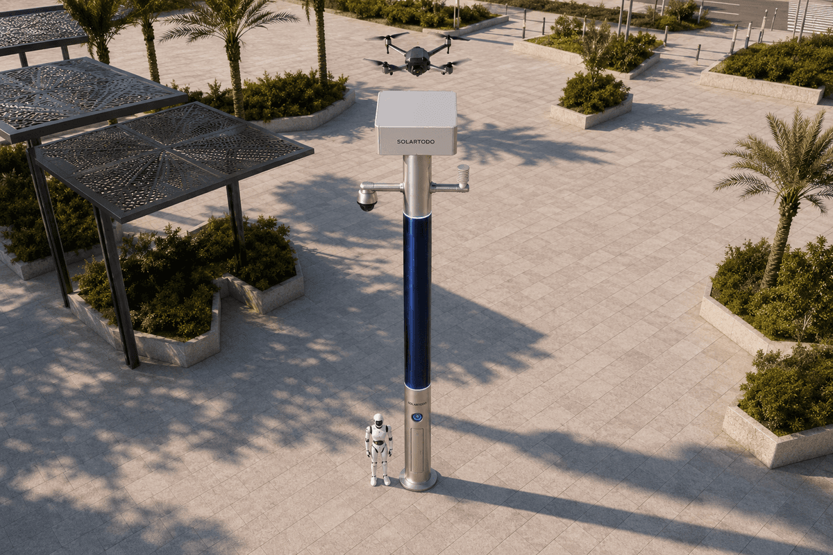
A City AI Pole is a non-lighting physical-AI edge node that hosts local compute, sensing, off-grid energy, drone operations and ground robot operations in one urban pole. In this Kuala Lumpur configuration, SOLARTODO Sentinel Sky Hub supports river cross-section inspection, environmental monitoring and utility response while keeping raw video and sensor data processed on the pole.
City Task And Holiday Trigger
Kuala Lumpur's old-town river corridors combine dense pedestrian movement, older service routes, drainage edges, utility crossings, commercial back lanes and heritage streets that become harder to inspect during holiday periods. For a power-utility stakeholder, the operational question is not whether the city needs another connected device. The question is how to maintain environmental awareness and low-altitude inspection coverage when field teams face traffic, event crowding, intermittent access and limited safe stopping points near riverbanks.
This proposed deployment uses SOLARTODO Sentinel Sky Hub as a city-ai-pole, or physical-AI urban edge node, positioned by river cross-section rather than by road lighting layout. Each node is a PURE smart pole with no lighting system. It is a fully off-grid micro-station with battery storage and 360-degree wrapped flexible CIGS thin-film solar replenishment, so it does not depend on grid, city or site power. The deployment is framed around an old-town environment task: observe river-adjacent utility conditions, support low-altitude drone inspection, coordinate ground robot checks where pavement access exists, and provide cross-department visibility through a common-operating-picture command view.
The seasonal trigger is the holiday period, when power-utility teams need broader coverage without relying on repeated manual patrols through congested areas. The core pain point is drone endurance. A drone can inspect overhead spans, pole-top equipment zones, river embankment constraints and inaccessible inspection angles, but its useful coverage is limited when every sortie must return to a remote depot or wait for manual battery handling. Sky Hub addresses that constraint by placing energy, mission scheduling, edge inference and automated battery hot-swap at the inspection node itself.
River Cross-Section Deployment Model
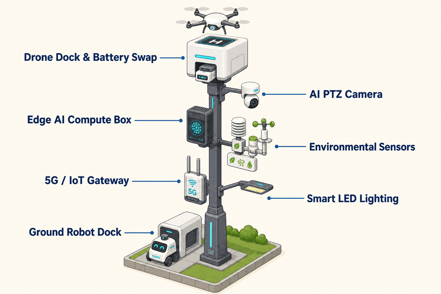
The proposed deployment mode is a river-cross-section pattern. Instead of treating the corridor as a continuous line of generic roadside assets, the utility selects recurring cross-sections: bridge approaches, utility crossings, drainage-adjacent cabinets, embankment turns, pedestrian pinch points, older service lanes and perimeter edges around critical infrastructure. A Sky Hub node is then placed where it can support aerial launch and return, local environmental sensing, on-pole perception and ground robot charging from a single off-grid base.
This pattern fits Kuala Lumpur's old-town fabric because access is often uneven. A bridge may give a good aerial view but poor parking access. A service lane may be useful for ground inspection but blocked during public events. A river edge may require frequent observation after rain, but it may not justify a continuously staffed checkpoint. The node gives the power-utility and city teams a fixed operational point that can look across the section, launch low-altitude inspection sorties, receive a returning drone for battery exchange, and coordinate a ground robot when an on-foot inspection path is available.
The cross-department structure matters. The power-utility owns the inspection requirement, but the environmental team cares about particulate, noise and weather conditions; city operations care about holiday crowd pressure and blocked access; security teams care about perimeter awareness; and maintenance teams need evidence logs that support follow-up without moving raw video off the pole. The COP command view presents the loop as sensing, authorized assessment or response, edge-compute scheduling, and field operations and maintenance. That shared view reduces the gap between departments: each team sees the same event state, while the data handling model remains local-processing oriented.
Power Module Solving Drone Endurance
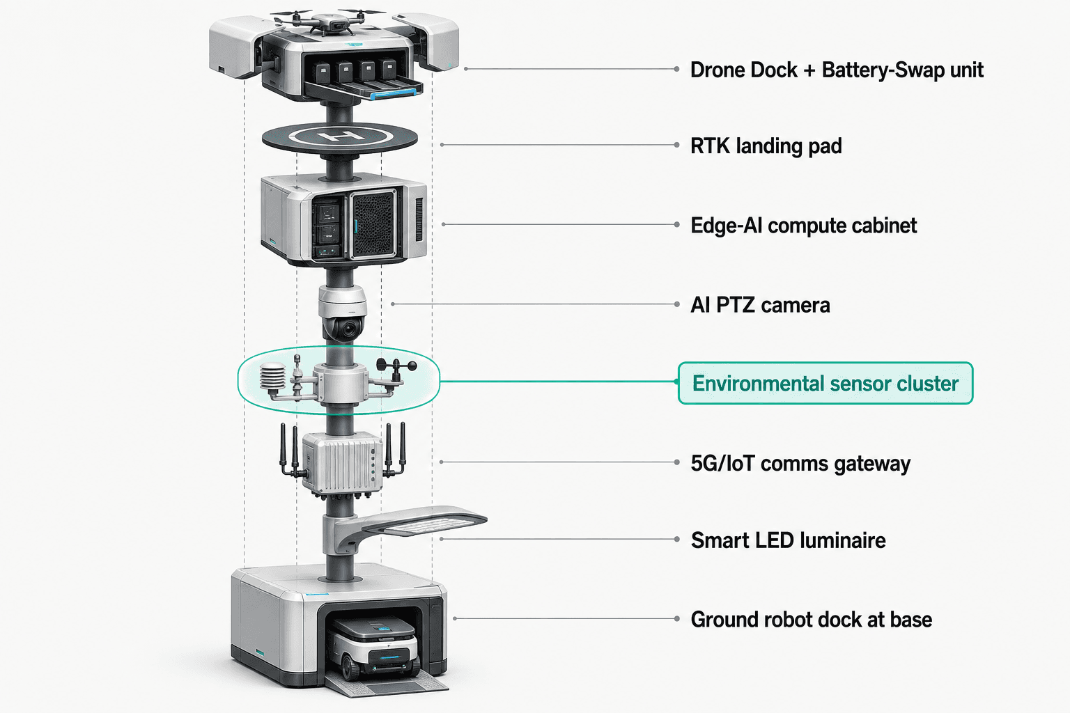
The module focus is power because endurance is the limiting factor in low-altitude inspection. Sky Hub is designed as a fully off-grid, battery-backed micro-station. The pole carries about 15 square meters of 360-degree wrapped flexible CIGS thin-film solar over a vertical body approximately 8 meters tall and 0.6 meters wide, with about 2.4 to 2.7 kWp nameplate capacity. For planning honesty, the wrap is not treated as if every square meter receives direct sun at once. A vertical cylinder mainly collects direct sun on the sun-facing projection, so realistic clear-sky output in a high-irradiance region is roughly 0.8 to 1.1 kW DC peak, usually peaking mid-morning or afternoon rather than exactly at noon, with about 6 to 9 kWh per day. Kuala Lumpur's actual duty cycle must be engineered against local shading, cloud cover, rain, air quality, mounting orientation and obstruction.
The solar layer is therefore a replenishment layer, not a claim of unlimited pure-solar self-sufficiency. High-power drone and robot tasks are buffered by 5 to 20 kWh-class storage and scheduled by duty cycle. The planning objective is coverage: how many cross-sections can remain inspectable during a holiday period with fewer depot returns, fewer manual battery interventions and fewer gaps between sorties.
A multi-bay battery magazine performs automated rear-service battery exchange for a landed drone. The drone returns to the node, receives a charged pack and relaunches for the next authorized task. Multiple bays enable several consecutive sorties, subject to final engineering confirmation of drone payload, weather, inspection route length, state of charge, solar replenishment, storage reserve and safety rules. OTATODO schedules the charge and swap state machine, task queue, mission logs, fleet health checks and edge workloads so the pole does not over-allocate stored energy during periods of weak replenishment.
Operations Across Departments
In the proposed operating model, Sentinel Sky Hub supports three connected workflows: environmental monitoring, low-altitude inspection and utility response. The environmental monitoring set covers wind speed, wind direction, temperature, humidity, atmospheric pressure, noise, PM10, PM2.5 and illuminance. These readings help operations teams understand whether a river cross-section is suitable for a drone sortie, whether a crowd or weather condition is developing, and whether maintenance timing should be adjusted.
The security sensing layer uses an AI PTZ camera with local perception for anonymous vehicle count, crowd density, intrusion and perimeter awareness. It does not claim face recognition or licence-plate recognition as an active deployed capability. Raw video and sensor data stay on the pole and are processed locally. Only de-identified event and status metadata may leave the pole for the COP view, dispatch records and maintenance workflow.
Drone operations cover launch, regional patrol, inspection, return and task redeployment without an operator on site. Ground robot operations extend the field loop at street level: a humanoid or service robot can perform autonomous patrol, alarm response, visual inspection, air-ground coordination and return to the pole base for wireless charging. Where a river edge is too congested for immediate human access, the aerial node can inspect from above while the ground robot verifies accessible points from below.
Counter-UAS coordination is handled as a non-lethal, human-authorized workflow. The pole can detect and track an unauthorized drone using its sensing stack and optional partner-sensor inputs where installed. Radar is not built into the pole. When authorized by a human operator, the node can command its friendly drone to perform soft aerial net-capture or close-approach deterrence. The system is not framed as a shoot-down, jamming, denial or autonomous attack capability.
Coverage KPI And Evaluation
The buyer KPI is coverage, expressed as target planning coverage rather than claimed achieved results. For a Kuala Lumpur power-utility evaluation, coverage can be measured as scheduled cross-section inspections completed, percentage of priority holiday windows with available node energy reserve, number of inspection angles captured without manual access, environmental alerts triaged locally, and event records closed with de-identified metadata. These measures are intentionally practical because they help a utility recompute the plan using its own route priorities, staffing model, holiday calendar and site rules.
The proposed configuration should be treated as subject to final engineering confirmation. Final placement depends on riverbank geometry, sky view, flood level constraints, foundation design, communications, permitted drone flight envelope, public safety rules, robot path availability and utility maintenance procedures. The role of Sentinel Sky Hub is to make the inspection node self-contained: power, storage, local compute, sensing, drone operations, robot charging and event logging are brought to the field edge.
For departments, the main change is operational. The environmental team receives localized condition metadata; the power-utility gets low-altitude inspection coverage with less dependence on manual battery handling; security teams gain perimeter awareness without moving raw video off-pole; and maintenance teams get traceable event records for work order review. The deployment remains a city task, not a product datasheet: improve old-town river cross-section coverage during holiday pressure while respecting local-processing, PDPL-LGPD-oriented data handling.
System Configuration
| Parameter | Configuration |
|---|---|
| Pole form | SOLARTODO Sentinel Sky Hub PURE smart pole, non-lighting, fully off-grid physical-AI edge node |
| Energy system | 5 to 20 kWh-class battery storage with 360-degree wrapped flexible CIGS thin-film solar replenishment |
| Solar surface | About 15 m2 flexible CIGS over an approximately 8 m tall, 0.6 m-wide cylindrical body; about 2.4 to 2.7 kWp nameplate |
| Edge AI compute | Jetson-class on-pole inference and workload scheduling cabinet running OTATODO |
| Drone operations | Autonomous launch, patrol, inspection, return, task queueing and multi-bay automated battery hot-swap |
| Ground robot interface | Base-side wireless charging and mission coordination for humanoid or service robot patrol and inspection |
| Sensing package | AI PTZ with local perception plus wind speed, wind direction, temperature, humidity, atmospheric pressure, noise, PM10, PM2.5 and illuminance |
How It Works
- On-pole sensing flags an environmental, access or perimeter anomaly at a selected river cross-section.
- Edge AI classifies the condition locally and scores whether low-altitude inspection is appropriate.
- A human operator reviews the COP event and authorizes drone, ground robot or maintenance response.
- OTATODO schedules compute, battery reserve, drone sortie, hot-swap state and robot charging availability.
- The drone or ground robot performs the field check and returns to the Sky Hub node for recharge or battery exchange.
- The pole records mission status, de-identified event metadata and maintenance notes for cross-department review.
Planning Assumptions (Indicative)
Illustrative planning inputs a buyer can recompute — target metrics, not achieved results. Subject to final engineering confirmation.
| Metric | Planning assumption | Indicative value |
|---|---|---|
| Inspection coverage | Priority river cross-sections are scheduled for recurring low-altitude inspection during holiday operating windows | Target: 10 to 20 cross-section checks per node per operating day |
| Manual access reduction | Drone and ground robot checks reduce the need for repeated human entry into congested old-town river-edge access points | Target: 30 to 50 percent fewer routine access visits for selected checkpoints |
| Drone redeployment | Automated battery hot-swap allows the node to support consecutive sorties without on-site operator handling | Target: 3 to 6 consecutive short inspection sorties per charged magazine cycle |
| Environmental awareness | Nine-parameter monitoring gives city and utility teams shared local condition metadata for inspection planning | Target: 15-minute condition snapshots during active holiday windows |
| Event handling | On-pole inference filters raw streams locally and sends only de-identified status events to the COP view | Target: 100 percent of routine event records created without raw video leaving the pole |
Deployed Equipment
- SOLARTODO Sentinel Sky Hub non-lighting smart pole body
- Flexible CIGS thin-film solar wrap
- 5 to 20 kWh-class battery storage pack
- On-pole edge AI compute cabinet running OTATODO
- AI PTZ camera with local perception
- Nine-parameter environmental sensor suite
- Autonomous drone bay with multi-bay battery hot-swap magazine
- Ground robot wireless charging base interface
Frequently Asked Questions
Is Sky Hub a smart streetlight for Kuala Lumpur streets?
No. Sky Hub is a PURE smart pole and includes no lighting system. In this proposed Kuala Lumpur river-cross-section deployment, the pole is used as a physical-AI edge node for sensing, compute, energy, drone operations and ground robot coordination. It should not be specified, procured or evaluated as a street lighting asset.
How does the system address drone endurance for old-town river inspection?
The endurance problem is handled at the node rather than at a remote depot. A landed drone can receive an automated rear-service battery exchange from a multi-bay magazine, while OTATODO manages task queueing, charge state, swap logic and energy reserve. This supports consecutive authorized sorties, subject to engineering confirmation of route length, payload and weather.
Does the pole require city, grid or site power?
No. The proposed Sky Hub configuration is fully off-grid, using battery storage plus on-pole flexible CIGS thin-film solar replenishment. The solar wrap is a supplemental replenishment layer, not an unlimited energy claim. High-power drone and robot tasks are buffered by storage and scheduled by duty cycle.
What data leaves the pole?
The data model is designed for local processing and PDPL-LGPD-oriented operation. Raw video and sensor data stay on the pole and are processed locally by the edge compute module. Only de-identified event and status metadata should leave the node for the common-operating-picture view, logs and maintenance workflow.
Does the sensing stack include face or licence-plate recognition?
No active deployed capability is claimed for face recognition or licence-plate recognition. The AI PTZ sensing layer is described for anonymous vehicle count, crowd density, intrusion and perimeter awareness. This keeps the deployment focused on utility inspection, environmental awareness and operational response rather than identity-based surveillance.
How is Counter-UAS handled in this configuration?
Counter-UAS coordination is non-lethal and human-authorized. The pole can detect and track an unauthorized drone using its sensing stack and optional partner-sensor inputs, then a human operator may authorize a friendly drone response such as soft aerial net-capture or close-approach deterrence. Radar is not built into the pole.
Explore Further
- City AI Pole / smart streetlight product line
- More smart-city deployment cases
- Talk to our engineering team
Planning a similar physical-AI deployment for streets, campuses or public spaces? Request an engineering consultation