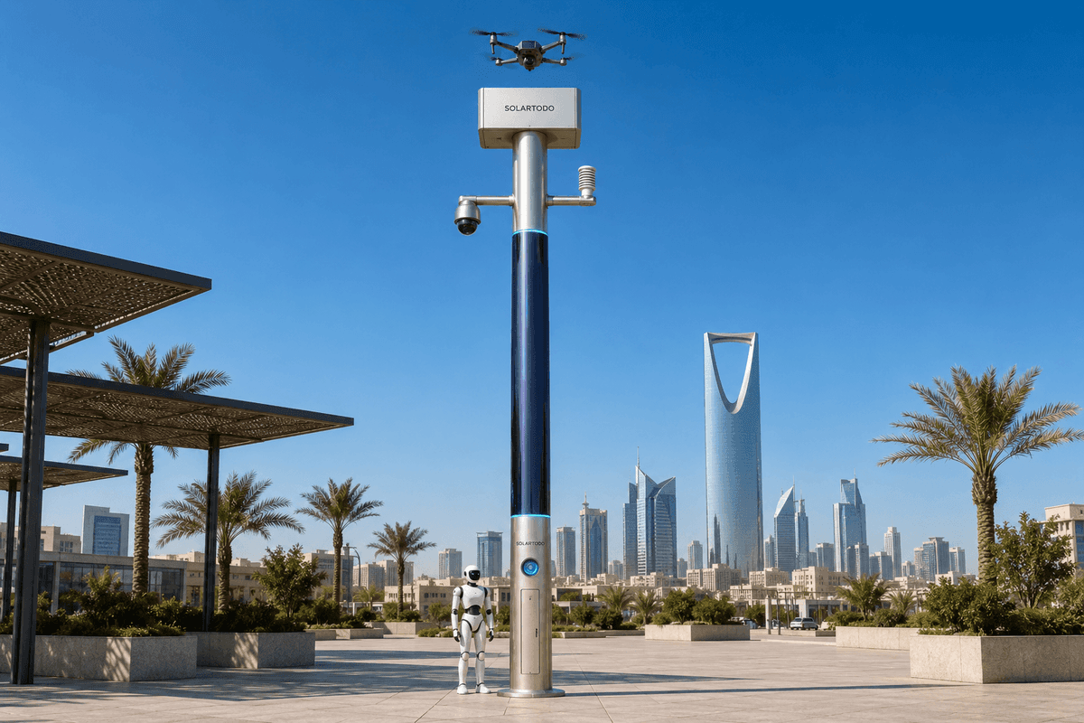
A City AI Pole is a non-lighting physical-AI edge node that combines local sensing, edge compute, off-grid energy storage, drone operations and ground robot coordination in one urban pole. This proposed Lisbon SOLARTODO Sentinel Sky Hub configuration supports flood-control monitoring by processing weather, video and mission data on the pole and sharing only de-identified event metadata.
Procurement Context: Lisbon As A River-Network City
Lisbon’s emergency-management challenge is not only rainfall; it is coordination across a river-network city where waterfront mobility, hillside runoff, underpasses, transit approaches, hospitality zones and public-event routes can all be affected during the same storm cycle. The proposed SOLARTODO Sentinel Sky Hub configuration is framed for post-disaster infill: placing physical-AI edge-node poles at selected operational gaps after flood damage, drainage overload or repeated night-time disruption has exposed where fixed awareness is thin. This is not a nation-scale rollout claim and not a completed-results narrative. It is an illustrative procurement case, subject to final engineering confirmation, for how Lisbon could evaluate edge-node poles around riverfront access, low-lying road segments, tourism corridors, campus-style public assets, port-adjacent approaches and critical-infrastructure perimeters.
The buyer persona is the emergency-management stakeholder who must coordinate municipal civil protection, drainage crews, mobility teams, public safety, environmental monitoring and field maintenance. The primary pain point is cross-department siloing: one team may see water accumulation, another owns traffic diversion, another controls field crews, another receives public reports, and another manages drone or robot response. During the night-economy season, when late operating hours, events, visitors and riverside movement create a higher duty cycle for public-space oversight, that fragmentation can make a small flood-control signal harder to turn into a timely, authorized field action.
Sky Hub is positioned here as city-ai-pole infrastructure, not as a light fixture or streetscape accessory. It is a pure smart pole with no lighting system. Its procurement relevance is that it packages sensing, compute, energy, drone operations and ground robot operations into a fully off-grid node that can be placed where conventional power restoration, cabinet access or department-owned infrastructure would slow infill.
Proposed Configuration For Flood-Control Infill
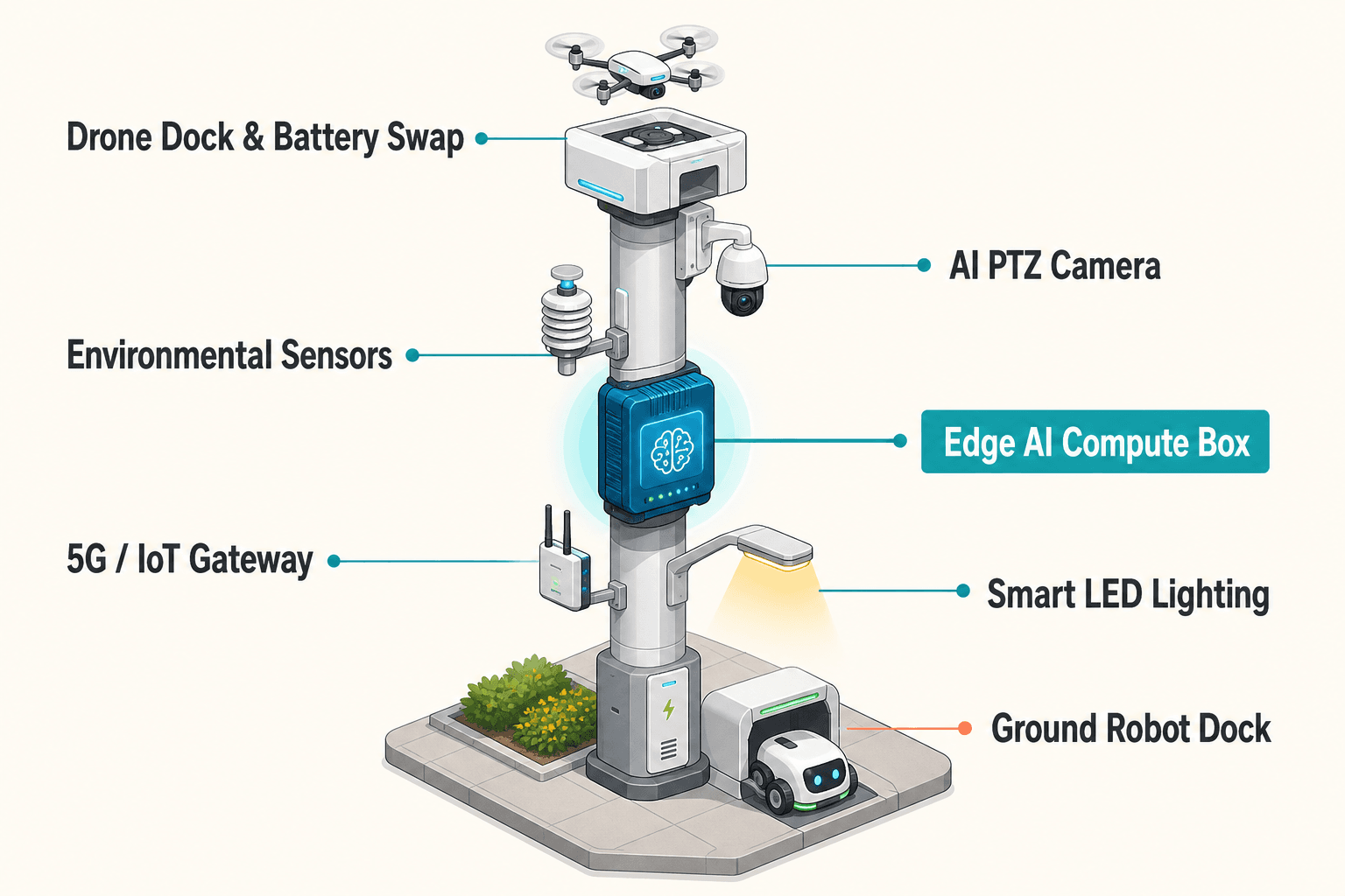
The Lisbon configuration centers on weather-sensor-driven edge computing. Each Sky Hub node would combine wind speed, wind direction, temperature, humidity, atmospheric pressure, noise, PM10, PM2.5 and illuminance sensing with an AI PTZ camera used for anonymous vehicle count, crowd density, intrusion and perimeter awareness. For a flood-control use case, the weather package is not a decorative environmental add-on; it is the trigger layer that helps determine when a riverfront or drainage-sensitive location should move from routine observation to operational assessment.
On-pole edge AI correlates the local weather stream with visual context and node health. Raw video and raw sensor records stay on the pole for local processing. Only de-identified event and status metadata may leave the pole for the common-operating-picture command view. That distinction matters for Lisbon procurement because emergency-management teams need cross-department awareness without turning every node into a continuous raw-data export point. The architecture is PDPL/LGPD-oriented by design, but this case does not claim certification or final compliance approval.
The Sky Hub form also adds field mobility. An autonomous drone can launch, patrol a nearby route, inspect a drainage bottleneck or waterfront access point, return, receive an automated rear-service battery exchange from a multi-bay magazine, and relaunch for another authorized sortie. A ground service robot can patrol a pedestrian route, inspect a closed access point, support alarm response and return to the pole base for wireless charging. These operations are scheduled by OTATODO at the edge so the pole can balance compute load, mission priority and stored energy.
Energy is handled as a fully off-grid micro-station. The pole carries about 15 m² of 360° wrapped flexible CIGS thin-film over a vertical cylindrical body, about 8 m tall and about 0.6 m wide, with roughly 2.4-2.7 kWp nameplate. Because a vertical cylinder collects direct sun mainly on the sun-facing projection rather than the whole wrap, realistic clear-sky output in a high-irradiance region is roughly 0.8-1.1 kW DC peak, typically peaking mid-morning or mid-afternoon, and about 6-9 kWh per day. The solar layer is supplemental replenishment for a battery-backed node, not an unlimited self-sufficiency claim; higher-power drone and robot tasks are buffered by 5-20 kWh-class storage and scheduled by duty cycle.
Common Operating Picture Across Siloed Teams
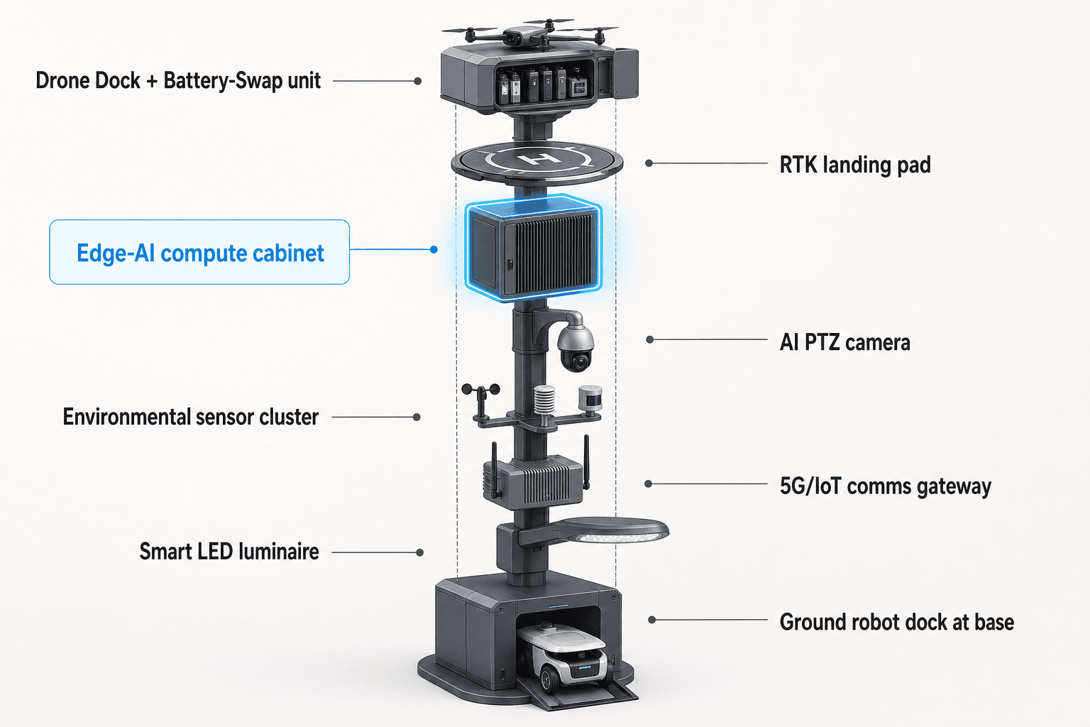
The practical procurement value is the operations loop: sensing, authorized assessment and response, edge-compute scheduling, field operations and maintenance. Lisbon emergency-management teams would see the node as part of a shared common-operating-picture view rather than as a single-department device. The weather sensor suite may flag pressure shifts, wind conditions, humidity changes and rainfall-adjacent operating context; the PTZ camera adds local anonymous scene understanding; OTATODO schedules inference and mission tasks on-pole; drone or robot response is assigned only within approved rules.
For flood-control, this means one event can carry enough context for several departments at once. A drainage team sees the field condition and the follow-up task. A mobility operator sees whether vehicle count or pedestrian density near an affected segment suggests diversion support. Public safety sees whether intrusion or perimeter awareness is relevant around a closed route. Maintenance sees whether a field visit is needed or whether a drone/robot inspection can clarify the situation first. The emergency-management desk receives a concise, de-identified event record instead of needing to reconcile separate calls, dashboards and patrol notes.
Counter-UAS coordination is included only within its permitted boundary. If the pole detects and tracks an unauthorized drone near a flood-response or critical-infrastructure zone, the node can command its own friendly drone to perform a soft aerial net-capture or close-approach deterrence after human authorization. It is non-kinetic and human-authorized only. The case does not include shoot-downs, jamming, denial effects, autonomous attack or weapons. Radar is not built into the pole; any radar mention in an engineering phase would be limited to optional or partner-sensor input.
This operating model is especially relevant for post-disaster infill because the city may not want to wait for permanent reconstruction before regaining situational awareness. A fully off-grid node can be positioned for temporary or semi-permanent operational continuity, with final siting, foundations, wind loading, communications, aviation permissions and data-governance settings confirmed during engineering review.
Opex Evaluation Without Claimed Results
This procurement case treats opex as operating effort, not as a financial promise. The evaluation should compare how many manual checks, night patrols, repeat site visits, interdepartmental handoffs and duplicate reports are needed before and after the proposed operating model is introduced. The article makes no claim that Lisbon has already achieved those outcomes, and it avoids real customer names, deployment quantities, coverage areas, detection rates and latency figures.
The strongest planning logic is substitution and triage. Drone patrols can replace selected manual night inspections where aviation rules, weather and local operating policies allow. Ground robots can support recurring route checks or perimeter confirmation without requiring every alarm to start as a vehicle dispatch. Edge inference can reduce the volume of raw material that operators need to review because the pole converts local sensing into event metadata and mission logs. Weather-sensor focus also helps prioritize the right trigger: a crowd-density alert in a nightlife corridor has a different response path when paired with wind, humidity, pressure and visibility context during a flood-control watch.
For an emergency-management buyer, the decision is not whether one pole solves flooding. The decision is whether a set of off-grid physical-AI edge nodes can reduce coordination friction at the moments when siloed systems are least useful: late-night storms, disrupted access, degraded communications, overloaded field teams and public-space reopening decisions. A well-scoped Lisbon procurement would therefore specify target evaluation metrics, authority gates, data-retention rules, mission envelopes, maintenance roles and acceptance tests before confirming final locations.
Subject To Final Engineering Confirmation
A Lisbon deployment plan should complete site engineering before procurement finalization. Required checks include foundation design, wind exposure near open waterfronts, CIGS solar yield assumptions for local shading and orientation, battery sizing against night-economy duty cycles, wireless backhaul availability, local aviation constraints for autonomous sorties, robot route suitability, weather-sensor calibration, corrosion exposure and integration with the city’s emergency-management command process.
The Sky Hub node should be procured as mature in-service SOLARTODO Sentinel infrastructure, while the Lisbon case remains a proposed configuration. That distinction keeps the case credible: the system capability set is available, but the city-specific deployment design, permissions, data-governance pack and acceptance tests must be confirmed for the chosen sites. The recommended procurement structure is therefore a configuration package with clear evaluation inputs: weather-trigger quality, authorized response workflow, mission scheduling, local data processing, field maintenance cadence and cross-department event handoff quality.
In this framing, the physical pole is not the story by itself. The city task is the story: after flood disruption, emergency management needs off-grid edge nodes that can sense local weather conditions, compute locally, coordinate drone and robot inspection, preserve data sovereignty and present a single operational view across departments. SOLARTODO Sentinel Sky Hub is the pole-form deployment shape that brings those functions to the field without requiring grid, city or site power.
System Configuration
| Parameter | Configuration |
|---|---|
| Deployment category | city-ai-pole / physical-AI urban edge node for post-disaster flood-control infill |
| Pole form | SOLARTODO Sentinel Sky Hub pure non-lighting smart pole with no lighting system |
| Energy system | fully off-grid battery-backed micro-station with 360° wrapped flexible CIGS thin-film replenishment |
| Weather sensing | wind speed, wind direction, temperature, humidity, atmospheric pressure, noise, PM10, PM2.5 and illuminance |
| Edge AI compute | Jetson-class on-pole inference and workload scheduling; raw video and sensor records processed locally |
| Drone and robot operations | autonomous drone launch, patrol, return and rear-service battery hot-swap; service robot patrol and wireless charging at pole base |
| Command view | common-operating-picture interface for sensing, authorized response, edge scheduling, field operations and maintenance records |
How It Works
- Weather sensors flag local flood-control risk context at the pole.
- Edge AI correlates weather, anonymous scene awareness and node health locally.
- The COP presents a scored event packet to authorized emergency-management staff.
- A human operator approves drone inspection, robot patrol or field-crew escalation.
- OTATODO schedules compute, energy and mission tasks on the pole.
- De-identified metadata, mission logs and maintenance status are recorded for cross-department review.
Planning Assumptions (Indicative)
Illustrative planning inputs a buyer can recompute — target metrics, not achieved results. Subject to final engineering confirmation.
| Metric | Planning assumption | Indicative value |
|---|---|---|
| Inspection labor | drone sorties replace selected manual night flood-watch patrols where rules and weather permit | ~10-20 patrol checks per week targeted for automation |
| Cross-department handoffs | one edge-generated event package is shared across emergency, drainage, mobility and maintenance teams | ~3-5 departments aligned per material event |
| Repeat field visits | drone or robot inspection clarifies whether a crew visit is needed before dispatch | ~20-30 percent fewer repeat checks targeted for evaluation |
| Operator review load | raw records stay local while de-identified event metadata and mission logs are reviewed in the COP | ~1 event packet per flagged condition instead of parallel manual reports |
| Night-economy readiness | duty-cycle scheduling prioritizes waterfront, transit and public-space checks during late operating windows | ~2-4 priority windows configured per night |
Deployed Equipment
- SOLARTODO Sentinel Sky Hub pole body
- 360° wrapped flexible CIGS thin-film solar skin
- 5-20 kWh-class battery storage cabinet
- Nine-parameter weather sensor suite
- AI PTZ camera for anonymous scene awareness
- Autonomous drone operations bay with multi-bay battery magazine
- Ground service robot wireless charging base
- OTATODO edge OS common-operating-picture interface
Frequently Asked Questions
Is the Lisbon case describing an installed municipal project?
No. This is a proposed and illustrative procurement configuration for Lisbon emergency-management planning. It does not claim a named customer, installed quantity, coverage area, measured field result or public contract. The intent is to show how SOLARTODO Sentinel Sky Hub could be evaluated for post-disaster flood-control infill, subject to final engineering confirmation.
Why is the weather-sensor module the focus for flood control?
Flood-control decisions need local context, not only camera views. Wind speed, wind direction, temperature, humidity, pressure, noise, particulate readings and illuminance help the edge node distinguish routine night-economy activity from storm-sensitive operating conditions. The weather stream becomes a trigger layer for inspection, triage and maintenance scheduling across departments.
Does Sky Hub send raw video or raw sensor records to a central platform?
No. The proposed data architecture keeps raw video and raw sensor records on the pole for local processing. Only de-identified event and status metadata may leave the pole for the common-operating-picture view. The design is PDPL/LGPD-oriented, but final legal, operational and retention settings must be confirmed by the buyer.
How does the off-grid energy model work without overstating solar output?
The pole uses battery storage as the operational buffer and CIGS thin-film as supplemental replenishment. The wrapped vertical solar surface has a nameplate rating, but field output depends on sun-facing projection, weather, shading and duty cycle. Drone, robot and compute workloads are therefore scheduled against stored energy rather than presented as unlimited solar-only operation.
What role do drones and robots play during a Lisbon flood-control watch?
The drone can inspect a drainage-sensitive segment, waterfront access point or perimeter route, then return for automated rear-service battery exchange before another authorized sortie. The ground robot can patrol accessible paths, check closures or support alarm response, then return for wireless charging. Both are coordinated by OTATODO rather than treated as separate field tools.
How is Counter-UAS handled in this procurement case?
Counter-UAS is limited to detection, tracking and human-authorized coordination. If an unauthorized drone threatens a response zone, the node can command its own friendly drone for soft aerial net-capture or close-approach deterrence after authorization. The case excludes jamming, shoot-downs, weapons, autonomous attack and any hard-kill action.
Explore Further
- City AI Pole / smart streetlight product line
- More smart-city deployment cases
- Talk to our engineering team
Planning a similar physical-AI deployment for streets, campuses or public spaces? Request an engineering consultation