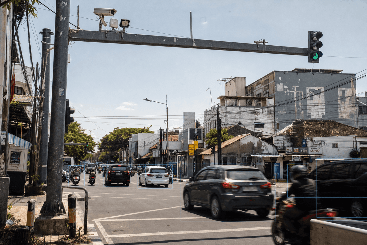
Surabaya Flood-Prone Coastal Corridors: Smart Traffic System Configuration for 14 Intersections
Summary
Surabaya’s 333 km² coastal road network, 2.87M residents, and wet-season rainfall above 300 mm/month make 14 intersections a practical BOT pilot for SOLARTODO Smart Traffic System.
Key Takeaways
A 14-intersection Surabaya configuration should prioritize sealed 8 m L-arm poles, 5G/fiber backhaul, and adaptive signal control for dense coastal arterials.
- A typical 14-intersection deployment would use approximately 56-168 poles, based on 4-12 poles per intersection.
- The recommended base unit is an 8 m dark grey hot-dip galvanized L-arm steel pole for urban signalized junctions.
- Each pole integrates 4 always-on modules: 4K AI camera, 77 GHz mmWave radar, LED fill light, and LED signal head.
- The edge layer uses NVIDIA Jetson with 98% AI camera accuracy, 45+ detection types, and under 50 ms response.
- Indonesia’s road ITS governance is anchored by Ministry of Transport PM 76/2021 for intelligent traffic management systems.
- Surabaya’s climate ranges roughly 22.5-33.4°C, with WMO/BMKG monthly rainfall peaking at 327 mm in January.
- BOT financing can reduce municipal upfront CAPEX to 0 while preserving EPC-grade commissioning and performance acceptance.
Market Context for Surabaya
Surabaya’s Smart Traffic System need is shaped by 333 km² of low-lying port-city roads, 31 districts, and recurrent wet-season drainage pressure.
Surabaya is Indonesia’s second major urban economy and East Java’s provincial capital, with 31 kecamatan and 153 kelurahan listed by the city government. The city government portal reports a population of about 2.87 million and an area of 333 km², creating a dense signal-network environment where arterial queues can propagate quickly across adjacent junctions. According to BPS Kota Surabaya (2024), the annual city statistics publication covers demographic, economic, and infrastructure indicators for municipal planning. For traffic systems, this means the buyer is usually a public agency ecosystem involving Dishub Surabaya, DSDABM, procurement units, and sometimes telecom or fiber operators.
Surabaya is also a coastal and port-linked city, so street furniture near Tanjung Perak, Kenjeran, old-town corridors, and east-west coastal approaches faces humid air, salt exposure, corrosion risk, and heavy freight movement. According to WMO/BMKG (2026), Surabaya’s climatology shows daily mean maximum temperatures from about 30.1°C to 33.4°C and January rainfall around 327 mm. The dry season is not dust-free either: high heat, braking dust, and port-truck particulates make camera windows and radar radomes maintenance-sensitive. This is why the recommended pole form should be hot-dip galvanized steel with sealed module housings and serviceable optical surfaces.
Drainage is not a side issue for traffic control in Surabaya. According to Pemerintah Kota Surabaya (2026), the city has been integrating channels and water elevations around Ahmad Yani, Gayungsari, Prapen, Tenggilis Mejoyo, and related pump-house areas. Another city update in June 2026 noted temporary ponding after intense rain and references operational response using 21 fire-service vehicles plus around 10 additional city vehicles for pumping support. These facts matter because cabinets, pole bases, fiber pits, and low-mounted power connections should be specified for water exposure rather than treated as generic urban hardware.
Surabaya already has ITS context rather than starting from zero. According to ITS Surabaya researchers (2018), the city had built ATCS-ITS using camera and sensor inputs processed in a control room for traffic lights and variable message signs. According to ANTARA Jawa Timur (2020), Dishub Surabaya uses SITS cameras at many protocol-road intersections to identify congestion points, accidents, and public-security events. ITU states, “ITS and smart mobility pave the way forward” through AI, IoT, and connectivity; in Surabaya, that direction favors edge analytics at the pole, not only centralized CCTV viewing.
Indonesia-specific electrical and regulatory context also affects configuration. According to the Government of Indonesia regulation database (2021), PM 76/2021 covers intelligent transport management systems for road traffic and transport. Typical local equipment must also accommodate Indonesia’s common 230 V, 50 Hz low-voltage supply, while urban feeder planning often references PLN’s 20 kV medium-voltage distribution class before transformer service to roadside cabinets. The practical implication is straightforward: specify protected 230 V AC service at each controller cabinet, surge protection, grounding, and NTCIP-compatible signal control interfaces.
Recommended Technical Configuration
For Surabaya’s arterial intersections, SOLARTODO recommends approximately 14 intersections using 8 m galvanized L-arm Smart Traffic System poles.
The project-specific configuration is a 14-intersection Smart Traffic System using 8 m L-arm steel poles in dark grey, hot-dip galvanized finish. A typical deployment of this scale would require approximately 56 units at minimum when each junction needs one pole per approach, and up to approximately 168 units where auxiliary pedestrian, turning-lane, or detection positions are required. The article should not be read as a completed deployment claim; it is a market and technical recommendation for Surabaya’s coastal, flood-prone, high-density urban profile.
The 8 m height class is the correct fit for most Surabaya signalized corridors because it gives adequate signal visibility, L-arm camera perspective, and radar coverage without using highway gantry hardware. For large logistics corridors feeding port or toll access roads, 10-12 m variants may be evaluated, but the specified 14-intersection configuration should standardize on 8 m for simpler procurement, spare-parts planning, and maintenance training. The single-pole base form is SOLARTODO’s 4-in-1 Smart Traffic Pole: 4K AI camera, 77 GHz mmWave radar, LED fill light, and LED signal head integrated on the L-arm pole.
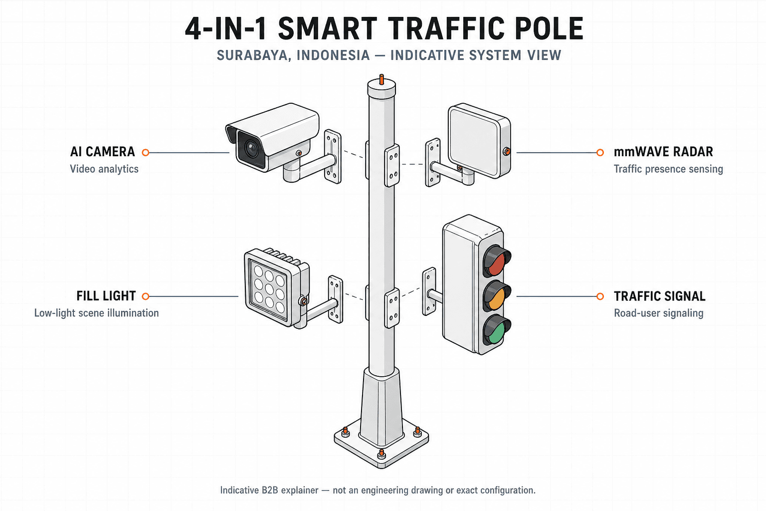
A recommended Surabaya architecture uses the SOLARTODO 5-layer stack: Perception, Edge AI, Communications, City Brain, and Applications. At the perception layer, the 4K AI camera and 77 GHz radar detect vehicles, pedestrians, incidents, queues, and movement classes. At the edge layer, NVIDIA Jetson filters events locally so bandwidth is reserved for actionable metadata and selected video evidence. At the city layer, TrafficGPT enables natural-language queries such as “show intersections with abnormal pedestrian waits in the last 30 minutes” or “compare Ahmad Yani inbound delay before and after rain.”
The cooperation model should be BOT with zero upfront municipal CAPEX where procurement objectives prioritize speed, measurable availability, and lifecycle maintenance. BOT is especially relevant where a city wants AI traffic capabilities but prefers performance-linked service payments over full equipment purchase. EPC turnkey remains suitable when a government budget line already covers civil works and acceptance testing, while joint venture is better for wider smart-city monetization such as telecom leasing or regional data services. For this Surabaya guide, the required model is BOT.
Technical Specifications
The specified Surabaya system uses 8 m L-arm galvanized steel poles with 4K AI, 77 GHz radar, LED signaling, and under-50 ms edge response.
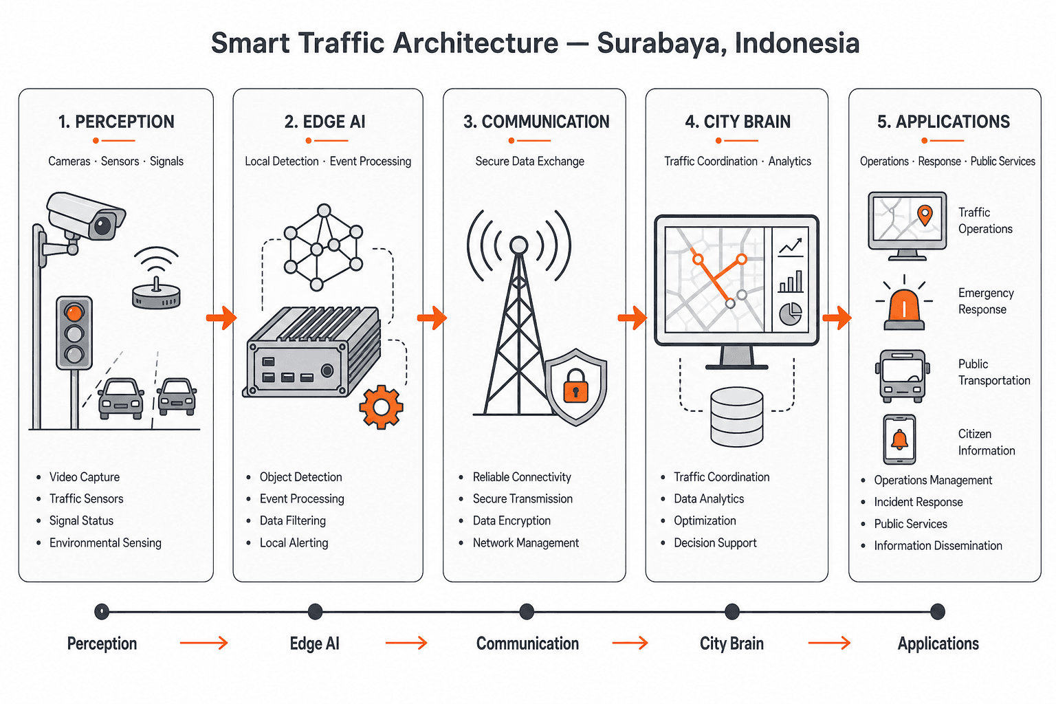
Core configuration for SOLARTODO Smart Traffic System:
- Product form: 4-in-1 Smart Traffic Pole, one base form, L-arm hot-dip galvanized steel pole, dark grey finish.
- Quantity profile: 14 intersections, with approximately 4-12 poles per intersection depending on approach count and auxiliary detection points.
- Height class: 8 m for the specified Surabaya urban-intersection configuration; 6 m and 10 m variants are reserved for smaller streets or highway/gantry-like requirements.
- Perception modules: 4K AI camera with 98% stated accuracy, 45+ detection types, and less than 50 ms response.
- Radar module: 77 GHz mmWave radar for vehicle presence, speed, distance, lane movement, and low-visibility support.
- Lighting and signal modules: LED fill light plus LED signal head integrated as always-on modules.
- Edge AI: NVIDIA Jetson processor at each smart pole or intersection node for local inference and event filtering.
- Application features: pedestrian detection, adaptive signal optimization, and incident auto-alert.
- Communications: 5G/fiber backhaul to the TrafficGPT central platform for dashboards and natural-language queries.
- Standards alignment: NTCIP for traffic-device interoperability and GB 25280 for traffic signal equipment reference.
- Local supply interface: 230 V, 50 Hz AC service with grounding, surge protection, waterproof cabinet design, and utility coordination.
The engineering reason for combining camera and radar is resilience. Cameras provide classification, lane behavior, pedestrian intent, and incident evidence; radar provides speed and object presence under rain glare, night reflections, and dirty-lens conditions. FHWA states, “All adaptive systems are critically linked to good detection systems,” which supports dual-sensor design rather than camera-only traffic control. In Surabaya’s rain and coastal humidity, this redundancy is a maintenance and performance requirement, not an optional premium.
The control system should be integrated with existing city workflows rather than treated as a standalone pole sale. PM 76/2021 provides the national policy frame for intelligent traffic management in Indonesia, while Dishub Surabaya’s existing SITS/ATCS history creates a practical migration path. SOLARTODO should therefore supply NTCIP-compatible interfaces, API documentation, event logs, and acceptance dashboards that allow municipal traffic engineers to verify detection accuracy, queue estimates, and signal phase changes.
Implementation Approach
A 14-intersection Surabaya BOT rollout should be phased across 4 steps: survey, civil works, integration, and 30-60 day optimization.
Implementation should start with intersection classification rather than immediate equipment shipment. The survey phase should record approach geometry, existing signal heads, drainage levels, cabinet locations, 230 V service points, fiber or 5G signal quality, pedestrian crossings, freight-turning paths, and installation access. In old-town or port-influenced corridors, narrow sidewalks and legacy underground utilities can limit foundation size, boom-swing radius, and night-work windows. These constraints should be mapped before confirming the exact 4-12 pole count per intersection.
The procurement and logistics phase should use CKD or modular shipment planning to reduce container volume and simplify inland delivery from port to staging yard. Surabaya’s port-city logistics are an advantage for import handling, but the final kilometer can still be constrained by dense streets, overhead cables, shopfront setbacks, and drainage works. Pole sections, L-arms, LED signal heads, radar modules, cameras, Jetson edge units, cabinets, and fasteners should be packed by intersection package. Each package should include waterproof labeling and corrosion-protected hardware suitable for humid coastal storage.
Civil works should prioritize foundations, cable ducts, grounding, cabinet plinth elevation, and safe traffic management during installation. In flood-prone corridors, cabinet base elevation and conduit sealing are as important as pole strength. The installation sequence would typically be foundation curing, pole erection, L-arm alignment, sensor mounting, power connection, network testing, then signal and AI commissioning. A practical 14-intersection program can be staged by corridor so city engineers can validate one operating cluster before scaling to the next.
Commissioning should use both technical and traffic acceptance criteria. Technical acceptance includes voltage stability, grounding resistance, camera calibration, radar alignment, 5G/fiber uptime, NTCIP message exchange, and TrafficGPT event ingestion. Traffic acceptance should measure queue length, pedestrian detection reliability, incident alert latency, and signal-plan adjustments during morning peak, evening peak, rain events, and school or market surges. SOLARTODO should provide training for field technicians, control-room operators, and traffic engineers so the BOT model does not create vendor lock-in.
Expected Performance & ROI
Surabaya should evaluate ROI using 10%+ adaptive-signal travel-time improvement benchmarks, BOT cash-flow relief, and reduced manual incident monitoring burden.
According to FHWA (2016), many adaptive signal control studies improve average metrics such as travel time, delay, fuel consumption, and emissions by 10% or more, with 50% or more possible in poor baseline conditions. For Surabaya, conservative planning should use the 10% benchmark until local before-and-after data are collected. The ROI case is not only fuel or time savings; it also includes fewer manual CCTV-only reviews, faster incident detection, and better pedestrian priority during peak crossing windows.
A BOT model changes the payback conversation because the municipality can avoid full upfront equipment purchase. Instead of treating approximately 56-168 poles as a one-time CAPEX burden, the city can structure availability payments or service fees tied to uptime, detection accuracy, response time, and monthly reporting. This is useful where municipal agencies need proof of operational value before wider procurement. EPC turnkey may still be cheaper over a long life if the city has capital budget, but BOT reduces adoption friction for a first corridor-scale modernization.
For lifecycle planning, the primary maintenance drivers are coastal corrosion, dirty camera covers, cabinet water ingress, power-quality events, and sensor misalignment after storms or road works. A realistic Surabaya maintenance plan should include quarterly optical cleaning, annual radar/camera recalibration, surge-protection inspection after severe storms, and hot-dip galvanizing checks near coastal corridors. Because the smart pole combines four modules, field visits can service camera, radar, LED fill, and signal hardware in one traffic-control operation.
Comparison Table
An 8 m Smart Traffic System pole is the best Surabaya fit against 6 m local-street poles and 10-12 m highway variants.
| Option | Best Surabaya Use | Height | Sensors | Backhaul | Procurement Fit | Main Tradeoff |
|---|---|---|---|---|---|---|
| 6 m smart pole | Minor streets, compact pedestrian crossings | 6 m | 4K AI + 77 GHz radar | 5G/fiber | EPC or BOT | Lower camera perspective on wide roads |
| Recommended SOLARTODO system | 14 urban arterial intersections | 8 m | 4K AI + 77 GHz radar + LED fill + LED signal | 5G/fiber to TrafficGPT | BOT zero upfront | Requires coordinated foundation and cabinet works |
| Highway/port access variant | Freight corridors and gantry-like views | 10-12 m | 4K AI + radar, extended mounting | Fiber preferred | EPC turnkey | Higher civil cost and heavier lifting plan |
| CCTV-only retrofit | Visual monitoring without adaptive control | Existing poles | Camera only | Existing network | Low CAPEX | Weak automation and poorer rain/night redundancy |
| Loop-detector upgrade | Legacy actuated signal support | Existing signal poles | Pavement loops | Wired controller | Narrow retrofit | Road cutting and flood-related pavement maintenance |
The comparison favors the 8 m SOLARTODO pole because it matches the provided 14-intersection configuration while avoiding the cost and permitting burden of highway-class structures. It also directly addresses Surabaya’s local risk mix: wet-season ponding, dense urban crossings, port-related traffic, and existing ITS expectations. A camera-only retrofit is cheaper, but it does not provide the radar redundancy and edge AI needed for automated incident alerts and adaptive optimization.
Pricing & Quotation
SOLARTODO’s 14-intersection Surabaya pricing should be quoted by FOB, CIF, or EPC scope, with BOT available for zero-upfront procurement.
SOLARTODO offers three pricing tiers for this product line: FOB Supply (equipment ex-works China), CIF Delivered (including ocean freight and insurance), and EPC Turnkey (fully installed, commissioned, with 1-year warranty). Volume discounts are available for large-scale deployments. Configure your system online for an instant estimate, or request a custom quotation from our engineering team at [email protected].
For Surabaya, quotation inputs should include the final pole count, foundation drawings, cabinet elevation requirements, 5G versus fiber availability, traffic-management work windows, and integration scope with existing SITS or ATCS platforms. BOT proposals should also define service duration, uptime service-level targets, data ownership, replacement stock, warranty handling, and acceptance metrics. A technical buyer should request separate line items for pole hardware, AI modules, civil works, communications, platform licensing, commissioning, and maintenance.
Frequently Asked Questions
These 10 answers cover Surabaya-specific specifications, timeline, ROI, maintenance, pricing, warranty, installation, and comparison for a 14-intersection Smart Traffic System.
Q1: What Smart Traffic System configuration is recommended for Surabaya? The recommended configuration is 14 intersections using 8 m dark grey hot-dip galvanized L-arm steel poles. Each pole integrates a 4K AI camera, 77 GHz mmWave radar, LED fill light, and LED signal head. Depending on intersection geometry, approximately 56-168 poles would be required, using 4-12 poles per intersection.
Q2: Why is the 8 m pole class preferred instead of 6 m or 10 m? The 8 m pole gives better camera and radar sightlines for Surabaya’s wide arterial intersections while avoiding the civil cost of 10-12 m highway variants. A 6 m pole can fit narrow neighborhood crossings, but the specified 14-intersection program targets larger signalized roads with pedestrian and vehicle detection needs.
Q3: How long would a 14-intersection rollout typically take? A practical schedule is usually 8-16 weeks after final survey and permitting, depending on civil works, power access, fiber readiness, and traffic-control work windows. The fastest sequence is corridor-based: survey all sites, prepare foundations, install poles by cluster, then commission TrafficGPT analytics and adaptive signal functions.
Q4: What ROI should Surabaya use for planning? Surabaya should model ROI conservatively using FHWA’s 10% or higher adaptive-signal improvement benchmark for travel time, delay, fuel use, and emissions. BOT financing changes payback because upfront municipal CAPEX can be 0. Final ROI should be validated using local before-and-after queue, travel-time, and incident-response data.
Q5: How does the system handle rain, humidity, and coastal salt air? The recommended hardware uses hot-dip galvanized steel poles and sealed sensor housings, with radar added to support detection when camera visibility is degraded by rain glare or dirty lenses. Surabaya’s wet season and coastal humidity require elevated cabinets, sealed conduits, surge protection, quarterly cleaning, and annual sensor recalibration.
Q6: Can the system integrate with existing Surabaya SITS or ATCS workflows? Yes, integration should be planned through NTCIP-compatible interfaces, API event feeds, and control-room dashboards. Surabaya already has SITS and ATCS operating history, so the recommended approach is phased migration rather than replacement shock. TrafficGPT can add natural-language queries while existing operators continue using familiar congestion and incident workflows.
Q7: What is included in EPC turnkey pricing? EPC turnkey typically includes site survey, foundation design, pole supply, camera and radar installation, LED signal integration, cabinet works, power connection, communications setup, TrafficGPT commissioning, operator training, and 1-year warranty. Civil-work complexity, night-work permits, fiber trenching, and drainage elevation requirements can materially change the final price.
Q8: What warranty and maintenance model is recommended? A 1-year warranty should cover equipment defects, commissioning defects, and platform acceptance support. For Surabaya, maintenance should include quarterly optical cleaning, annual AI/radar calibration, corrosion inspection, cabinet waterproofing checks, and surge-protection inspection after severe storms. BOT contracts should tie payments to uptime, alert latency, and detection performance.
Q9: How is installation managed without disrupting traffic? Installation should be phased by corridor and scheduled during low-traffic or night windows where permitted. The usual sequence is foundation preparation, curing, pole erection, L-arm alignment, module mounting, cabinet connection, and signal commissioning. Temporary traffic management is essential near old-town streets, port routes, and dense retail corridors.
Q10: How does this compare with CCTV-only monitoring? CCTV-only systems help operators see congestion but do not provide the same automated detection, radar redundancy, or adaptive signal optimization. The SOLARTODO Smart Traffic System combines 4K AI, 77 GHz radar, LED signal control, edge NVIDIA Jetson processing, and TrafficGPT analytics, making it better suited to real-time incident alerts and pedestrian detection.
References
These 7 references support Surabaya demographics, rainfall, drainage risk, Indonesian ITS regulation, adaptive-signal ROI, and international ITS standards.
- Pemerintah Kota Surabaya (2026): City profile reports approximately 2.87 million residents, 333 km² area, 31 districts, and 153 urban villages.
- BPS Kota Surabaya (2024): “Kota Surabaya Dalam Angka 2024” provides official city statistical context for demographic and infrastructure planning.
- WMO/BMKG (2026): Surabaya climatology lists monthly maximum temperatures around 30.1-33.4°C and January mean rainfall of 327 mm.
- Pemerintah Kota Surabaya / DSDABM (2026): Drainage and flood-control updates identify pump houses, channel integration, road ponding, and storm-response constraints.
- Government of Indonesia, Ministry of Transport (2021): PM 76/2021 regulates intelligent transport management systems for road traffic and transport.
- FHWA (2016): Adaptive Signal Control guidance reports average performance improvements of 10% or more, with 50% or more in poor baseline conditions.
- ITU (2026): Intelligent Transport Systems and Smart Mobility guidance links AI, IoT, and connectivity to safer, efficient, sustainable transportation channels.
Equipment Deployed
- 14 intersections × 8 m dark grey hot-dip galvanized L-arm steel pole configuration
- 4-in-1 Smart Traffic Pole with 4K AI camera, 77 GHz mmWave radar, LED fill light, and LED signal head
- 4K AI camera with 98% accuracy, 45+ detection types, and under 50 ms response
- NVIDIA Jetson edge AI processor for local inference and event filtering
- 5G/fiber backhaul to TrafficGPT central platform with natural-language query support
- Pedestrian detection, adaptive signal optimization, and incident auto-alert features
- NTCIP and GB 25280 standards alignment
- BOT cooperation model with zero upfront municipal CAPEX